The Dutch did an outstanding job on this accident investigation. The report is thorough, very well written, and conveys accurately what happened to bring this airplane down. But it didn't go far enough.
— James Albright

Updated:
2017-05-10
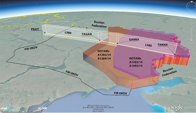
Ukrainian NOTAMS, from
Dutch Safety Board Report, Appendix D.
I normally present these case studies with an emphasis on what the pilot could have done to prevent it, so as to help the rest of us to avoid recurrence. I doubt these pilots ever saw the missile and probably died very quickly as the missile exploded right on top of them. Death for everyone seated behind them was not so quick. So what was the problem with this report?
In my view, the aircraft was brought down by a 9M38M1 surface-to-air missile shot from a Soviet-made Buk missile system, just as the report proves. But that wasn't the cause. The cause is an anemic international NOTAM system that failed to convey a known danger to an unsuspecting aviation community. Is there a solution? Yes, see: The Notice to Airmen (NOTAM) System is Messed Up.
The 279 pages of the accident report are a fascinating read. The 176 pages of appendices are also useful, especially the several pages of NOTAMs that were in effect the day of the shoot down as well as those presented the day after. I briefly cover the aspects of the missile just to relate how an investigation must necessarily identify the mechanical cause of the accident as a first step. The report then covers the NOTAMS rather clinically and seems to say "everyone else missed this too, oh well." Well that isn't exactly true. Eight operators knew enough to avoid this airspace while 160 other flights flew right over it. There has to be a better way.
Everything here is from the references shown below, with a few of my comments. Mark Zee from the Flight Service Bureau has an excellent insight on all this: https://medium.com/@markzee/mh17-a-darker-truth-21dc21879fa7.

1
Accident report
- Date: 17 July 2014
- Time: 16:20
- Type: Boeing 777-2H6ER
- Operator: Malaysia Airlines
- Registration: 9M-MRD
- Fatalities: 15 of 15 crew, 283 of 283 passengers
- Aircraft fate: Destroyed
- Phase: En route
- Airport (departure): Amsterdam-Schiphol International Airport (AMS/EHAM), Netherlands
- Airport (arrival): Kuala Lumpur Subang International Airport (KUL/WMKK), Malaysia
2
Narrative
- On 17 July 2014, at 13.20 (15.20 CET) a Boeing 777-200 with the Malaysia Airlines nationality and registration mark 9M-MRD disappeared to the west of the TAMAK air navigation waypoint in Ukraine. A notification containing this information was sent by the Ukrainian National Bureau of Air Accident Investigation (NBAAI) on 18 July 2014, at approximately 06.00 (08.00 CET). The NBAAI was notified by the Ukrainian State Air Traffic Service Enterprise (UkSATSE) that communication with flight MH17 had been lost. A signal from the aeroplane´s Emergency Locator Transmitter had been received and its approximate position had been determined.
- The aeroplane impacted the ground in the eastern part of Ukraine. The wreckage was spread over several sites near the villages of Hrabove, Rozsypne and Petropavlivka. Six wreckage sites were identified, spread over about 50 km. Most of the wreckage was located in three of these sites to the south-west of the village of Hrabove. This is about 8.5 km east of the last known position of the aeroplane in flight. At two sites, post-impact fires had occurred.
- All 298 persons on board lost their lives.
- The in-flight disintegration of the aeroplane near the Ukrainian/Russian border was the result of the detonation of a warhead. The detonation occurred above the left hand side of the cockpit. The weapon used was a 9N314M-model warhead carried on the 9M38-series of missiles, as installed on the Buk surface-to-air missile system.
- Other scenarios that could have led to the disintegration of the aeroplane were considered, analysed and excluded based on the evidence available.
- The airworthy aeroplane was under control of Ukrainian air traffic control and was operated by a licensed and qualified flight crew.
- Flight MH17 was shot down over the eastern part of Ukraine, where an armed conflict broke out in April 2014. At first this conflict took place mainly on the ground, but as from the end of April 2014 it expanded into the airspace over the conflict zone: Ukrainian armed forces’ helicopters, transport aeroplanes and fighters were downed.
- On 14 July, the Ukrainian authorities reported that a military aeroplane, an Antonov An-26, had been shot down above the eastern part of Ukraine. On 17 July, the authorities announced that a Sukhoi Su-25 had been shot down over the area on 16 July. According to the authorities, both aircraft were shot down at an altitude that could only have been reached by powerful weapon systems. The weapon systems cited by the authorities, a medium-range surface-to-air missile or an air-to-air missile, could reach the cruising altitude of civil aeroplanes. Consequently they pose a threat to civil aviation.
Source: Dutch Safety Board Report, pp. 9 - 10
Three days prior to this incident, a large airplane was shot down at high altitude. A day prior, a second aircraft was shot down. Both appeared to have been downed by surface to air missiles.
- Although (Western) intelligence services, politicians and diplomats established the intensification of fighting in the eastern part of Ukraine, on the ground as well as in the air, it was not recognised that as a result there was an increased risk to civil aeroplanes flying over the conflict zone at cruising altitude. The focus was mainly on military activities, and the geopolitical consequences of the conflict.
- On 6 June 2014, the airspace above the eastern part of Ukraine was restricted to civil aviation from the ground up to an altitude of 26,000 feet (FL 260). This enabled military aeroplanes to fly at an altitude that was considered safe from attacks from the ground and eliminated the risk that they would encounter civil aeroplanes, which flew above FL 260. The authorities automatically assumed that aeroplanes flying at a higher altitude than that considered safe for military aeroplanes, were also safe.
Source: Dutch Safety Board Report, pp. 9 - 10
They appeared to have assumed the only threat was from MANPADS ("Man-portable air-defense systems") which are typically low altitude weapons. This ignores the fact that much higher altitude capable systems were available from former Soviet Union sources.
- On 14 July 2014, the Ukrainian authorities increased the upper limit of the restricted airspace imposed on civil aviation to an altitude of 32,000 feet (FL 320). The exact underlying reason for this decision remains unclear.
Source: Dutch Safety Board Report, pp. 9 - 10
If you accept the conclusion that the threat is more than just the lower altitude MANPADS, then you need to include the full capability of the higher altitude threats. Many of these had altitude limits near 80,000 feet. As far as I can tell, the 32,000 feet limit doesn't really apply to any of the available weapons. Of the SAMs available in the area the SA-11/SA-17 could reach 72,000 feet, the S-400 could reach 98,000 feet, the SA-6 could reach 36,000 feet, and the S-75A could reach 114,000 feet. MH17 was downed by an SA-11.
- The Ukrainian authorities did not consider closing the airspace over the eastern part of Ukraine to civil aviation completely. The statements made by the Ukrainian authorities on 14 and 17 July 2014, related to the military aeroplanes being shot down, mentioned the use of weapon systems that can reach the cruising altitude of civil aeroplanes. In the judgment of the Dutch Safety Board, these statements provided sufficient reason for closing the airspace over the conflict zone as a precaution.
Source: Dutch Safety Board Report, pp. 9 - 10
This begs two questions: 1) Why not close the airspace completely? 2) If you insist on keeping it open, why set a floor of 32,000 feet? The report briefly covers the fact that Ukraine, as is common practice, was collecting revenue in exchange for the use of their airspace. This amounted to 199 million Euros in 2013, for example. But the report also states that this is only "full cost recovery," paying for the cost of operating the ATC system in Ukraine. Even if that is true, it represents jobs and can still be considered to be in the nation's best interest. The country has a vested interest in keeping the airspace open. So why 32,000 feet? It appears that was the floor for the most common users; if you raise that floor you will have fewer and fewer "customers."
- Malaysia Airlines assumed that the unrestricted airspace over Ukraine was safe. The situation in the eastern part of Ukraine did not constitute a reason for reconsidering the route. The operator stated that it did not possess any information that flight MH17, or other flights, faced any danger when flying over Ukraine.
- Not only Malaysia Airlines, but almost all airlines that used routes over the conflict zone continued to do so during the period in which the armed conflict was expanding into the airspace. On the day of the crash alone, 160 flights were conducted above the eastern part of Ukraine - until the airspace was closed.
- During the period in which the conflict in the eastern part of Ukraine expanded into the airspace over the conflict zone, from the end of April 2014 up to the crash of flight MH17, not a single state or international organisation explicitly warned of any risks to civil aviation and not a single state prohibited its airlines or airmen from using the airspace over the area or imposed other restrictions.
Source: Dutch Safety Board Report, pp. 9 - 10
I'm not sure about this. The U.S. did have a warning published but it wasn't explicit enough to prevent one U.S. operator from overflying the Ukraine on 17 July 2014. (Atlas Air). The report claims only one operator elected to avoid the airspace but there is evidence to show that five operators made that decision. What did they know and why wasn't that information common knowledge? (See: Recommendation, below, for more about this.)
- Both Ukraine and the Russian Federation had issued NOTAMs that restricted access to parts of their respective airspace up to FL 320. On 17 July parts of the airspace in both countries were restricted up to FL 320. At the time of the crash, flight MH17 was flying at FL 330 in unrestricted airspace of the Dnipropetrovsk (UKDV) FIR in the eastern part of Ukraine.
Source: Dutch Safety Board Report, ¶2.9.4
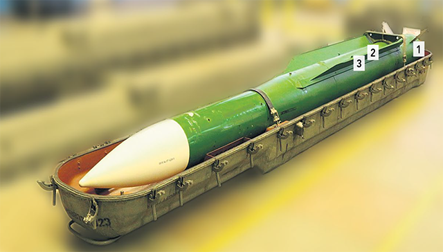
Image of 9M38M1 surface-to-air missile, from Dutch Safety Board Report, figure 35.
- During the recovery of the wreckage, a number of parts that did not originate from the aeroplane and its content were found in the wreckage area. The parts found appeared to be connected with a surface-to-air missile.
- The shape and form of the parts recovered is consistent with a 9M38 series surface-to-air missile.
Source: Dutch Safety Board Report, ¶2.12.2.8
3
Analysis
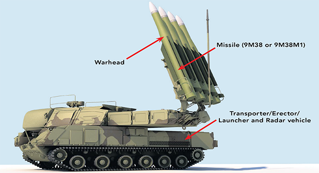
A typical Buk surface-to-air missile system, from Dutch Safety Board Report, figure 57
- It is noted that the shapes of the pre-formed fragments found in the wreckage and the bodies of crew members in the cockpit; bow-tie and cubes, are only found in the 9N314M warhead. The 9N314M warhead can be fitted to the 9M38M1 missile. These missiles are launched from a Buk surface-to-air missile system.
- The Buk surface-to-air missile system is present in this region and is the only weapon system whose missiles have warheads containing, among other fragments, pre-formed fragments in the shape of a bow-tie in its warhead.
- The Buk is a medium range, mobile weapon system equipped with semi-active radar guided missiles. Its generic designation in the Russian Federation is 9K37 and its NATO designation is SA-11. The Buk became operational in 1979 and has since then gone through several upgrades. The system was designed in the former Soviet Union as a further development of its predecessor, the 2K12 Kub missile system (NATO designation, SA-6).
- According to the manufacturer of the Buk surface-to-air missile system, JSC Concern Almaz-Antey, the oldest version of the missile system (Kub) and the latest version (Buk-M2 series) could not have been used because they are not equipped with a 9N314M warhead. According to the Kyiv Research Institute for Forensic Expertise of the Ministry of Justice, both the 9M38 and 9M38M1 missiles can carry the 9N314M warhead.
- The Buk surface-to-air missile system is able to engage targets at altitudes up to 70,000 or 80,000 feet.
- The Buk system’s missiles (the 9M38 and 9M38M1 missiles) are equipped with both an impact and a proximity fuse. The impact fuse detonates the warhead when the missile directly hits the target. However, in most cases the missile will not directly hit the target but pass closely by the target.
Source: Dutch Safety Board Report, ¶3.6.5
- The Dutch Safety Board examined the extent of the availability of aeronautical information that could have signaled increasing deterioration of the safety of the airspace above the eastern part of Ukraine.
- In March 2014, the Russian Federation issued NOTAMs for the Simferopol FIR (Crimea), in which a Russian air traffic service was introduced for the Crimea. Ukraine responded to this by issuing a NOTAM in which the message from the Russian Federation was rejected and in which was indicated that Ukraine continued to be responsible for providing air traffic services in this airspace.
- This was followed by more NOTAMs from Ukraine as well as from the Russian Federation. The situation thus created led to the possibility that civil aviation over the area would receive conflicting instructions, as the various NOTAMs made it clear that there were two air navigation service providers that both claimed responsibility for air traffic management. This could present a risk to the safety of air traffic due to possible conflicting instructions. On 2 April 2014, ICAO published a State Letter in which Member States were informed of the potential risks to the safety of civil flights in the Simferopol FIR, as a result of the conflicting instructions: ‘Due to the unsafe situation where more than one ATS provider may be controlling flights within the same airspace from 3 April 2014, 0600 UTC onwards, consideration should be given to measures to avoid the airspace and circumnavigate the Simferopol FIR with alternative routings.'
Source: Dutch Safety Board Report, ¶5.2
The phrase "avoid the airspace" is about as clear as it gets from the normally bureaucratic and overly restrained ICAO. But their recommendation had to do with the bureaucratic infighting over airspace control, not the military threat.
- Also on 2 April, and in response to the ICAO State Letter, the Network Manager at EUROCONTROL urgently recommended that operators avoid Crimean airspace (the Simferopol FIR) and select alternative routes. On 3 April 2014, EASA issued a Safety Information Bulletin (SIB), in which EASA highlighted ICAO’s warning. In the State Letter of 2 April 2014 regarding Simferopol FIR, ICAO also announced that it would continue to remain active in coordinating all parties regarding any dangers for civil aviation: ‘ICAO continues to actively coordinate with all involved authorities, international organisations, airspace users and other states in the region regarding developments as they unfold, specifically those which could impact flight safety.’ However, during the period of 2 April through 17 July 2014, the period during which the armed conflict in the eastern part of Ukraine broke out and intensified, ICAO did not mention the situation in Ukraine again.
Source: Dutch Safety Board Report, ¶5.2
The ICAO was deeply interested in the dispute over which nation owned the rights to administer that airspace, but not interested at all in the threat posed by ground forces against civil air traffic.
- The U.S. Federal Aviation Administration (FAA) published FDC NOTAM 4/3635 on 4 March 2014. In this NOTAM, the FAA warned U.S. operators and airmen that were flying to, from or over Ukraine to be careful in connection with potential instability. From this information it appeared that there were increasing military activities in Ukraine airspace and in the area of military aerodromes. Civil aviation could encounter military activities, particularly in the Crimea region: ‘Potentially hazardous situation - Flight operations into, out of, within, or over the Ukraine U.S. Operators and airmen should exercise caution when operating in the Lvov (UKLV), Kyiv (UKBV), Dnepropetrovsk (UKDV), Odessa (UKOV) and Simferopol (UKFV) flight information regions (FIRs) due to the potential for instability. Information from the European Emergency Coordination Crisis Cell and open source media reports indicates there is an increased military presence in the airspace over Ukraine and in the vicinity of military aerodromes. Civil flight operations in the Ukraine, particularly in the Crimean region, may be exposed to military activity. U.S. operators and airmen flying into, out of, within or over the Ukraine must review current information and NOTAMs, comply with all applicable FAA Regulations and directives and exercise extreme caution.’ This NOTAM was valid up until 31 March 2014.
- The U.S. FAA subsequently issued FDC NOTAM 4/2816 on 3 April 2014. This contained a flight prohibition imposed on U.S. operators and airmen pertaining to the use of the airspace above Crimea, the Black Sea and the Sea of Azov. This NOTAM also contained a warning related to all other Ukrainian FIRs: ‘U.S. operators and airmen flying into, out of, or within Lvov (UKLV), Kyiv (UKBV), Dneptropetrovsk (UKDV), and Odessa (UKOV) FIRs, as well as airspace in the Simferopol (UKFV) FIR that is outside the lateral limits of the airspace over the Crimea, the Black Sea, and the Sea of Azov […] must review current security/threat information and NOTAMs; comply with all applicable FAA regulations, operations specifications, management specifications, and letters of authorisation, including updating B450; and exercise extreme caution due to the continuing potential for instability.’ (Emphasis added by the Dutch Safety Board.)
- On 23 April, this was followed by FDC NOTAM 4/7667 (A0012/14), which contained FAA SFAR 113 and repeated previous prohibitions and warnings, enacting them. The warning pertaining to the remainder of Ukraine was formulated in general terms and did not contain any specific information about the armed conflict and the potential risks it could present to civil aviation. Therefore, prior to the crash of MH17, no state or international organisation other than Ukraine issued a specific safety warning about the eastern part of Ukraine.
Source: Dutch Safety Board Report, ¶5.2
"Exercise extreme caution" seems to rise to the level of a "safety warning" but could have been made more explicit.
- On 17 July 2014, the day of the crash of flight MH17, 28 NOTAMs were in force pertaining to the airspace in the eastern part of Ukraine. Eight of those NOTAMs referred to airspace restrictions. A number of NOTAMs that specified a restriction pertained to the airspace at low altitudes, below 5,000 feet. On 5 June 2014, the Ukrainian authorities published NOTAM A1255/14 (for the airways) and A1256/14 (for the area) with which they temporarily restricted the airspace above the eastern part of Ukraine below FL 260 70 for civil aviation. These NOTAMs were valid from 6 June until 30 June 2014. On 26 June, the Ukrainian authorities published NOTAM A1383/14 (for the area) and A1384/14 (for the airways) with which they prolonged the temporary restrictions. These NOTAMs were valid from 1 until 28 July 2014. On 14 July 2014, the Ukrainian authorities increased the airspace restriction to FL 320. The relevant NOTAMs 71 were valid from 14 July until 14 August 2014. The reason for the airspace restrictions was not specified in the NOTAMs.
Source: Dutch Safety Board Report, ¶5.2
The most pertinent of these NOTAMs are presented below.
- Since flight MH17 also flew over the Rostov FIR, the Russian NOTAMs concerned were also part of the briefing package for flight MH17. Despite the internal contradictions they were accepted by the automated flight plan system. The cited information in the NOTAM on the conflict is not automatically obvious from the selection, but it becomes apparent if someone studies the NOTAMs package in detail.
Source: Dutch Safety Board Report, ¶5.2
- In the months prior to 17 July, reports also circulated in the media (including social media) on the presence of weapons, including surface-to-air missiles, in the hands of the armed groups that were fighting the Ukrainian government in the eastern part of Ukraine. For example armed groups seized the Ukrainian military air defence base A-1402 on 29 June 2014. Reports in the media indicated that, as a result, the armed groups had also been able to acquire a Buk system. The Ukrainian authorities, however, declared in the media that this system was not operational.
- Western media reported that politicians, diplomats and military leaders expressed their concerns about weapons possibly being supplied by the Russian Federation to the armed groups and the build-up of Russian troops and equipment on the border with Ukraine. The involvement of the Russian Federation was denied in Russian media.
- The precise nature, scope and operational level of the military capacities of the various parties involved in the conflict around 17 July 2014 are not easy to establish by the Dutch Safety Board, even in retrospect. Although various media reported on the possible weapons capability in the area in the months prior to the crash, they do not constitute validated and verified information. In addition, based on open sources it is not possible to establish with certainty what equipment was involved and to what extent this equipment was operational.
Source: Dutch Safety Board Report, ¶5.5
Since it is apparent those who are responsible for reporting on the safety of the airspace are more interested in keeping the airspace open and adhering to political and bureaucratic protocol than keeping that airspace safe, it is up to us to keep up with this kind of news.
- On 14 July 2014, the Ukrainian authorities announced in a press statement that an Antonov An-26 had been shot down while flying at an altitude of 6,500 metres. Later, altitudes of 6,200 147 and 6,300 metres were also cited. All these altitudes are out of the range of MANPADS. According to the authorities, the aircraft was shot down with a weapon that could reach the cruising altitude of civil aircraft.
Source: Dutch Safety Board Report, ¶6.6.2
6,500 meters comes to 21,325 feet.
- On 14 July, the Ukrainian authorities closed the airspace below FL 320 to civil aviation. The Dutch Safety Board was not able to establish whether this was a direct result of the shooting of the Antonov An-26. According to the Ukrainian authorities there was no connection and they stated the measure had been planned prior to, but was accelerated as a result of the incident. They stated that the aircraft had been shot down below FL 230-240, which the military authorities had considered to be safe for military aeroplanes. As a result, the authorities believed that there was no threat to civil aircraft above FL 320.
Source: Dutch Safety Board Report, ¶6.6.2
We don't know what kind of missile was used to down the An-26.
- On 17 July 2014, the day of the crash of flight MH17, the use of the airspace above the eastern part of Ukraine was restricted below FL 320. The airspace above FL 320 was open to civil aviation. After an emergency beacon was activated at around 13.20, indicating that flight MH17 had crashed, UkSATSE made the decision at 15.00, at the tactical level, to also restrict the airspace above FL 320. From that moment, only military aircraft were permitted to fly in that area (NOTAM A1507/14). This meant that the entire airspace above the eastern part of Ukraine was closed to civil aviation.
Source: Dutch Safety Board Report, ¶6.3
- Risks to civil aviation may arise in conflict areas if military air activities are being carried out and if medium or long-range surface-to-air missiles or air-to-air missiles are being used in the armed conflict. The study of a number of conflict areas shows that sovereign states, which are responsible for managing the airspace, rarely close the airspace; they may, on occasion, and possibly temporarily, restrict the altitude at which civil aircraft are allowed to fly and they do not share any or virtually any information about the armed conflict with airspace users. The airspace management by the State of Ukraine above the conflict area in the eastern part of Ukraine fits this pattern.
- Ukraine’s NOTAMs related to the eastern part of Ukraine do not state the reason for the airspace restrictions, as recommended in ICAO Doc 9554-AN/932. As a result, airspace users were not informed to the greatest possible extent. States involved in other conflict areas also barely inform airspace users, which is inconsistent with ICAO recommendations.
- In the (non-binding) document Doc 9554-AN/932, ICAO recommends that, in the case of conflicts, information should be provided in NOTAMs about the nature of a threat that forms the rationale for the NOTAM.
Source: Dutch Safety Board Report, ¶6.6.4
After the shoot down the Ukrainians simply removed the 32,000 foot altitude limit. The Russians, on the other hand, also added the phrase "DUE TO COMBAT ACTIONS."
- In July 2014, four relevant NOTAMs were in force in the airspace in the Dnipropetrovsk FIR (UKDV). The airspace in the eastern part of Ukraine was open above FL 260 and later above FL 320. Malaysia Airlines automatically processed these NOTAMs via the flight plan system used for this purpose. All the cited NOTAMs were included in the briefing package for flight MH17. For Malaysia Airlines, these NOTAMs did not constitute any basis for not operating the flight through Ukraine’s airspace.
- Malaysia Airlines was aware of the ICAO State Letter published on 2 April 2014 about the Simferopol FIR, which informed Member States about the potential risks to the safety of civil flights in the Simferopol FIR (Crimea) due to two air traffic control centres claiming the same region. The same applies to EASA’s subsequent Safety Information Bulletin (SIB), which confirmed the warning issued by ICAO. But since Malaysia Airlines did not operate any flights over Crimea, this safety warning had no effect on Malaysia Airlines’ operations. Therefore, the decision to shift the route to the north or south of Crimea did not apply.
- Malaysia Airlines says it was not aware of SFAR 113, issued by the U.S. aviation authority (Federal Aviation Administration, FAA), dated 23 April 2014. In this safety warning, the FAA prohibited U.S. operators and airmen from flying over Crimea. Because Malaysia Airlines no longer flies over the United States, the operator has ceased monitoring the SFARs issued by the FAA. They also viewed them as a U.S. matter because, for example, U.S. operators have a risk profile that differs from that of Malaysia Airlines. The NOTAM that referred to the SFAR in question was also not included in the briefing package that Malaysia Airlines had compiled for MH17’s flight route, because this particular flight did not take-off from or land in the United States or pass through the latter’s airspace.
Source: Dutch Safety Board Report, ¶7.5.1
- The Dutch Safety Board was able to establish that just one operator decided to no longer fly over Ukraine for safety reasons. However, this decision was already made in March 2014 as a result of developments in Crimea. The armed conflict had not yet erupted in the eastern part of the country at that time. Evidently, most operators considered that there was no reason to assume that civil aviation was in any danger while flying over Ukraine at high altitude.
Source: Dutch Safety Board Report, ¶7.8.4
The "just one operator" statement is contradicted in the very next paragraph:
- The investigation highlights the fact that the developments in Crimea were the rationale behind eight of the nineteen surveyed operators altering their flight routes and no longer operate over the eastern part of Ukraine. This took place a few months before 17 July 2014, when there was no or virtually no talk of an armed conflict in the eastern part of Ukraine. Some caution has to be applied when drawing conclusions related to the extent to which operators altered their flight routes.
Source: Dutch Safety Board Report, ¶7.8.4
The report doesn't consider that the eight operators who stopped overflights earlier for one reason (political instability) continued to not overfly for the other (the armed conflict) and should not be used to buttress the decisions of others who continued to overfly the area.
According to Flight Service Bureau (now OpsGroup), at least four operators bypassed the airspace on that day:
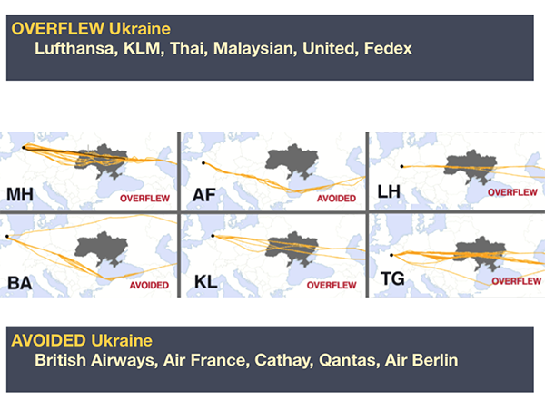
Overflew versus Avoided Ukraine from OpsGroup
4
Cause
- On 17 July 2014, Malaysia Airlines operated flight MH17, an airworthy Boeing 777-200 with the registration 9M-MRD, in cruise flight near the Ukrainian/Russian border at 33,000 feet, under the control of Ukrainian Air Traffic Control and was operated by a competent and qualified crew.
- At 13.20:03 hours (15.20:03 CET) a warhead detonated outside and above the left hand side of the cockpit of flight MH17. It was a 9N314M warhead carried on the 9M38-series of missiles as installed on the Buk surface-to-air missile system.
- Other scenarios that could have led to the disintegration of the aeroplane were considered, analysed and excluded based on the evidence available.
- The impact killed the three persons in the cockpit and caused structural damage to the forward part of the aeroplane leading to an in-flight break-up. The break-up resulted in a wreckage area of 50 square kilometres between the village of Petropavlivka and the town of Hrabove, Ukraine. All 298 occupants lost their lives.
Source: Dutch Safety Board Report, ¶10l1
5
Recommendation
(A better way)
There were 8 NOTAMs in effect at the time of the crash, each of which had an upper altitude limit of something less than MH17's cruising altitude of FL 330. When you read all 8 NOTAMS you get the idea something is very wrong with this airspace, but you have no idea what. But let's just look at the two NOTAMs that both top out at FL 320 . . .
A1492/14 NOTAM
Q) UKDV/QRTCA/IV/BO /W /260/320/4822N03807E095
A) UKDV
B) 1407141800 C) 1408142359EST
E) TEMPO RESTRICTED AREA INSTALLED WITHIN FIR DNIPROPETROVSK
BOUNDED BY COORDINATES : 495355N 0380155E 485213N 0372209E 480122N
0370253E 471352N 0365856E 465018N 0374325E 465900N 0382000E
470642N 0381324E
THEN ALONG STATE BOUNDARY UNTIL POINT 495355N 0380155E.
RESTRICTION NOT APPLIED FOR FLIGHTS OF STATE ACFT OF UKRAINE.
F) FL 260 G) FL 320)
A1493/14 NOTAM
Q) UKDV/QARLC/IV/NBO/E /260/320/4820N03716E119
A) UKDV
B) 1407141800 C) 1408142359EST
E) SEGMENTS OF ATS ROUTES CLOSED:
T242 NALEM MASOL M996 ABUGA GUKOL
G476 MASOL OLGIN W533 TOROS KUBIR
L32 NALEM KW P851 LS NESLO
A83 LS DIMAB L980 GANRA TAMAK
W538 GANRA FASAD W633 LUGAT MAKAK
L69 LAMIV GONED W644 DON GETBO
M70 BULIG TAMAK B493 PODOL FASAD
L984 BULIG FASAD W531 KOVIL PW
M136 MEBAM DON M995 OLGIN PENAK
L140 KOVIL FASAD.
FM FL 260 UP TO FL 320
Source: Dutch Safety Board Report, Appendix D
If you were planning a flight at FL 330 would either of these NOTAMS make you think your aircraft was in danger? Of course not. Even if you run that first NOTAM through a decoder, such as http://www.drorpilot.com/English/notam.htm you still don't have a clue:
Temporary RESTRICTED AREA INSTALLED WITHIN Flight information region DNIPROPETROVSK BOUNDED BY COORDINATES : 495355N 0380155E 485213N 0372209E 480122N 0370253E 471352N 0365856E 465018N 0374325E 465900N 0382000E 470642N 0381324E THEN ALONG STATE BOUNDARY UNTIL POINT 495355N 0380155E. RESTRICTION NOT APPLIED FOR FLIGHTS OF STATE Aircraft OF UKRAINE. F) FL 260 G) FL 320
So after the shoot down the Ukrainians did better, right? Afraid not:
A1517/14 NOTAM
Q) UKXX/QRTCA/IV/BO /W /000/660/4801N03731E117
A) UKDV UKFV
B) 1407180005 C) 1408172359
E) TEMPO RESTRICTED AREA BOUNDED BY COORDINATES:
495428N 0380202E 490600N 0365000E
481520N 0360510E 475542N 0355136E
460809N 0370518E 464700N 0373000E
465900N 0382000E 470642N 0381324E
THEN ALONG STATE BOUNDARY UNTIL POINT 495428N 0380202E CLOSED.
F) SFC G) UNL
If you are paying attention, you will see the affected altitudes are from SFC to UNL. But you still don't know that this is something that can kill you if you ignore it.
On 17 July 2014, the following flights were operated in UKDV by or on behalf of these operators. In total, 160 flights were conducted on this day until the airspace was closed at 15.00 (17.00 CET) see below:
- AEROFLOT
- AEROLOGIC
- AIR ASTANA
- AIR BALTIC CORPORATION
- AIR EUROPA
- AIR INDIA
- ATLAS AIR
- AUSTRIAN AIRLINES
- AZERBAIJAN HAA YOLLARI
- BELAVIA
- CARGOLUX AIRLINES INTERNATIONAL
- DEUTSCHE LUFTHANSA
- DNIEPROAVIA
- ELITAVIA D.O.O.
- EMIRATES
- ETIHAD AIRWAYS
- EVA AIRWAYS
- HANG KHONG VIET NAM
- JET AIRWAYS
- JET EXECUTIVE INTERNATIONAL
- KLM ROYAL DUTCH AIRLINES
- LUFTHANSA CARGO AG
- MALAYSIAN AIRLINES
- ORENAIR
- PAKISTAN INTERNATIONAL AIRLINES
- QATAR AIRWAYS
- SINGAGPORE AIRLINES
- SWISS INTERNATIONAL AIRLINES
- THAI AIRWAYS
- TURKMENHOVAYOLLARY
- UKRAINE INTERNATIONAL AIRLINES
Source: Dutch Safety Board Report, Appendix R]
So 31 operators overflew the airspace and 8 avoided it. What did the 8 know that the 31 did not? Can we do better? Yes, there are two steps you need to add to your flight planning to avoid the fate of Malaysian Airlines Flight MH17:
Step One: Understand the Purpose of NOTAMS
As discussed in the article, The Notice to Airmen (NOTAM) System is Messed Up, the purpose of NOTAMS is to protect everyone except the pilot. If you have the ability to add to the NOTAM system, you will do so freely to protect yourself (not the pilot) from future blame should anything go wrong. Is there a chance an airplane can be damaged by a poorly lit sign? Write a NOTAM about it! "See! I warned you!" The result is too many insignificant NOTAMS that hide the important ones, and poorly written NOTAMS designed to protect the bureaucrat from other bureaucrats.
As pilots, we need to read each NOTAM suspiciously. What are they trying to hide?
Step Two: Improve your Situational Awareness with an Ally
As pilots we don't have the time to become political experts for every region of the world we find ourselves and we certainly don't have the expertise. But there are a lot of us out there and chances are someone knows something we need to get smart about. I recommend you arm yourself with a network of such people. I use the OpsGroup run by a friend of mine, Mark Zee. There you will find their most recent Overflight and Security Map. Here is a recent copy:
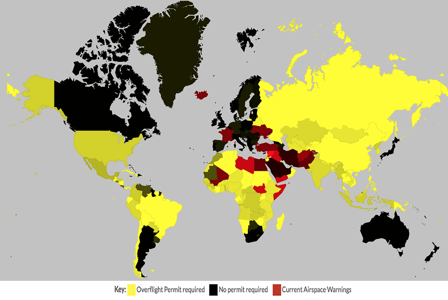
World Overflight Map, from OpsGroup, Airspace Summary
References
(Source material)
Crash of Malaysia Airlines flight MH17, Hrabove, Ukraine, 17 July 2014, Dutch Safety Board, The Hague, October 2015.