The book — AC 91-70B — no longer requires you do navigation accuracy checks, but still says you should. I think you really should.
— James Albright

Updated:
2020-12-31
I was starting to soften on my evangelical quest to get every international pilot to do nav accuracy checks but, in April of 2014, I heard of a rash of gross navigation errors after the North Atlantic adopted half-degree spacing on some of its tracks. Pilots have been blindly inputting ARINC 424 codes and ending up 30 miles off course. N4550 and 4550N, for example, are 30 nautical miles apart. They could have all been saved by, first, being more careful with the FMS inputs, and second, using navigation accuracy checks. Besides, what else you got to do when oceanic?
2 — The how: paper or PDF chart


1
The "why?"

RVSM/Nav Accuracy Log Example
The requirement to do a navigation accuracy check prior to coast-out and prior to coast-in went away with the adoption of AC 91-70B in 2016, but it remains a very good idea. We are continuing to see aircraft violated for things a good navigation accuracy check would have caught. A few reasons:
- A Navigation Accuracy Check will detect when you have made a "waypoint insertion" error, one where you simply typed in the wrong waypoint, latitude, or longitude.
- A Navigation Accuracy Check will detect when the database has an error. I've seen this twice and it happened more than a few times when half-latitude spacing was adopted a few years ago.
- Record of your Navigation Accuracy Check will impress upon an inspector that you are a careful and diligent pilot, when he or she asks for your paperwork because of a loss of separation caused by the other aircraft.
2
The how: paper or PDF chart
You can check your FMS's "claimed" position on a chart and compare that to your "reported" position off a VOR's radial / dme.
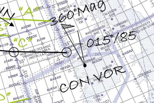
For example, the Gander VOR can be used for a coast-out NAV accuracy check.
The VOR should be drawn on the plotting chart with a magnetic north flag which would be drawn in this case 22° to the west. (This flag points to magnetic north and can be labeled “360°M / 348°T”)
The latitude and longitude from the FMS is plotted directly on the chart. A compass plotter measures the angle from the magnetic north flag to determine the aircraft is on a 270° radial and the distance is measured to be 112 nm. (We were cleared direct 51°N 050°W so didn't overfly YJT, CYMON, or DENDU.)
More about how to plot a VOR radial/DME: Plotting.
Plotting a VOR's radial / dme
3
The how: iPad application
Many iPad navigation applications can simplify the process of a navigation accuracy check. Using ForeFlight, for example:
Using two fingers (using two hands makes this easier), simultaneously press the applicable VOR and the approximate aircraft position, fine tune the VOR position so it is exact, adjust the other until the radial and DME agree with your raw data, release both fingers. The resulting point should be right on the course line. You can take a "screen grab" on most iPads by pressing the "Home" and "Power" buttons simultaneously. The resulting photo can be saved as proof you did the navigation accuracy check.
For more about how to do this with ForeFlight and a few other iPad applications, see: Plotting.

ForeFlight, nav accuracy check
4
The how: "crosspoints"
Some FMS installations include a "cross points" function that computes the position of the aircraft relative to a waypoint or VOR. The applicable VOR is inputted and compared to a raw data instrument tuned to the same VOR.
Using the G450 as an example: Select the Nav Index by pressing the NAV key.
Select CROSS PTS (LSK 5L).
Select PPOS DIR (LSK 1L)
Enter the waypoint, YQX in our example
Tuning the YQX VOR we can see the raw data on the EBDI.
In the example photo, we see that we are on the 270° radial, 113 NM from YQX.
Of course the raw data distance is greater than the actual distance because it is the slant range.

PPOS Direct, Example YQX, Page 1

VOR / DME readout
5
The how: portable GPS
Using the earlier example of plotting a radial/dme using ForeFlight, we were depending on being on our cleared course to show that we were, indeed, on course. But what if we were cleared direct the next waypoint? If we have a portable GPS connected to the iPad we can compare its displayed position against a radial / dme.
For more about how to do this with ForeFlight and a few other iPad applications, see: Plotting.

ForeFlight, nav accuracy check, with a portable GPS unit
References
(Source material)
Advisory Circular 91-70B, Oceanic and International Operations, 10/4/16, U.S. Department of Transportation