The only useful lesson from this mishap could be this: be careful what airline you allow your loved ones to fly. The Aircraft Accident Investigation Board failed to examine what exactly the pilots were using for vertical navigation and it could very well be the pilots simply started down at a given descent rate, expecting to see the runway sooner or later. Be careful who you fly with too, instrument skills are not always evident in those who possess valid licenses.
— James Albright


1
Accident report
- Date: 13 Apr 2013
- Time: 1510
- Type: Boeing 737-8GP
- Operator: Lion Air
- Registration: PK-LKS
- Fatalities: 0 of 7 crew, 0 of 101 passengers
- Aircraft Fate: Damaged beyond repair
- Phase: Approach
- Departure Airport: Bandung Airport, Indonesia (WICC)
- Destination Airport: Denpasar-Ngurah Rai Bali International Airport (WADD)
2
Narrative
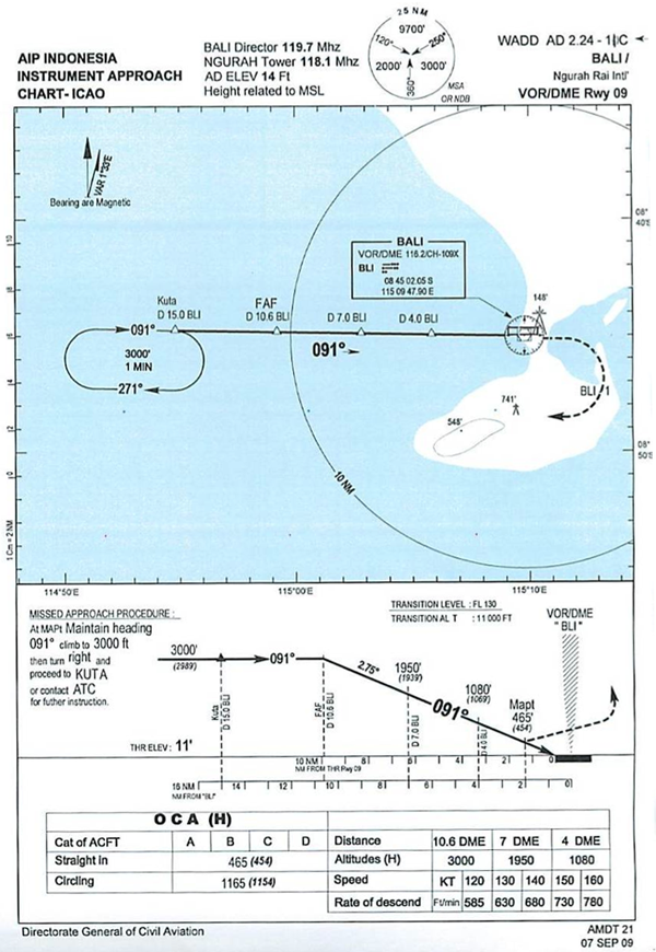
WADD VOR/DME Rwy 09 Approach, from AAIB, figure 10.
- On 13 April 2013, a Boeing 737-800 aircraft registered PK-LKS was being operated by PT. Lion Mentari Airlines (Lion Air) on a scheduled passenger flight as LNI 904. The aircraft departed from Husein Sastranegara International Airport (WICC) Bandung at 0545 UTC to Ngurah Rai International Airport (WADD), Bali, Indonesia. There were two pilots and 5 flight attendants with 101 passengers on board consisted of 95 adults, 5 children and 1 infant.
- The Second in Command (SIC) was the Pilot Flying (PF) and the Pilot in Command (PIC) was the Pilot Monitoring (PM). The flight from the departure until the start of approach was uneventful.
- The aircraft followed the VOR DME runway 09 instrument approach procedure. The weather while the aircraft was on final was raining.
- At 0708 UTC, when the aircraft was at approximately 1,300 ft, the Ngurah Tower controller saw the aircraft on final and gave a landing clearance with additional information that the wind condition was 120° / 05 knots.
- The significant information selected from the CVR, FDR and from the flight crew interview of the circumstances during final approach was as follows:
- At 0708:56 UTC, while the aircraft altitude was approximately 900 feet AGL the SIC commented that the runway was not in sight whereas the PIC commented "OK. Approach light in sight, continue". From the interview, the PIC stated that he saw flashing light at the beginning of runway 09 which was also observed by the SIC later on. Both pilots stated that the weather condition at that time was hazy and the PIC stated that he noticed that on the right side of short final area was dark.
Source: AAIB, Synopsis
According to the cockpit voice recorder, the PF/SIC stated the runway was not in sight right after the EGPWS "One Thousand" call, the PM/PIC stated "approach light in sight" and decided to continue the approach. Contrary to the text in the report, the CVR does not report the PF/SIC ever stated he had the runway in sight, and yet he continued flying the airplane with no visual references.
- At aircraft altitude approximately 550 feet AGL, the PF disengaged the autopilot and the auto throttle then continued to approach.
- At 0709:47 UTC, the CVR recorded sound similar to rain hitting the windshield. The PIC stated that the outside environment was "totally dark".
Source: AAIB, Synopsis
At this point the aircraft was well below the MDA and losing sight of the runway should have prompted an immediate go around.
- At 0709:53 UTC, while the aircraft altitude approximately 150 feet AGL the PIC took over the control. The SIC handed the control to the PIC and stated that he could not see the runway.
- At 0710:01 UTC, after the EGPWS warning "TWENTY", the PIC commanded for go around. At 0710:02 UTC, the aircraft impacted to the water.
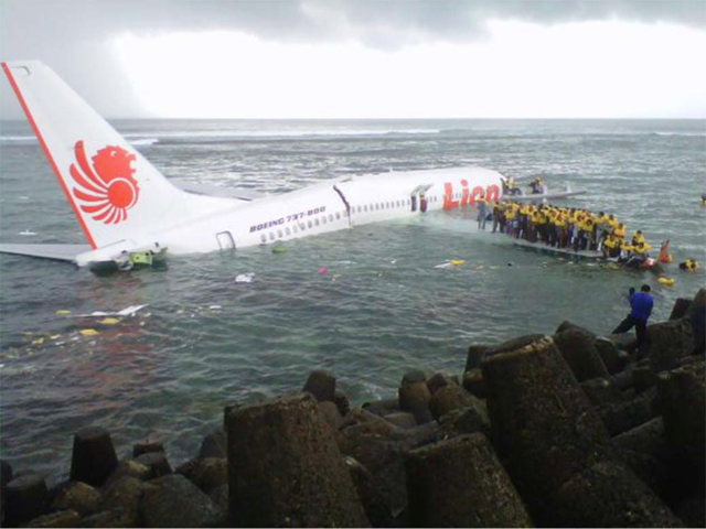
- The aircraft came to a stop facing north about 20 meters from the shore or approximately 300 meters south west of the runway 09 threshold. The Ngurah Tower controller was informed by a pilot of an aircraft was holding on short runway 09, that the aircraft that was on approach had crash into the sea near the beginning of runway 09.
Source: AAIB, Synopsis
3
Analysis
It is unclear what the pilots were using for vertical guidance during the approach. The flight data recorder shows a fairly constant descent from at least 1,500' AGL which indicates they did not level off at the MDA and attempt a "dive and drive" approach. The report does not mention a vertical navigation capability or usage in the cockpit. It is unlikely they were using the PAPI as the only external lighting reported by the pilots, erroneously as it turns out, was the approach lights. The report fails to investigate this angle to the mishap.
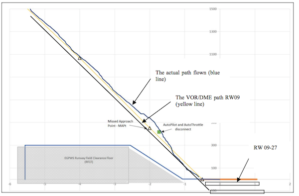
Aircraft flight path, from AAIB, figure 3.
- The CVR recorded data revealed that during the approach on short final, the SIC stated that he could not see the runway. In addition, the CVR recorded a sound, similar to rain hitting the windshield during the approach.
- A report from the pilot of an aircraft that made an approach 5 Nm behind the accident flight stated that they could not see the runway at the published minima and decided to go-around. During the second approach, the pilots could see the runway before the minima.
- Another report from a pilot of an aircraft that was holding short of runway 09 stated that while accident flight made the approach, it was raining between the final area and the runway threshold and the visibility was approximately 1 - 2 km. While PK-LKS was at 3 nm as indicated on the Traffic Collision Avoidance System (TCAS), he could not see the aircraft.
- The airport Closed Circuit Television (CCTV) camera located on the south side of the runway recorded the changing weather. The rain showed as a grey area on the left corner, and moving across the short-final area. The weather 4 minutes before the accident (Figure 5) showed the final area was clear.
Source: AAIB, ¶1.7.3
- Approach guidance facilities such as Precision Approach Path Indicator (PAPI) lights and runway lights were all serviceable. At the time of accident, only the PAPI lights were ON.
Source: AAIB, ¶1.8
- An unresolved discrepancy which occurred at 300 feet and 150 feet while the SIC had clearly said that he could not see the runway, however the PIC continued the approach.
- The PIC's expectation that he would be able to see the runway after the rain was not achieved, while the COM required that an immediate go-around should be executed after descent below MDA if the PF cannot maintain any visual reference.
- At approximately 150 feet, the SIC called that he could not see the runway but the approach was continued until after the EGPWS called "TWENTY".
Source: AAIB, ¶2.2
4
Cause
- The aircraft flight path became unstable below minimum descends altitude (MDA) with the rate of descend exceeding 1000 feet per minute and this situation was recognized by both pilots.
- The flight crew loss of situational awareness in regards of visual references once the aircraft entered a rain cloud during the final approach below minimum descends altitude (MDA).
- The PIC decision and execution to go-around was conducted at an altitude which was insufficient for the go-around to be executed successfully.
- The pilots of accident aircraft was not provided with timely and accurate weather condition despite the weather around the airport and particularly on final approach to the airport was changing rapidly.
Source: AAIB, ¶3.1
References
(Source material)
(Indonesia) Aircraft Accident Investigation Report, National Transportation Safety Committee, Republic of Indonesia, 2014, PT. Lion Mentari Airlines (Lion Air), Boeing 737-800, PK-LKS, Ngurah Rai International Airport, Bali, Republic of Indonesia, 13 April 2013.