This crew was vectored onto the approach radial 80 nm out and were cleared for the approach 44 nm out. Both pilots, apparently, did not understand the nature of this type of non-precision approach with only a final approach segment and elected to descend to their final approach altitude outside of a what the NTSB agreed was an ambiguous approach plate. Ambiguous, back then, because the pilots were trained to believe that if they were under radar control the responsibility for obstacle clearance belonged to air traffic control and that they were expected to descend to the minimum altitudes as soon as possible. Ambiguous also because air traffic control did not consider them to be under radar control and that obstacle clearance responsibility belonged to the pilot in command.
— James Albright

Updated:
2016-07-31
NTSB, AAR-74-16, page 60
Looking at the approach plate, it seems obvious to me they descended too early. But this took place four years before my first instrument flight so perhaps I am speaking with the benefit of lessons learned from their mistake. Regardless, I still think there was a lack of situational awareness: why would an instrument approach over Virginia permit an airplane to descend to 1,800' when 44 nautical miles from the airport? The final approach fix was 6 nm from the runway, they began their descent to the final approach fix altitude over 40 nm out, and they struck a mountain about 25 nm out.
The FAA and air traffic control ended up with most of the blame for this mishap, but that doesn't help the crew. A cardinal rule of avoiding a Controlled Flight Into Terrain (CFIT) is to maintain a healthy situational awareness and that begins with at least a cursory knowledge of the topography. More about this: Situational Awareness and Controlled Flight Into Terrain (CFIT).

1
Accident report
- Date: 1 December 1974
- Time: 11:10 EST
- Type: Boeing 727-231
- Operator: Trans World Airlines
- Registration: N54328
- Fatalities: 7 of 7 crew, 85 of 85 passengers
- Aircraft Fate: Destroyed
- Phase: Approach
- Airport: (Departure) Columbus International Airport, OH (CMH / KCMH), United States
- Airport: (Destination) Washington-National Airport, DC (DCA / KDCA), United States
2
Narrative
- Trans World Airlines Flight TW514 was a regularly scheduled flight from Indianapolis, IN (IND), to Washington-National Airport, DC (DCA), with an intermediate stop at Columbus-Port Columbus International Airport, OH (CMH).
- Flight 514 departed Indianapolis at 0853 e.s.t. and arrived in Columbus at 0932. The crew obtained weather and aircraft load information. The flight departed Columbus at 1024, 11 minutes late.
- At 10:36, the Cleveland Air Route Traffic Control Center (ARTCC) informed the crew of Flight 514 that no landings were being made at Washington National Airport because of high crosswinds, and that flights destined for that airport were either being held or being diverted to Dulles International Airport (IAD). At 10:38, the captain of Flight 514 communicated with the dispatcher in New York and advised him of the information he had received. The dispatcher, with the captain's concurrence, subsequently amended Flight 514's release to allow the flight to proceed to Dulles.
- At 10:42, Cleveland ARTCC cleared Flight 514 to Dulles Airport via the Front Royal VOR, and to maintain FL 290. One minute later, the controller cleared the flight to descend to FL 230 and to cross a point 40 miles west of Front Royal at that altitude. Control of the flight was then transferred to the Washington ARTCC and communications were established with that facility at 10:48. In the meantime, the flightcrew discussed the instrument approach to runway 12, the navigational aids, and the runways at Dulles, and the captain turned the flight controls over to the first officer. When radio communications were established with Washington ARTCC, the controller affirmed that he knew the flight was proceeding to Dulles. Following this contact, the crew discussed the various routings they might receive to conduct a VOR/DME approach to runway 12 at Dulles.
- At 10:51, the Washington ARTCC controller requested the flight's heading. After being told that the flight was on a heading of 100 degrees, the controller cleared the crew to change to a heading of 090°, to intercept the 300° radial of the Armel VOR, to cross a point 25 miles northwest of Armel to maintain 8,000 feet, "...and the 300° radial will be for a VOR approach to runway 12 at Dulles." He gave the crew an altimeter setting of 29.74 for Dulles. The crew acknowledged this clearance.
Source: NTSB Aircraft Accident Report, AAR-75-16, ¶1.1
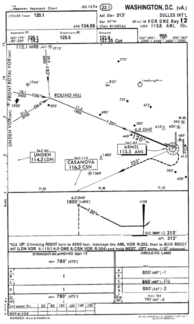
While the radial was coincident with the approach course, this was not an approach clearance. The feeder radials west of Round Hill had 3,000, 3,400, and 3,700 foot minimum altitudes. The captain, inexplicably, reasoned that since he wasn't on a feeder radial, he could disregard the minimum altitudes. (As if to reason the only terrain was under the feeder radials.)
The pilots again discussed the VOR/DME approach At 10:55, the landing preliminary checklist was read by the flight engineer and the other crewmembers responded to the calls. A reference speed of 127 kts was calculated and set on the airspeed indicator reference pointers. The altimeters were set at 29.74. The crew then again discussed items on the instrument approach chart including the Round Hill intersection, the final approach fix, the visual approach slope indicator and runway lights, and the airport diagram. At 10:59, the captain commented that the flight was descending from 11,000 feet to 8,000 feet. He then asked the controller if there were any weather obstructions between the flight and the airport. The controller replied that he did not see any significant weather along the route. The captain replied that the crew also did not see any weather on the aircraft weather radar.
Source: NTSB Aircraft Accident Report, AAR-75-16, ¶1.1
The published cockpit voice recorder transcripts begin at 11:04 so it is a mystery why the term "weather obstruction" went un-commented upon by the NTSB. They stated in the report, page 38, "The flightcrew believed that the controller would not clear them for the approach until they were clear of all obstructions." It is unclear how they know that, but the captain's actions bear it out, he started his descent to the final approach fix as soon as he received approach clearance.
- At 11:01, the controller cleared the flight to descend to and maintain 7,000 feet and to contact Dulles approach control. Twenty-six seconds later, the captain initiated a conversation with Dulles approach control and reported that the aircraft was descending from 10,000 feet to maintain 7,000 feet. He also reported having received the information "Charlie" transmitted on the ATIS broadcast.
- The controller replied with a clearance to proceed inbound to Armel and to expect a VOR/DME approach to runway 12. The controller then informed the crew that ATIS information Delta was current and read the data to them. The crew determined that the difference between information Charlie and Delta was the altimeter setting which was given in Delta as 29.70. There was no information on the CVR to indicate that the pilots reset their altimeters from 29.74.
- At 11:04, the flight reported it was level at 7,000 feet. Five seconds after receiving that report, the controller said, "TWA 514, you're cleared for a VOR/DME approach to runway 12." This clearance was acknowledged by the captain. The CVR recorded the sound of the landing gear warning horn followed by a comment from the captain that "Eighteen hundred is the bottom." The first officer then said, "Start down." The flight engineer said, "We're out here quite a ways. I better turn the heat down."
- At 11:05:06, the captain reviewed the field elevation, the minimum descent altitude, and the final approach fix and discussed the reason that no time to the missed approach point was published. At 11:06:15, the first officer commented that, "I hate the altitude jumping around. Then he commented that the instrument panel was bouncing around. At 11:06:15, the captain said, "We have a discrepancy in our VOR's, a little but not much." He continued, "Fly yours, not mine." At 11:06:27, the captain discussed the last reported ceiling and minimum descent altitude. He concluded, "...should break out."
Source: NTSB Aircraft Accident Report, AAR-75-16, ¶1.1
NTSB Aircraft Accident Report, AAR-75-16, Appendix F.
- At 11:06:42, the first officer said, "Gives you a headache after a while, watching this jumping around like that." At 11:07:27, he said, "...you can feel that wind down here now."
- A few seconds later, the captain said, "You know, according to this dumb sheet it says thirty four hundred to Round Hill --- is our minimum altitude." The flight engineer then asked where the captain saw that and the captain replied, "Well, here. Round Hill is eleven and a half DME."
- The first officer said, "Well, but ---" and the captain replied, "When he clears you, that means you can go to your ---" An unidentified voice said, "Initial approach, and another unidentified voice said, "Yeah!" Then the captain said "Initial approach altitude."
- The flight engineer then said, "We're out a --- twenty-eight for eighteen." An unidentified voice said, "Right, and someone said, "One to go."
- At 11:08:14, the flight engineer said, "Dark in here," and the first officer stated, "And bumpy too." At 11:08:25, the sound of an altitude alert horn was recorded. The captain said, "I had ground contact a minute ago," and the first officer replied, "Yeah, I did too." At 11:08:29, the first officer said, "...power on this.... " The captain said "Yeah --- you got a high sink rate." "Yeah," the first officer replied. An unidentified voice said, "We're going uphill, " and the flight engineer replied, "We're right there, we're on course." Two voices responded, "Yeah!" The captain then said, "You ought to see ground outside in just a minute -- Hang in there boy." The flight engineer said, "We're getting seasick."
- At 1108:57, the altitude alert sounded. Then the first officer said, "Boy, it was --- wanted to go right down through there, man," to which an unidentified voice replied, "Yeah!" Then the first officer said, "Must have had a # of a downdraft."
- At 1109:14, the radio altimeter warning horn sounded and stopped. The first officer said, "Boy!" At 11:09:20, the captain said, "Get some power on." The radio altimeter warning horn sounded again and stopped. At 11:09:22, the sound of impact was recorded.
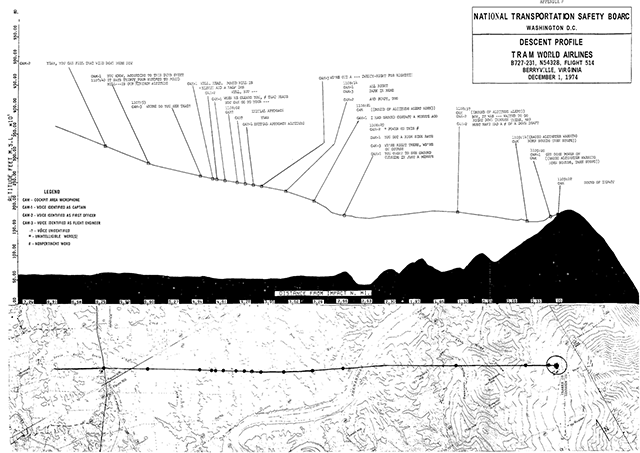
- After the aircraft left 7,000 feet, the descent was continuous with little rate variation until the indicated altitude was about 1,750 feet, increased about 150 feet over a 15-second period and then decreased about 200 feet during a 20-second period. The altitude The recorded altitude remained about 1,750 feet until the airplane impacted the west slope of Mount Weather, Virginia, about 25 nmi from Dulles, at an elevation of about 1,670 feet.
Source: NTSB Aircraft Accident Report, AAR-75-16, ¶1.1
3
Analysis
Controllers and pilots have available to them the same information regarding minimum sector altitudes within 25 miles of airports as well as minimum altitudes for various segments of an instrument approach.
Source: NTSB Aircraft Accident Report, AAR-75-16, ¶1.17
While the MSA presentation on the chart back then was not as user friendly it did indicate the minimum sector altitude from their direction was 3,300' out to 25 nautical miles. Of course they were beyond that distance while being below the altitude.
- The Jeppesen chart depicting the approach used by the crew of Flight 514 was based on the data published by the FAA on the Form 8260.5. However, there was no formal program of review or approval by the FAA in comparing the Jeppesen chart with the basic data on FAA Form 8260.5.
- The profile view of the VOR/DME approach to runway 12 at Dulles Airport, as published by NOS, depicted only the 6 DME fix and the final approach fix altitude of 1,800 feet. It did not depict the Round Hill intermediate approach fix altitude or the minimum altitudes associated with the routes inbound from the three initial approach fixes that were part of this procedure, although these data were displayed on the plan view. Form 8260.5 for this procedure did not list the requirement for the Round Hill intermediate fix to be included on the profile view.
- The FAA Terminal Air Traffic Control Manual 7110.8C, which was in effect on December 1, 1974, prescribed the air traffic control procedures and phraseology to be used by FAA personnel who provide terminal air traffic control services. [ . . . ] Section 9, Radar Arrivals, paragraph 1360, Arrival Instructions, contains the following guides for controllers regarding an aircraft before it reaches the approach gate, provided that the aircraft was not conducting a radar approach: "Issue. ..approach clearance, except when conducting a radar approach. If terrain or traffic does not permit unrestricted descent to lowest published altitude specified in approach procedure prior to final approach descent, controllers shall: (1) Defer issuance of approach clearance until there are no restrictions or, (2) Issue altitude restrictions with approach clearance specifying when or at what point unrestricted descent can be made . . ."
- The FAA witnesses testified that Flight 514 was inbound to Armel by means of the pilot's own navigation, thereby relieving the controller of responsibility under paragraph 1360 of the manual.
- The Airman's Information Manual (AIM) is designed to be a pilot's operational and information manual for use in the National Airspace System. [ . . . ] The February 1970 issue of the manual under the heading "Instrument Approach" states that upon receiving an approach clearance, the pilot should begin his descent to the "approach" altitude as soon as possible. This sentence was deleted in May 1970; however, the notation used to indicate a change was not published on that page. There is evidence to indicate that some pilots were not aware of this change.
- In 1967, the United States Air Force (USAF) questioned the FAA's procedures for instrument approaches with regard to the responsibility for terrain clearance. FAA responded that they would change the Air Traffic Control Handbooks to require the controller to include altitude information when approach clearances were issued. The change made to the manual did not require altitude restrictions on all approach clearances. Correspondence between the USAF and the FAA regarding this subject continued intermittently until December 11, 1974, when the FAA advised the USAF that a pilot should understand that, regardless of whether he is or is not receiving radar navigational guidance (except for a surveillance or precision radar approach) and regardless of the pilot's position when cleared for an approach, he is expected to remain at the last assigned altitude or descent not below the minimum en route altitude, transition altitude, or minimum obstruction clearance altitude and adhere to any remaining altitudes specified on the instrument approach plate while completing the instrument approach. Subsequently the USAF made an emergency change to AF Manual 51-37 which instructed military pilots that: "Once approach clearance has been received, maintain last assigned altitude until established on the published final approach course. The manual previously stated that a pilot under radar control, when cleared for a non-precision approach, could descend to the final approach fix altitude.
- About 1/2 hour before the accident, an air carrier flight approached Dulles from the northwest and was cleared for a VOR/DME approach to runway 12. The pilot of that flight said that because he was a considerable distance from the airport and was not given an altitude restriction to use before arriving on a published approach segment, he requested information regarding the minimum vectoring altitude at the flight's position. The controller gave the pilot the minimum vectoring altitude and offered the flight a surveillance radar approach. The captain accepted the surveillance approach and landed without further incident.
- About 6 hours after TWA 514's accident, a second air carrier aircraft approached Dulles from the southwest and at a point about 21 miles from Dulles, and asked the controller for the flight's position relative to the Round Hill intersection. The controller replied that he did not have Round Hill depicted on his radar. The captain later testified that he was familiar with the terrain around Dulles and did not descend until after he was on the inbound heading to runway 12 and inside 17.6 miles as indicated on his DME indicator.
Source: NTSB Aircraft Accident Report, AAR-75-16, ¶1.17
This is precisely what I was taught to do as an Air Force pilot, five years after this crash.
- Our review of the record supports the conclusion that the captain believed that when he approached the airport in a radar environment for a non-precision approach he would not be "cleared for the approach'' without an altitude restriction unless he could make an unrestricted descent to the final approach fix altitude.
- The volume of terminal air traffic has grown to the point that the FAA has frequently found it necessary to divert flights away from published instrument approach routes in order to improve the flow of traffic. In addition, it has become commonplace to clear pilots to descend below the altitudes published on the terminal area charts and instrument approach charts. Pilots in turn have tended to become more and more dependent on the air traffic controller to control their flight's altitudes, headings, and airspeeds. Concurrent with this increasing dependency has been (1) a lessened ability to know the type of terrain over which the aircraft is flying, and (2) in some cases, limited information regarding the position of the aircraft relative to the airport and obstacles on the ground.
- Both the USAF and TWA had pointed out to the FAA that the terminology "cleared for the approach" could be misinterpreted and that pilots might understand that they could descend unrestricted unless a specific altitude restriction was included in the clearance. With respect to the crew of TWA 514, the conversation in the cockpit as reflected in the CVR transcript permits no other conclusions than that they assumed the clearance received permitted an unrestricted descent to 1,800 feet.
- Considering the number of times the captain examined this chart after being informed that he was to divert to Dulles, he should have realized that the minimum altitude of 1,800 feet might not be a safe altitude. Although the captain did not know his exact position relative to the terrain when he received the approach clearance, the Board believes that with his VOR tuned to Armel and with the information provided by that navigational aid, he should have been able to read his DME range from Armel. At the time he received the clearance, he was about 44 nmi from Armel on the 300° radial inbound to the station. By reference to the approach chart, he should also have been able to identify the high obstacles between that position and the Round Hill intersection. With that information, he should have been able to determine that 1,800 feet was not an adequate altitude to provide terrain clearance of 2,000 feet in this designated mountainous area. If he did not realize that he was over a designated mountainous area, he should have applied terrain clearance of 1,000 feet as prescribed for nonmountainous areas. He did notice the 3,400 feet associated with the course between Front Royal and Round Hill. That should have suggested that he should reexamine his decision regarding the descent to 1,800 feet. If he had questioned the controller regarding the minimum altitude in the area of his aircraft, he should have received information that would have alerted him that he could not descend to 1,800 feet until after he passed Round Hill.
- The information available to the pilot, including the approach chart, should have alerted the crew that an unrestricted descent would be unsafe. It does appear to the Board that there was a deficiency in the chart. This particular approach chart depicted the profile view from the final approach fix to the airport. It did not depict the inter- mediate fix, Round Hill, with its associated minimum altitudes. This information was available from the plan view of the chart, but it appears that the crew gave their primary attention to the profile.
- The second major question deserving consideration is the role of the ATC system in this accident, specifically why TWA 514 was not given an altitude restriction in its approach clearance. The testimony of all FAA witnesses, including the controller, was consistent in stating that Flight 514 was not a "radar arrival;" that because of this fact the controller was not required to implement the provisions of paragraph 1360 of the FAA Handbook 7110.8C; and that they considered TWA 514, after intercepting the 300° radial of Armel, as proceeding on its own navigation and as being responsible for its own obstacle clearance.
- The counterposition is that Flight 514 was operating in a radar environment, was receiving at least one type of radar service, and was on a course which would lead directly to the Round Hill intermediate approach fix. Furthermore it had been advised that the reason for the vector to the 300° radial was for a VOR/DME approach for runway 12. Consequently, it should have received services, including altitude restrictions, as set forth in Paragraph 1360 of 7110.8C.
Source: NTSB Aircraft Accident Report, AAR-75-16, ¶2.1
4
Cause
- The National Transportation Safety Board determines that the probable cause of the accident was the crew's decision to descend to 1,800 feet before the aircraft had reached the approach segment where that minimum altitude applied. The crew's decision to descend was a result of inadequacies and lack of clarity in the air traffic control procedures which led to a misunderstanding on the part of the pilots and of the controllers regarding each other's responsibilities during operations in terminal areas under instrument meteorological conditions. Nevertheless, the examination of the plan view of the approach chart should have disclosed to the captain that a minimum altitude of 1,800 feet was not a safe altitude.
- Contributing factors were:
- The failure of the FAA to take timely action to resolve the confusion and misinterpretation of air traffic terminology although the Agency had been aware of the problem for several years;
- The issuance of the approach clearance when the flight was 44 miles from the airport on an unpublished route without clearly defined minimum altitudes; and
- Inadequate depiction of altitude restrictions on the profile view of the approach chart for the VOR/DME approach to runway 12 at Dulles International Airport.
Source: NTSB Aircraft Accident Report, AAR-75-16, ¶2.2.b.
References
(Source material)
NTSB Aircraft Accident Report, AAR-75-16, Trans World Airlines, Inc., Boeing 727-231, N54328, Berryville, Virginia, December 1, 1974.