Ah: good news, bad news. First the good: you no longer need two sets of codes, one for international and one for U.S. domestic. Now the bad: those codes are so complicated you can't possibly remember them all. Okay, I can't possible remember them. But even if you can, there is an easier way.
— James Albright


1
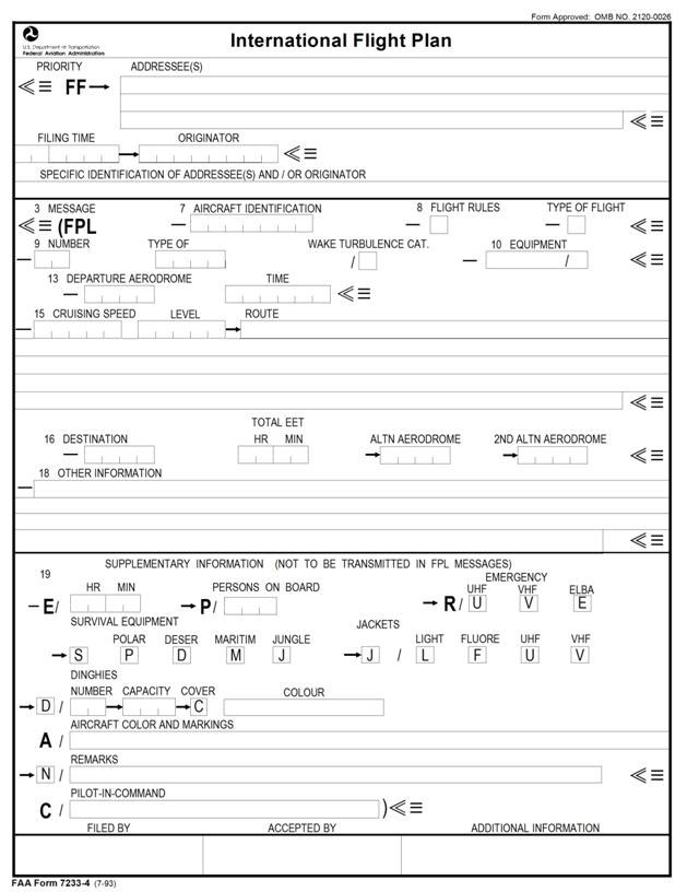
ICAO guidance
General
All clock times are in four figures, UTC.
All estimated elapsed times are in four figures (hours and minutes).
Area preceding Item 3 is to be completed by ATS and COM services.
If called upon to fill out an International Flight Plan you may wish to copy the filed flight plan portion of your computer flight plan as a guide.
Source: ICAO Doc 4444, Appendix 2
Instructions for Items 7 through 14
7. Aircraft Identification. Normally the aircraft call sign, if used, or the registration marking of the aircraft. (i.e., “TAG5”)
8. Flight Rules. “I” for IFR, “V” for VFR.
Type of Flight. “N” for non-scheduled air transportation operation, “G” for general aviation.
9. Number of Aircraft. Leave blank for one aircraft only.
Type of Aircraft. Designator as specified in ICAO Doc 8643. (i.e., “GLF5”)
Wake Turbulence Category. “H” if aircraft MTOW is greater than 136,000 kg, “M” if less than 136,000 kg but more than 7,000 kg, “L” if less than 7,000 kg.
Source: ICAO Doc 4444, Appendix 2
10. Equipment. (Changed as of 15 Nov 12)
Left of Slash
- S VHF, VOR, ILS
- B LPV
- D DME
- E2 D-FIS ACARS
- E3 PDC ACARS
- F ADF
- G GNSS
- H HF
- I IRS
- J3 CPDLC via FANS 1/A VDL Mode A
- J5 CPDLC vis FANS 1/A SATCOM (INMARSAT)
- M1 ATC SATCOM (INMARSAT)
- R PBN (requires remark in block 18)
- W RVSM
- X MNPS
- Y VHF with 8.33 spacing
- Z Other Com, Nav, or Dat (requires remark in block 18)
Right of Slash:
- H Mode S transponder with Flt ID, pressure altitude, enhanced surveillance
- I Mode S transponder with Flt ID, but no pressure altitude capability
- L Mode S transponder with Flt ID, pressure altitude, enhanced surveillance and ADS-B
- S Mode S transponder including both pressure altitude and Flt ID capability
- B1 ADS-B out via 1090 MHz
- D1 ADS-C via FANS 1/A
Source: ICAO Doc 4444, Appendix 2
The minimum to get across the North Atlantic and into Europe is: SXWGHRY/S.
For A Gulfstream G450 with enhanced navigation (Certification F-Enhanced): SBDE2E3FGHIJ3J5M1RWXYZ/HB1D1
13. Departure Aerodrome.
The four letter location identifier of the departure airport, or “ZZZZ” if no identifier (then specify airport in Item 18 with “DEP/” followed by name).
Source: ICAO Doc 4444, Appendix 2
Instructions for Items 15 through 19
15. Speed. Cruising Speed. Enter the “N” followed by four figures to specify true airspeed in knots (e.g., “N0485”), or “M” followed by three figures to specify true Mach Number (e.g., “M083”)
Cruising Level. Enter “F” followed by three figures to specify a flight level (e.g., “F450”), or “A” followed by three figures to specify altitude in hundreds of feet (e.g., “A100”)
Route. Flights along designated ATS routes. Insert the route designator if the departure airport is located on the route, otherwise insert “DCT” followed by the point of joining the first ATS route, followed by the designator of the route. Then, insert each point at which either a change of speed or level, a change of ATS route, and/or a change of flight rules is planned. Followed in each case by the designator of the next route segment, even if same as the previous one, or by “DCT” if the next point will be outside a designated route, unless both points are specified by geographic coordinates.
Flights outside designated ATS routes. Insert points normally not more than 30 minutes flying time or 200 nm apart, including each point at which a change of speed or level, a change of track, or a change of flight rules is planned. Insert “DCT” between successive points unless both points are defined by geographic coordinates or by bearing and distance.
ATS routes. The coded designator (2 to 7 characters), i.e., “UB10”.
Significant points. The coded designator (2 to 5 characters) of the assigned point, i.e., “HADDY”. Degrees only (7 characters) will be two figures describing latitude in degrees followed by “N” or “S” and three figures describing longitude in degrees followed by “E” or “W”, i.e., “46N078W”. Degrees and minutes (11 characters) will be four figures describing latitude in degrees and minutes followed by “N” or “S” and five figures describing longitude in degrees and minutes followed by “E” or “W”, i.e., “4620N07805W”. Bearing and distance from a navigation aid will be described by two or three characters, then the bearing in three figures (degrees magnetic), then the distance in three figures (nautical miles), i.e., “DUB180040”.
Change of speed or level (maximum 21 characters). The point at which a change of speed (5% TAS or 0.01 Mach or more) or a change of level is planned will be followed by an oblique stroke and both the cruising speed and cruising level without a space. I.e., “DUB180040/M082F330”.
16. Destination Aerodrome. The four letter ICAO location identifier or “ZZZZ” if no identifier (then specify airport in Item 18 with “DEST/” followed by name).
Total Elapsed Time. In four digits (hours and minutes).
Alternate Aerodrome. The four letter ICAO location identifier or “ZZZZ” if no identifier (then specify airport in Item 18 with “ALTN/” followed by name).
18. Other Information. As necessary.
- “EET/” (Significant points or FIR boundary designators and accumulated estimated elapsed time to such points.)
- “REG/” (Registration markings of the aircraft, if different from Item 7 aircraft identification.)
- “SEL/” (SELCAL code)
- “OPR/” (Name of operator, if not obvious from Item 7.)
- "NAV" Codes
- RNV RNAV
- A1 RNAV 1 arrival procedures
- D1 RNAV 1 departure procedures
- E2 RNAV 2 routes
- LPV LPV approach
Source: ICAO Doc 4444, Appendix 2
For A Gulfstream G450 with advanced NAV: RNVD1E2A1
- "PBN/" Performance Based Navigation codes:
- A1 RNAV 10, RNP 10
- B2 RNAV 5 via GNSS
- B3 RNAV 5 via DME/DME
- B4 RNAV 5 via VOR/DME
- C1 RNAV 2 via all permitted sensors
- D1 RNAV 1 via all permitted sensors
- L1 RNP 4 operations permitted
- O1 RNP 1 via all permitted sensors
- S2 GNSS Approach using Baro-VNAV
- T1 RNP AR Approach authorized
Source: ICAO Doc 4444, Appendix 2
B1 RNAV 5 via all permitted sensors (this wasn't in the cited ICAO doc but has been added since)
For A Gulfstream G450 with advanced PBN: B1C1D1L1O1S2
- “DAT/”
- S Datalink via SATCOM
- V Datalink via VHF
This used to specify the following, but the requirement has since been deprecated.
Source: ICAO Doc 4444, Appendix 2
For A Gulfstream G450 with advanced NAV the answer had been: DAT/SV, but that has since been deprecated. (You don't need it anymore.)
- “RMK/” (plain language remark.)
Source: ICAO Doc 4444, Appendix 2
The Gulfstream manuals say to add "RMK/AGCS EQUIPPED" here but you should not do that in a G450/G550 because it will prevent your "Acknowledge" reply.
For more about this see: CPDLC / Oceanc CLX.
2
FAA quick guide
The U.S. FAA provides a two-page quick guide for the proper ICAO Flight Plan Codes. It is very good but its location on the faa.gov website tends to move around. (As of this writing it is nowhere to be found.) The codes have been changing almost every year for about ten years now. The ICAO promises to knock that off and it appears they have kept to that promise for the last year:
-1.png)
FAA ICAO FPL Quick Guide, page 1
-2.png)
FAA ICAO FPL Quick Guide, page 2
3
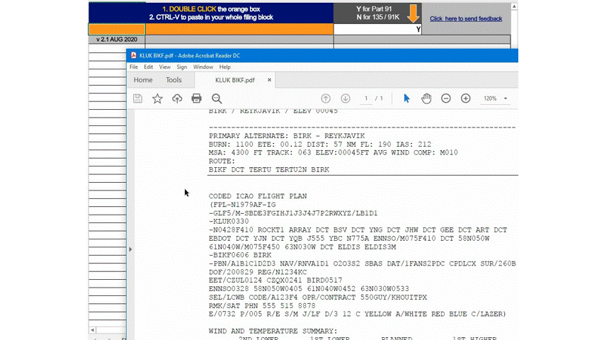
ICAO filing string decoder
The first time I ever filed an ICAO flight plan was in 1982 for a Boeing 707 (Air Force EC-135J) flying from Hawaii to Japan. As I recall, Block 10 of the filing string was five characters long, including an "S" for standard equipment, and four extra characters for our HF, VLF, INS, and TACAN. Our Block 18 only contained our Estimated Enroute Times (EETs) and a note about our diplomatic status. I had the Block 10 codes, all five of them, memorized. Fast forward to today and here is the Block 10 for a fully equipped Gulfstream GVII-G500:
SBDE2E3FGHIJ1J4J5J7M3P2RWXYZ/LB2D1
Besides the EETs and company specific notes, our Block 18 is:
PBN/A1B1C1D1L1O1S2 NAV/RNP2 DAT/1FANSP2PDC SUR/260B
Even after going through the pain of getting our LOAs for all this stuff, I still don't recognize most of these codes. Fortunately, Ed Lemelin has done the work for us. You can reach him by clicking on the top right link in the following spreadsheet.
The spreadsheet comes directly from him. You can check the source material given in the References given below.
Start by double-clicking the orange cell, then paste in your filing string.
Disclaimer
This tool is designed to help find errors in your ICAO filing strip and to show OPSPEC/LOA requirements as we understand them as of July 2020. It is your responsibility to verify the accuracy of any information presented here. Always double check your filing strip to ensure you're actually filed for what you think you're filed for.
— Ed Lemelin
Click here for instructions: Decoder Instructions.
References
(Source material)
Please note: Gulfstream Aerospace Corporation has no affiliation or connection whatsoever with this website, and Gulfstream does not review, endorse, or approve any of the content included on the site. As a result, Gulfstream is not responsible or liable for your use of any materials or information obtained from this site.