Perhaps reading a compass is about as simple a task as required of any pilot, there just isn't that much to it.
— James Albright

Updated:
2014-03-26
But, in case a refresher is needed, here it is.

1
The numerical system for determining direction
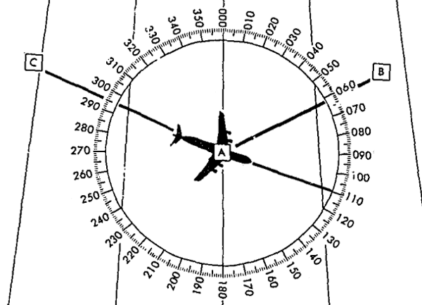
Numerical direction system,
(AFM 51-40, figure 2-8)
- The numerical system, [shown in the figure], divides the horizon into 360 degrees starting with north at 000 degrees, south 180 degrees, west 270 degrees, and back to north.
- The circle, called a compass rose, represents the horizon divided into 360 degrees. The nearly vertical lines in the illustration are meridians of position A passing through 000 degrees and 180 degrees of the compass rose. Position B lies at a true direction of 062 degrees from A, and position C is at a true direction of 295 degrees from A.
- Course is the intended horizontal direction of travel.
- Heading is the horizontal direction in which an aircraft is pointed. Heading is the actual orientation of the longitudinal axis of the aircraft at any instant, while course is the direction intended to be made good.
- Track is the actual horizontal direction made by the aircraft over the earth.
- Bearing is the horizontal direction of one terrestrial point from another.
Source: AFM 51-40, pages 2-5 to 2-6.
2
True course
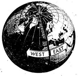
Longitude East and West of Greenwich Meridian,
(AFM 51-40, figure 2-5
A "True Course" is the relative bearing between your course and true north. It is usually found by placing a plotter over a chart and reading the angular difference to any meridian. More about this: Coordinates.
3
Variation
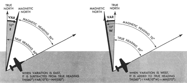
Variation, (AFM 51-37, page 1-13)
The magnetic compass points to magnetic north. The angular difference between true and magnetic north is known as variation and it changes for different locations on the earth. Variation must be considered when converting true course, true headings, or true winds to magnetic direction.
Source: AFM 51-37, page 1-12.
This can be considered an academic exercise in understanding the difference between TRUE and MAGNETIC, except for anyone who flies at high latitudes where magnetic navigation is unreliable, or anyone who flies in Class II or oceanic airspace where plotting procedures are required. If you ever need to plot a position, variation is critical. More:
Variation is measured in degrees and direction either east or west. Westerly variation is positive, easterly is negative.
4
Deviation
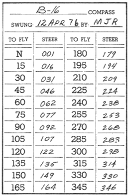
Compass correction card,
(AFM 51-37, figure 1-15)
Deviation [is] an error in compass indications caused by magnetic disturbances originating within the aircraft. The magnitude of deviation varies with operation of different electrical equipment. Periodically, the compass is checked and and compensations are made to reduce the amount of deviation. Deviation errors remaining after the compass has been checked are recorded on a compass correction card in the cockpit. The STEER column on the compass correction card is the compass heading you should indicate to maintain the TO FLY magnetic heading.
Source: AFM 51-37, page 1-12.
At Air Force Instrument Instructor's school we were taught to fly IFR off nothing more than an attitude indicator and a magnetic compass. I came to the conclusion it would be safer to declare an emergency and get no gyro vectors. These days the chances of needing to fly off one of these cards are remote, but you should know how.
Deviation is given as degrees to steer to accomplish a desired heading, but can be thought of as positive and negative numbers to apply a magnetic heading.
5
True / magnetic course
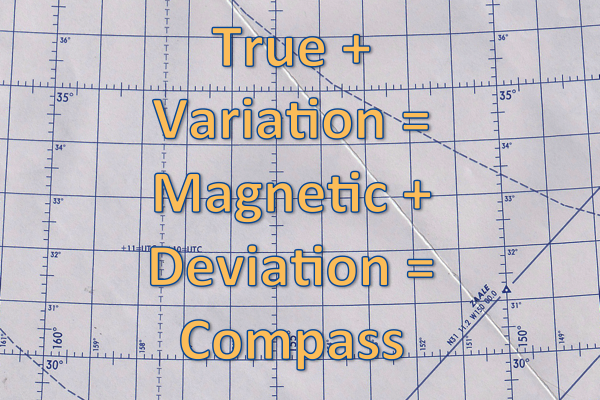
The navigator's text above hints at complications we pilots didn't want, so they gave us an old sailor's mnemonic: "True virgins make dull company" to which others added "Add Whiskey." Still others add "east is least, west is best" to remember which direction gets added and which gets subtracted. Crude or not, the idea was to remember the order in which things are added to a true course to end up with what the sailor (and pilot) wanted, which was a course to sail (and fly). To wit:
- Start with a TRUE course using your handy plotter, to that you add
- magnetic VARIATION (explained: above) to get a
- MAGNETIC course; to that add
- DEVIATION (explained: above) to get a
- COMPASS heading to steer.
The "Add Whiskey" part was to help us remember we add west variation and deviation while subtracting east variation and deviation.
References
(Source material)
Air Force Manual (AFM) 51-37, Instrument Flying, 1 December 1976
Air Force Manual (AFM) 51-40, Air Navigation, Flying Training, 1 July 1973
World Geodetic System 1984, Department of Defense, National Imagery and Mapping Agency (NIMA), NSN 7643-01-402-0347, NIMA TR8350.2, Third Edition, Amendment 1, 3 January 2000