This crew dialed the ILS frequency in the standby position while using the VOR for long range navigation, both neglected to select the ILS frequency prior to starting the approach. When they were unable to select APR with their flight directors, the failed to investigate why. The pilot then started to fly the VOR as if it were the localizer. The airplane's EADI had the fast/slow pointer on the left and the glide slope pointer on the right, both presented in the same color. The pilot's mistakenly saw the fast/slow pointer as the glide slope and descended well short of the runway. The first officer realized his failure to switch frequencies about a minute prior to impact and failed to call for a go around. The pilot had exceeded 1,000 fpm descent while following the fast/slow pointer as if it were the glide slope pointer.
— James Albright

Updated:
2012-04-06
The NTSB concluded both pilots were killed because they failed to cross check the ILS frequency and that is definitely true. But they also violated stabilized approach criteria which would have dictated a go-around at 1,000 feet in instrument conditions.

1
Accident report
- Date: 22 NOV 2004
- Time: 06:15
- Type: Gulfstream Aerospace G-1159A Gulfstream III
- Operator: Business Jet Services
- Registration: N85VT
- Fatalities: 3 of 3 crew
- Aircraft Fate: Destroyed
- Phase: Approach
- Airports: (Departure) Dallas-Love Field, TX (DAL) (DAL/KDAL), United States of America; (Destination) Houston-William P. Hobby Airport, TX (HOU) (HOU/KHOU), United States of America
2
Narrative
- On November 22, 2004, about 0615 central standard time, a Gulfstream G-1159A (G-III), N85VT, operated by Business Jet Services Ltd., struck a light pole and crashed about 3 miles southwest of William P. Hobby Airport (HOU), Houston, Texas, while on an instrument landing system (ILS) approach to runway 4. The two pilots and the flight attendant were killed, an individual in a vehicle near the airport received minor injuries, and the airplane was destroyed by impact forces. The airplane was being operated under the provisions of 14 Code of Federal Regulations (CFR) Part 91 on an instrument flight rules flight plan. Instrument meteorological conditions (IMC) prevailed at the time of the accident.
- The accident flight was scheduled to depart from Dallas Love Field Airport (DAL), Dallas, Texas, about 0500 as a positioning flight to HOU. The flight crew planned to pick up former President George H.W. Bush and other passengers at HOU and transport them to Guayaquil, Ecuador. The flight was scheduled to depart HOU about 0654. The flight departed DAL about 0530. According to Business Jet Services Flight Operations and Charter Sales Manager, the departure was delayed because of poor weather conditions at HOU and DAL. The captain was the flying pilot, and the first officer performed the nonflying pilot duties.
- At 0543:32, the flight crew received HOU automatic terminal information service (ATIS) information "Quebec," which reported that the winds were calm, the visibility was 1/8 statute mile (sm) in fog, the runway visual range (RVR) for runway 4 was variable between 1,600 and 2,400 feet, and the clouds were broken at 100 feet and overcast at 9,000 feet. At 0547:50, the cockpit voice recorder (CVR) recorded the first officer starting the approach briefing. About 3 minutes later, the CVR recorded a discussion between the pilots about entering the navigational approach fixes CARCO, ELREN, EISEN, and Hobby (HUB) very high frequency omnidirectional range (VOR) in the airplane's flight management system (FMS). The captain asked, "we can probably delete HUB though, can't we?" The first officer replied, "yeah, we could 'cause we're gonna have that on here for our missed [approach point]." (See figure 1 for the runway 4 ILS published approach chart.)
Source: NTSB AAB-06/06
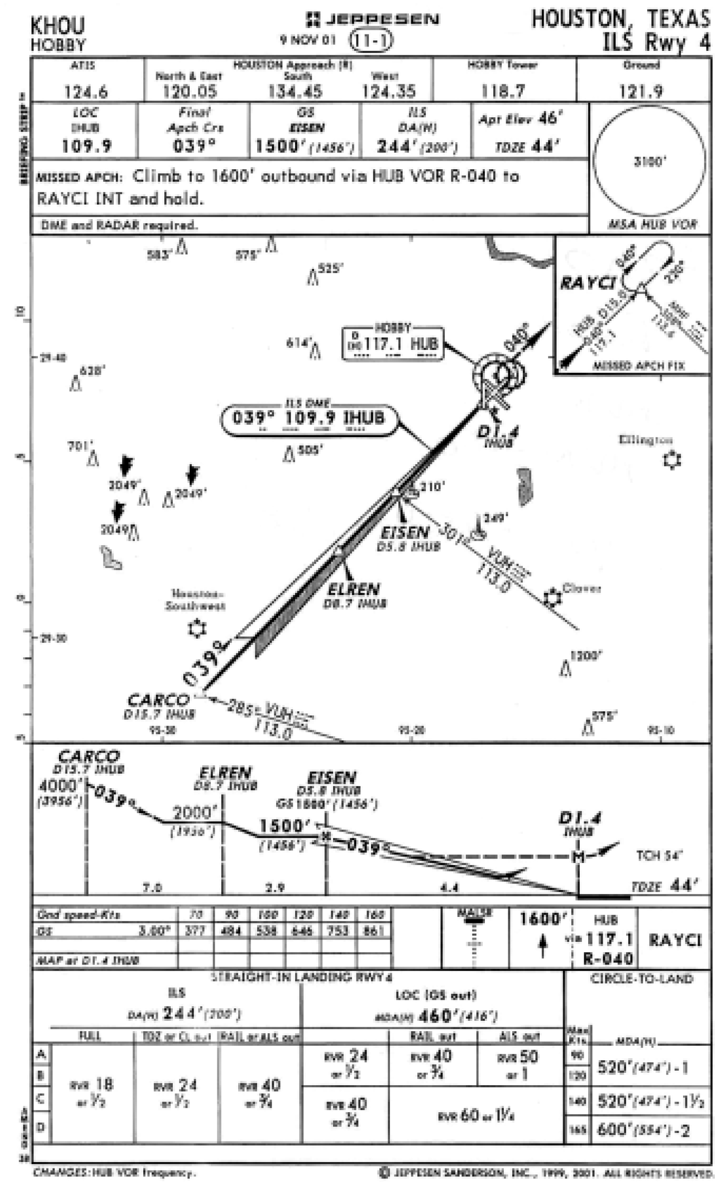
ILS Runway 4, NTSB AAB-06/06, figure 1
- At 0558:50, the first officer contacted the Houston Terminal Radar Approach Control (TRACON) and reported, "approach . . . Gulfstream eight five Victor Tango's with you out of one eight zero for one one thousand [feet], [ATIS] information 'Kilo.' The controller cleared the flight directly to CARCO, adding, "when you're able for the ILS runway four." The first officer acknowledged the transmission; however, he read back, "ILS runway one four" instead of "runway four." He then stated, "I'll set up our ILS, in here, one oh nine nine."
- At 0605:05, the Houston TRACON controller instructed the flight crew to descend to and maintain 3,000 feet. Radar data indicated that, about this time, the airplane was at an altitude of about 11,000 feet and was located about 29 miles northwest of HOU. At 0609:33, the first officer started the before landing checklist, and, about 1 minute later, he stated, "five miles . . . from CARCO." At 0610:43, the controller instructed the flight crew to turn left heading 070° and to maintain an altitude of "2,000 feet or above 'til established [on the] localizer." The controller then cleared the flight for the ILS runway 4 approach. At 0611:13, the first officer stated, "localizer's alive." (See figure 2 for the accident airplane's ground track.)
Source: NTSB AAB-06/06
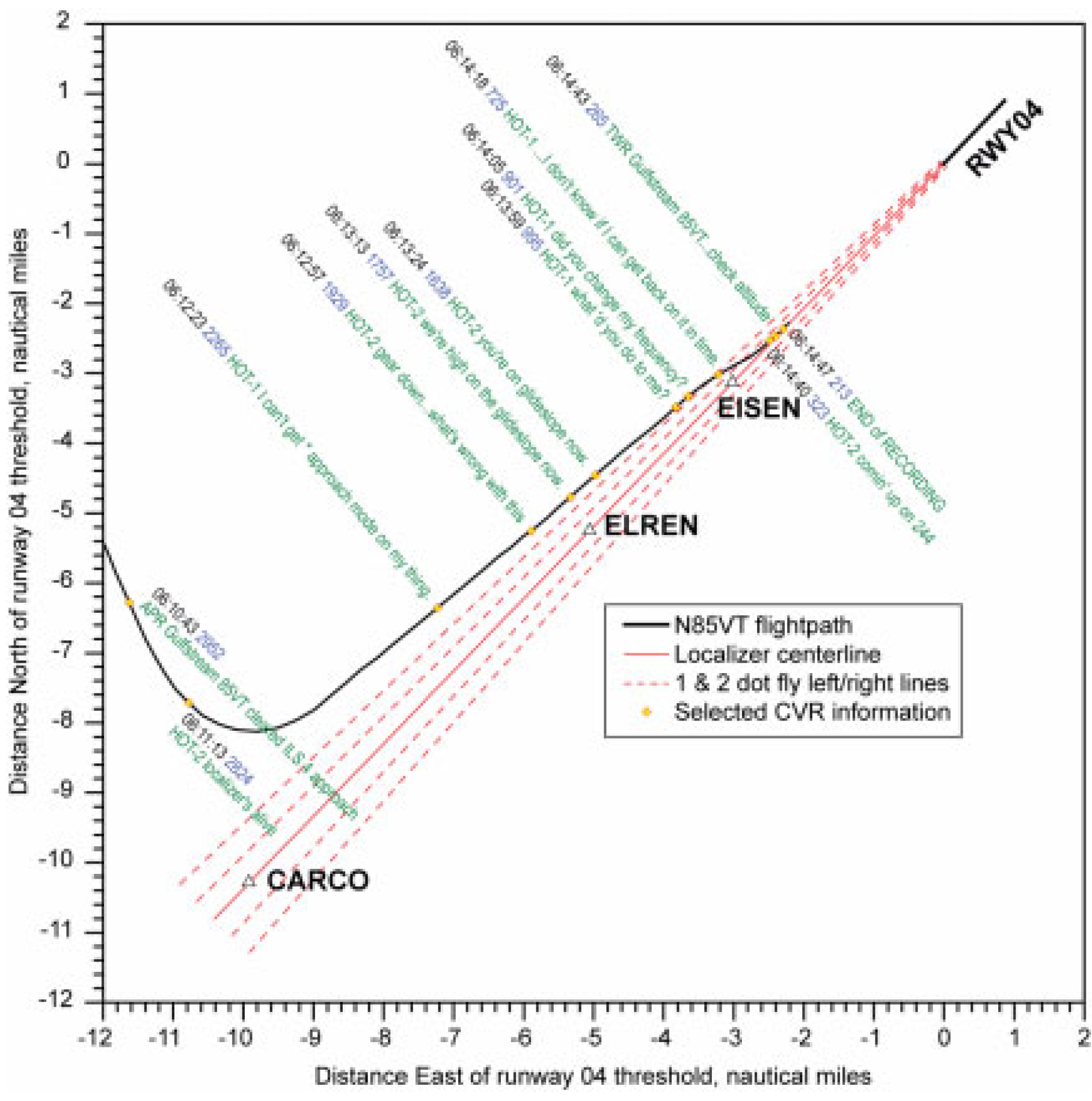
Airplane's ground track, NTSB AAB-06/06, figure 2.
- An airplane performance study conducted by the National Transportation Safety Board indicated that, about 0611, the airplane was descending through an altitude of about 2,900 feet on a southeasterly heading when it started turning left to converge on the ILS localizer. The airplane continued descending during the inbound turn and leveled off at an altitude of about 2,300 feet. At 0611:41, the Houston TRACON controller instructed the flight crew to contact the HOU air traffic control tower (ATCT). About 16 seconds later, the first officer contacted the HOU ATCT and stated, "with you on the ILS." The ATCT controller reported calm winds and then cleared the flight to land on runway 4. The performance study indicated that, about this time, the airplane was still at an altitude of about 2,300 feet and was located about 11 miles southwest of HOU.
- At 0612:15, the captain asked the first officer to get the RVR. He then stated, "I can't get approach [APR] mode on my thing." The first officer replied that he could not get the APR mode to activate either. About 0613, the airplane descended through 2,000 feet. The airplane performance study showed that the airplane was about 1,000 feet below the glideslope about this time and that the airplane remained 600 to 1,000 feet below the glideslope until impact.
- At 0612:31, the HOU ATCT controller reported to the first officer that the RVR was 1,600 feet. The first officer acknowledged the transmission. At 0612:40, the first officer stated, "gear down." At 0612:57, the first officer asked, "what [is] . . . wrong with this?" The captain responded, "I don't know." At 0613:03, the first officer further asked, "what do we have set wrong? we have . . . long range [navigation or NAV] or something . . . that we shouldn't have?" Five seconds later, the captain reported, "got NAV . . . VOR one."" The first officer stated, "okay, we're high on the glideslope now," and the captain replied, "just gonna have to do it this way." At 0613:24, the first officer stated, "guess so. yeah you're on [the] glideslope now." However, the airplane performance study showed that, about the time that the first officer made the comments about the glideslope, the airplane was at an altitude of about 1,700 feet and was 700 feet below the glideslope. (See figure 3 for the accident airplane's altitude profile.)
Source: NTSB AAB-06/06
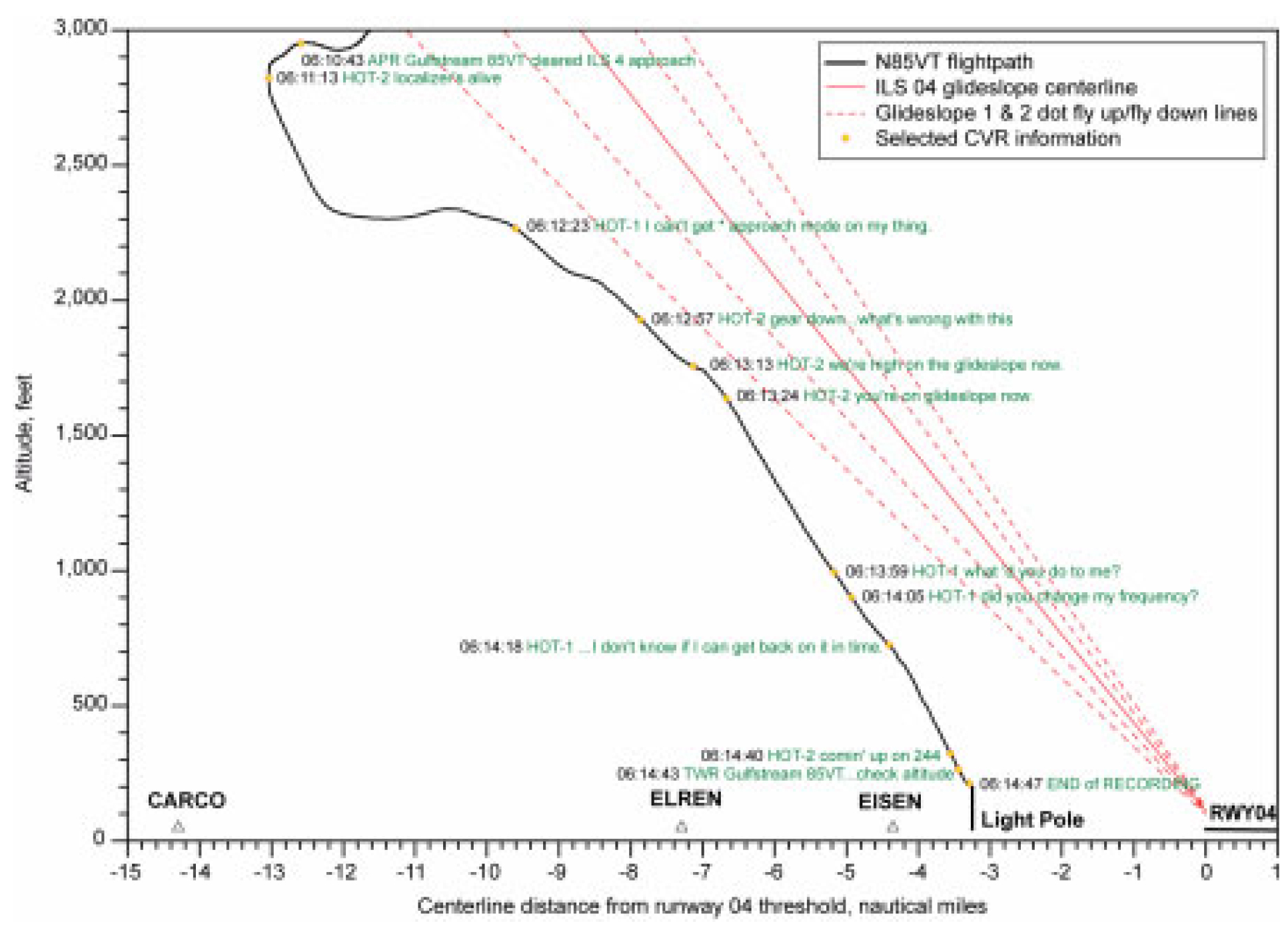
Airplane's altitude profile, NTSB AAB-06/06, figure 3.
- At 0613:44, the captain asked the first officer if they were going to descend to an altitude of 244 feet, and the first officer replied, "yeah." The airplane performance study indicated that, about 0614, the airplane was at an altitude of about 1,000 feet. At 0614:05, the captain asked, "what happened? did you change my frequency?" The first officer responded, "yeah we were down there . . . the VOR frequency was on." He then stated, "we're all squared away now . . . you got it." The captain responded, "yeah, but I, I don't know if I can get back on it in time." The first officer replied, "yeah you will . . . you're squared away now." The airplane performance study showed that, shortly after the captain's question regarding the frequency, the airplane turned right and subsequently intersected the ILS runway 4 localizer centerline. As shown in figure 3, about this time, the airplane was at an altitude of about 900 feet and was 800 feet below the glideslope.
- The airplane performance study showed that the airplane tracked the ILS runway 4 localizer and continued to descend until about 0614:47. The airplane impacted a light pole at an altitude of about 198 feet and about 3 1/4 miles from the runway 4 threshold.
At 0614:32, the first officer stated, "I'm, I'm outside," and, 8 seconds later, he stated, "okay, comin' up on two forty four." At 0614:35, the automated radar terminal system minimum safe altitude warning (MSAW) provided visual and aural warnings to the Houston TRACON and HOU ATCT controllers. At 0614:42, the captain completed the before landing checklist, stating, "give me full flaps." " At 0614:45.2, the CVR recorded the first officer state, "up," seven times in quick succession. The CVR recorded the HOU ATCT controller simultaneously state, "check your altitude, altitude indicates four hundred feet." The flight crew did not respond to the controller's transmission. No further communications were received from the flight crew.
Source: NTSB AAB-06/06
3
Analysis
- The airplane was equipped with an electronic flight instrument system (EFIS), which consisted of two electronic displays, a symbol generator, a display controller, and a source controller. The electronic attitude director indicator (EADI) has a fast/slow indicator that is always visible and a glideslope indicator that is only visible when a valid ILS frequency has been selected. If a valid frequency has not been selected, the side of the screen where the glideslope indicator should appear remains blank. The fast/slow indicator shows airspeed guidance relative to a target airspeed, and the glideslope indicator shows aircraft vertical deviation from the ILS glideslope.
- The glideslope and fast/slow indicators are the same color and about the same size. Each indicator consists of a moving pointer on a rectangular display, and each display has markers above and below the rectangle to indicate the degree of deviation. The glideslope pointer resembles a blunt-point arrow, and the fast/slow pointer resembles a rectangle (see figure 4). The accident airplane's EADI was configured with the glideslope indicator on the left side and the fast/slow indicator on the right side.12 A review of the Safety Board's accident database revealed no instances of accidents involving confusion of a different cockpit instrument with the glideslope indicator.
12 FAA Advisory Circular (AC) 25-11, "Transport Category Airplane Electronic Display Systems," dated July 16, 1987, provides guidance on the location of essential flight instrument displays, including the glideslope indicator. The AC recommends standardizing the location of the glideslope indicator to the right side of the main display; however, the accident airplane was manufactured before this guidance was issued. Five other company airplanes flown by the accident pilots were configured with the glideslope indicator on the left side. Of these airplanes, four had fast/slow indicators on the right side, and one had no indicator on the right side. Three of the company airplanes flown by the accident pilots had the glideslope on the right side.
Source: NTSB AAB-06/06, pp. 9 - 10
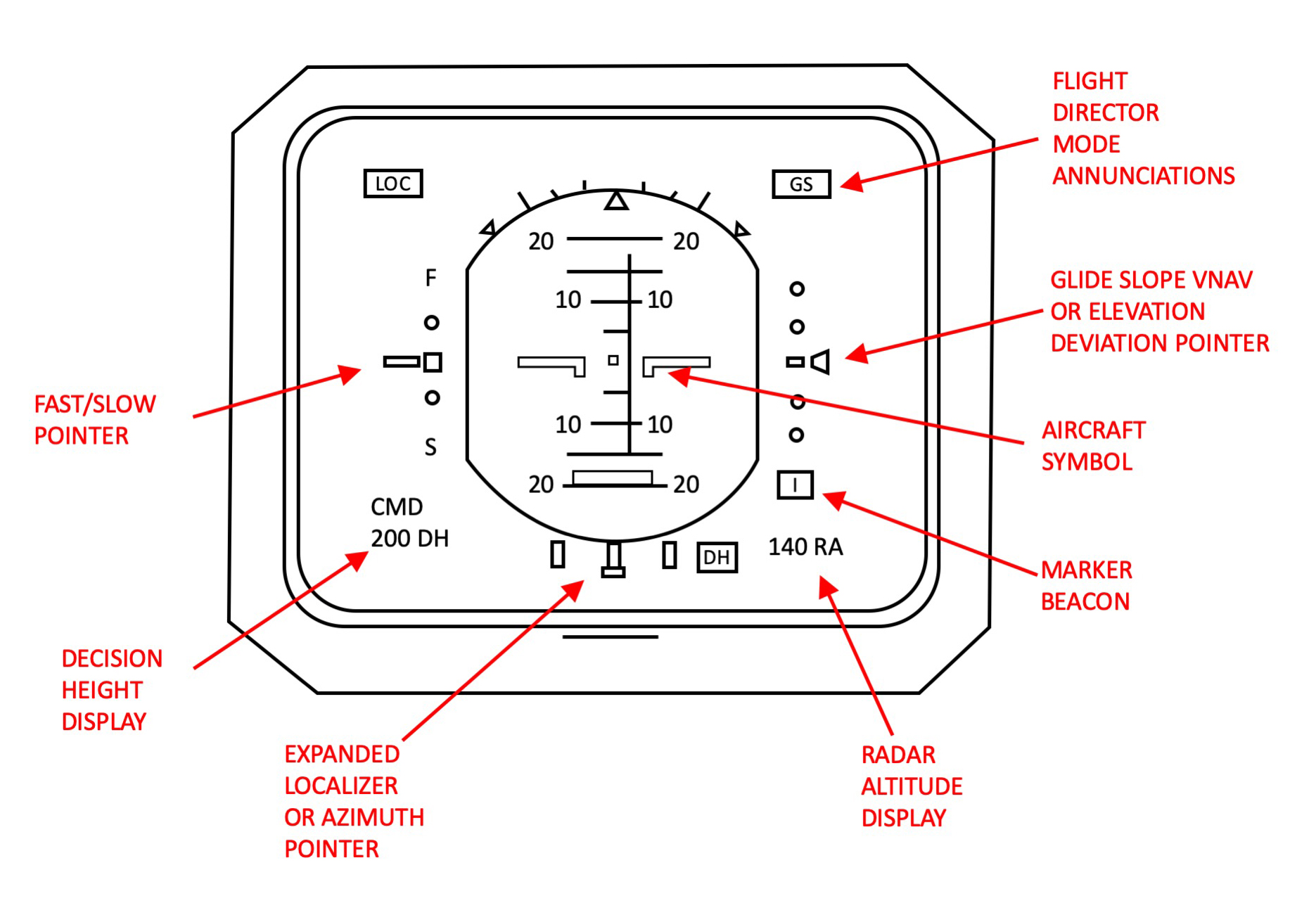
NTSB AAB-06/06, figure 4.
Postaccident benchtests set to parameters approximating the accident flight profile showed that the "glideslope," "500" foot, "too low terrain," "minimums," "300" foot, and "200" foot GPWS alerts should have activated on the accident flight. However, the CVR did not record the accident GPWS generate any alerts during the flight. The only common failure that could prevent activation of the GPWS glideslope and altitude callouts is a radio altimeter failure. However, a review of Business Jet Services' maintenance records and the CVR transcript found no evidence indicating any problems with the radio altimeter. The GPWS unit and the radio altimeter were destroyed during impact; therefore, the Safety Board was unable to determine why the GPWS did not operate as expected. Federal regulations would have required that the accident airplane be equipped with an EGPWS by March 29, 2005. The EGPWS provides pilots with a pictorial view of terrain in addition to aural alerts.
Source: NTSB AAB-06/06, p. 18
- About 3 minutes after starting the approach briefing, the CVR recorded the captain asking the first officer to set the navigational approach waypoints in the FMS. The pilots then discussed deleting the HUB VOR waypoint from the list, which the first officer most likely did at that time. The MFD only displays a chronological number for each approach waypoint; therefore, it is possible that the flight crew forgot that the first officer removed the HUB waypoint from the FMS, causing them to mistakenly believe that the last waypoint displayed on the MFD (EISEN) was the airport. Regardless, an FMS serves as a secondary navigational aid on an ILS approach. The pilots should have been relying on the primary navigational aids during the approach.
- About 0612, the CVR recorded both pilots stating that they were unable to get the APR mode on their flight directors to activate. About 1 minute later, the first officer told the captain that they were "high on" the glideslope and then that they were "on" the glideslope. According to the airplane performance study, the airplane was actually about 700 feet below the glideslope when the first officer made these statements, and the airplane remained well below the glideslope throughout the rest of the approach. Although the first officer entered the ILS frequency in the standby position in both VHF NAV receivers earlier in the approach (about 0559, after the approach clearance), at this point in the approach, neither pilot had selected the ILS frequency. Further, the glideslope indicator would not have been visible on the EADI. Therefore, the first officer could not have been looking at the glideslope indicator when he made the statements about the glideslope.
- The first officer's failure to activate and identify the ILS frequency earlier in the approach prevented the flight crew from recognizing that the airplane was off course and below the glideslope. The fast/slow indicator on the EADI resembles the glideslope indicator and is visible on the EADI at all times, whereas the glideslope indicator only appears on the screen once an ILS frequency has been activated. Postaccident flight simulations revealed that the fast/slow indicator would have been centered within one dot during the approach sequence and that the indications would have been consistent with the first officer's comments about the glideslope if he had mistaken the fast/slow indicator for the glideslope indicator.
- The first officer did not switch the VOR frequency to the ILS frequency until about 1 minute before impact. When the first officer realized that he had not switched to the ILS frequency, he should have called for a missed approach because the airplane was not properly configured for the approach and was not receiving proper vertical guidance during the most critical phase of the flight. Once the first officer selected the ILS frequency, the glideslope indicator would have appeared on the screen and both pilots' displays would have shown a full-scale deviation below the glideslope and a full-scale or near full-scale deviation of the localizer; however, the CVR did not record either pilot mention the glideslope deviation. The fast/slow indicator would have remained visible on the EADI even after the ILS frequency was selected, which may explain why the pilots did not immediately notice the glideslope indicator deviation after the first officer selected the ILS frequency. Therefore, the pilots most likely mistook the fast/slow indicator for the glideslope indicator throughout the approach sequence.
- Shortly after activating the ILS frequency, the first officer stated, "we're all squared away now." The captain replied, "I don't know if I can get back on it [the ILS localizer] in time." The first officer stated, "yeah you will. you're squared away now." These comments indicate that the pilots were focused on correcting the localizer deviation. The first officer dismissed the captain's concerns, and the captain did not proceed to assert his authority. As noted, earlier in the approach, the flight crew had attempted unsuccessfully to activate the flight director APR mode, and no evidence indicates that either pilot tried to reactivate the APR mode on their flight directors once the ILS frequency was selected. Therefore, the flight crew continued to perform the approach without the advantage of flight director guidance. The CVR did not record the pilots making any of the required altitude callouts, except at 0614:40, when the first officer announced that they had reached the DH of 244 feet. The airplane hit the light pole immediately thereafter.
Source: NTSB AAB-06/06, pp. 19 - 20
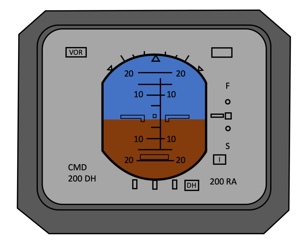
If you fly several aircraft with differing cockpits you should worry about this. Fortunately the presentation of information on Pilot Flight Displays are better standardized these days but we still have differences. Most aircraft these days are equipped with the glide slope pointer on the right side of the display and the fast/slow indicator on the left, in accordance with AC 25-11. Note that the glide slope indicator does not appear unless a valid ILS frequency with a glide slope is selected. The following is just such a "normal" display with the aircraft on speed (F/S pointer centered) and an ILS tuned with the glide slope centered.
On glide slope and on speed with the speed deviation indicator left side, glide slope indicator right side.
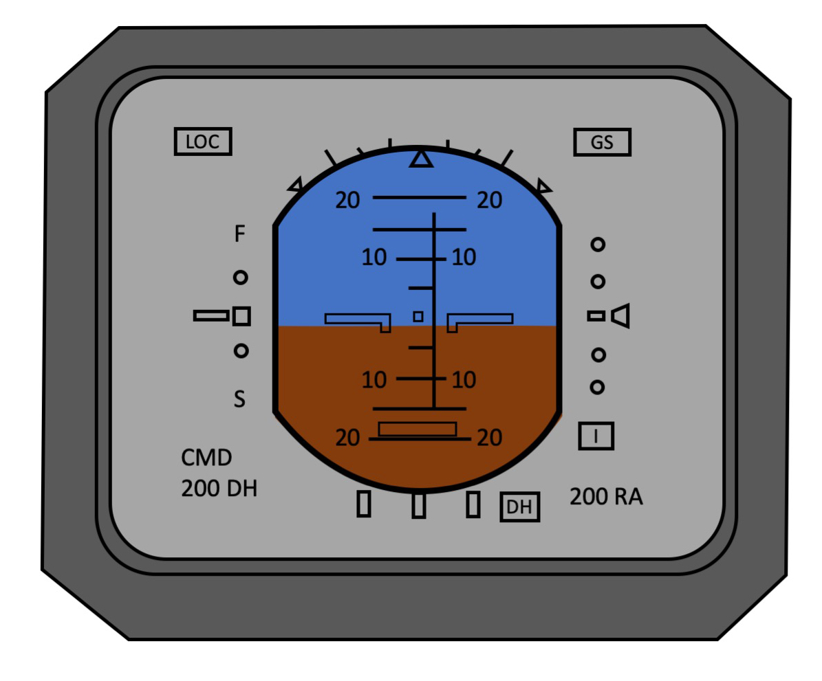
The accident pilots flew a mix of aircraft, most of which (but not all) configured opposite to the recommended layout. N85VT was of this type and had the glide slope indicator on the left with the fast/slow indicator on the right. Since they started the approach with the VOR tuned, the glide slope indicator was not in view. So assuming they were on speed, the would have seen something like this:
On speed and no localizer tuned with the speed deviation indicator right side, glide slope indicator left side but not in view.
Of course they made a lot of mistakes and should have noticed the absence of the LOC status bar. But at a quick glance the indicator on the right could have been confused for a glide slope indicator.
4
Cause
"The National Transportation Safety Board determines that the probable cause of this accident was the flight crew’s failure to adequately monitor and cross-check the flight instruments during the approach. Contributing to the accident was the flight crew’s failure to select the instrument landing system frequency in a timely manner and to adhere to approved company approach procedures, including the stabilized approach criteria."
Source: NTSB AAB-06/06, p. 21
References
(Source material)
NTSB Aircraft Accident Brief, AAB-06/06, Crash During Approach to Landing, Business Jet Services, Ltd., Gulfstream G-1159A (GIII), N85VT, Houston, Texas, November 22, 2004.