A lot of rules for using GPS have changed over the years and what you can and cannot do also depends on where in the world you are. Things are becoming more and more standardized, but you still need to be careful.
— James Albright

Updated:
2020-12-09
For example, can you an approach in the U.S. that is titled "VOR Rwy 23" using GPS? No, the U.S. overlay program that said you could a few years ago was in Advisory Circular 90-94 which was cancelled in 2009. In the U.S., the approach has to have the term "GPS" in the title. What about the "VOR DME Rwy 31" to Sibu, Malaysia? Yes, they are WGS-84 compliant and ICAO rules say you can. In the case of the U.S. approach, it would be a good idea to have the GPS up for position awareness and in Malaysia you should probably have the VOR up for back up.
What about an approach that references GNSS and not GPS? Well, it depends. If your airplane lists it as a viable approach, if the country is WGS-84 compliant, and if the country's rules allow you to, then probably. It is a confusing world out there.
5 — U.S. / ICAO Requirements to use GPS
6 — Receiver Autonomous Integrity Monitoring (RAIM)
7 — Fault Detection and Exclusion (FDE) and NOTAMS

1
Overview

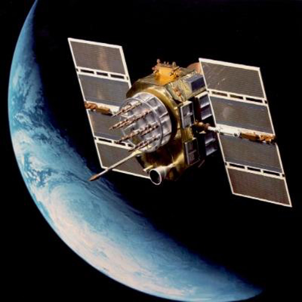
GPS Constellation,
AFAIS
- The Department of Defense (DOD) developed and deployed GPS as a space-based positioning, velocity, and time system. The DOD is responsible for the operation the GPS satellite constellation and constantly monitors the satellites to ensure proper operation. The GPS system permits Earth-centered coordinates to be determined and provides aircraft position referenced to the DOD World Geodetic System of 1984 (WGS-84). Satellite navigation systems are unaffected by weather and provide global navigation coverage that fully meets the civil requirements for use as the primary means of navigation in oceanic airspace and certain remote areas. Properly certified GPS equipment may be used as a supplemental means of IFR navigation for domestic en route, terminal operations, and certain IAPs. Navigational values, such as distance and bearing to a waypoint and groundspeed, are computed from the aircraft's current position (latitude and longitude) and the location of the next waypoint. Course guidance is provided as a linear deviation from the desired track of a Great Circle route between defined waypoints.
- The space element [of GPS] consists of 24 Navstar satellites. This group of satellites is called a constellation. The satellites are in six orbital planes (with four in each plane) at about 11,000 miles above the Earth. At least five satellites are in view at all times. The GPS constellation broadcasts a pseudo-random code timing signal and data message that the aircraft equipment processes to obtain satellite position and status data. By knowing the precise location of each satellite and precisely matching timing with the atomic clocks on the satellites, the aircraft receiver/processor can accurately measure the time each signal takes to arrive at the receiver and, therefore, determine aircraft position.
Source: FAA Instrument Handbook, pg. 7-21
2
How GPS works
There is obviously much more to it than what follows, but this gives you what you need to understand how GPS has changed the way we fly airplanes. . .
The Transmitted Signal
NAVSTAR-2, from Lockheed-Martin
The U.S. Global Positioning System (Also called "Navstar") consists of 24 operational satellites (plus a few spares) of which 5 to 8 should be in view anywhere on the earth. They are at 11,000 nautical miles in altitude and complete an orbit every 12 hours.
Each Navstar satellite transmits on two frequencies:
- L1: 1575.42 MHz — C/A and P codes
- L2: 1227.6 MHz — P code only
Coarse Acquisition (C/A) code is available to all users without limitations and includes
- Ephemeris (position, altitude, speed information from the satellite)
- Time (from the onboard atomic clock, including a time correction factor to make up for the clock's internal errors)
- Satellite health status
- GPS Almanac (predicted positions for entire GPS constellation, often good for months). A receiver that keeps the almanac in memory can predict from a cold start where to look for satellites, speeding acquisition times.
P-Code provides navigation/targeting data for U.S. government users with an encryption key
- Position data
- Broadcast on both frequencies, allowing qualified receivers to compare both frequencies and correct for any ionospheric delays.
- Once decrypted P-code becomes Y-code.
The aircraft GPS receiver measures distance from a satellite using the travel time of a radio signal. Each satellite transmits a specific code, called a course/acquisition (CA) code, which contains information on the satellite's position, the GPS system time, and the health and accuracy of the transmitted data. Knowing the speed at which the signal traveled (approximately 186,000 miles per second) and the exact broadcast time, the distance traveled by the signal can be computed from the arrival time. The distance derived from this method of computing distance is called a pseudo-range because it is not a direct measurement of distance, but a measurement based on time. In addition to knowing the distance to a satellite, a receiver needs to know the satellite's exact position in space; this is know as its ephemeris. Each satellite transmits information about its exact orbital location. The GPS receiver uses this information to precisely establish the position of the satellite.
Source: FAA Instrument Handbook, pg. 7-21
Each GPS satellite transmits these two frequencies and chances are your receiver captures the L1. There are no limits to the number of receivers since there is no interaction from these receivers back to the satellites. You will need four satellites to determine your position . . .
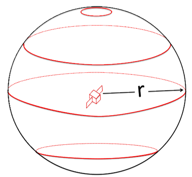
One satellite
Each satellite sends out a signal that includes its own position and the time. The receiver can calculate the time it took the signal to travel and multiply that by the speed of the signal (the speed of light) to compute the distance. That distance ("r" in the figure) defines a sphere. The receiver could be at any point on that sphere. On the diagram it is more than just the black line, it is the entire outer shell of the sphere. (Remember: three dimensions.)
This is true in theory but hardly practical, as a very sharp reader pointed out, see Letters, below.
One satellite
Two satellites
With two satellites you have an intersection of two spheres and the receiver could be in any position along those intersecting spheres. Once again, it is more than just the black lines in the diagram, your position could be at any point inside the three-dimensional shape described by the black line.
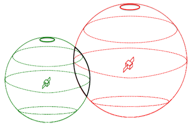
Two satellites
Three satellites
With three satellites you narrow the possible location down to one of three points (the three black points).
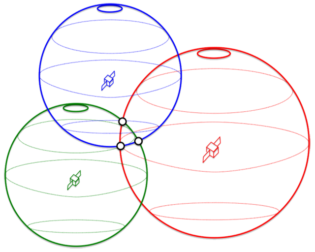
Three satellites
Four satellites
With one more satellite, you have narrowed the universe of possible intersections to just one (the single black point).
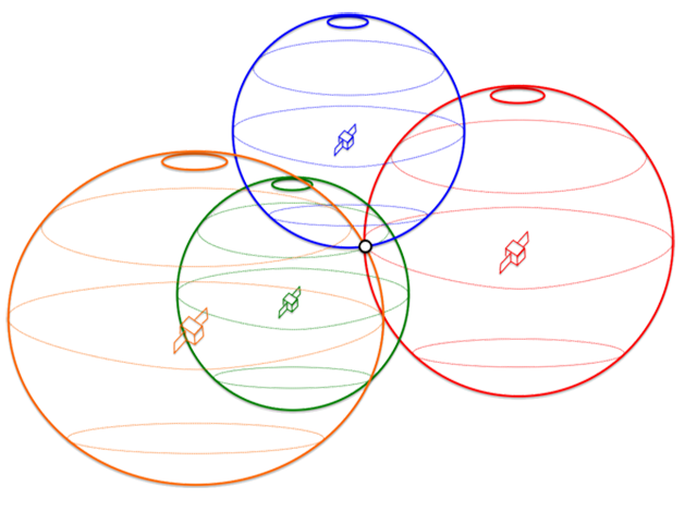
Four satellites
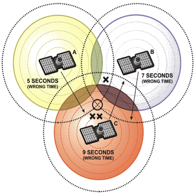
Errors, of course, are possible. . .
Position Errors
GPS Position errors, from AFAIS
Errors are possible due to:
- Minor disturbances in satellite orbits from gravitational variations from the sun and the moon or solar wind.
- Ionospheric signal delays caused by water vapor in the atmosphere; this is the biggest source of signal error.
- Slight fluctuations in the satellite atomic clocks.
- Receiver quality (faulty clocks or internal noise).
- Multi-path signal reflections off structures.
Source: AFAIS Performance-Based Navigation Presentation
Any errors from even a single satellite can throw off the estimated distance computations and therefore your estimated position. The drawing makes light of a 5 second error, but at the speed of light that would be 930,000 miles, exceeding the satellite's orbit. We must obviously be talking about very small time errors.
The performance of each satellite is measured and corrected to ensure accuracy . . .
GPS Ground Stations
There are 6 monitor stations, including the master station at Colorado Springs.
- Collect position and timing data from satellites every 12 hours.
- Send information to master control station.
- Master control station computes corrections and uploads to satellites.
Source: AFAIS Performance-Based Navigation Presentation
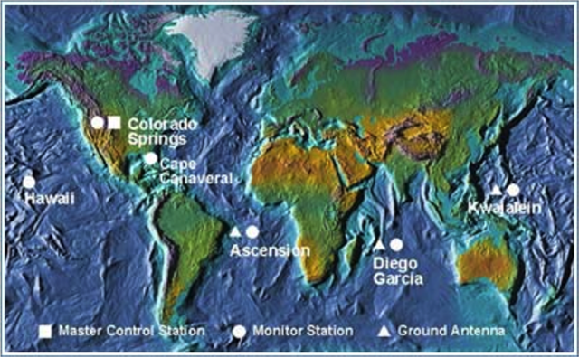
GPS Ground Stations, from AFAIS
Some receivers are capable of greater accuracy than others, but the issue isn't as extreme as some would have you believe . . .
Positioning Services
- Standard Positioning Service (SPS)
- Uses C/A code – for all users
- Single frequency (L1)
- Precise Positioning Service (PPS)
- Uses P-code – for military
- Two frequencies (L1 and L2) – more accurate
- Requires Decryption Key do use it
Source: AFAIS Performance-Based Navigation Presentation

USS Princeton launches a Harpoon missile,
from US Nav
Selective Availability
- Selective Availability was designed into the system to provide non-military or non-governmental users an intentionally limited accuracy.
- The system was turned off in 2000 and we are told the newer satellites don't even have the capability.
Source: AFAIS Performance-Based Navigation Presentation
As the world became more dependent on GPS they became more worried that one day the U.S. government would turn on selective availability and send airplanes into mountains. The U.S. government promises us that they've abandoned the concept entirely.
3
Satellite tracks
The signal coverage is supposed to be worldwide, but the satellites do not cover the world. How can that be?
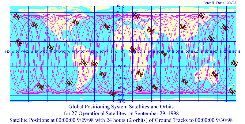
GPS Ground Tracks, from http://www.colorado.edu/geography/gcraft/notes/gps/gps_f.html
The nominal GPS Operational Constellation consists of 24 satellites that orbit the earth in 12 hours. There are often more than 24 operational satellites as new ones are launched to replace older satellites. The satellite orbits repeat almost the same ground track (as the earth turns beneath them) once each day. The orbit altitude is such that the satellites repeat the same track and configuration over any point approximately each 24 hours (4 minutes earlier each day). There are six orbital planes (with nominally four SVs in each), equally spaced (60 degrees apart), and inclined at about fifty-five degrees with respect to the equatorial plane. This constellation provides the user with between five and eight SVs visible from any point on the earth.
Source: http://www.colorado.edu/geography/gcraft/notes/gps/gps_f.html
GPS Satellite Tracks, from http://science.nasa.gov/iSat/iSAT-text-only/
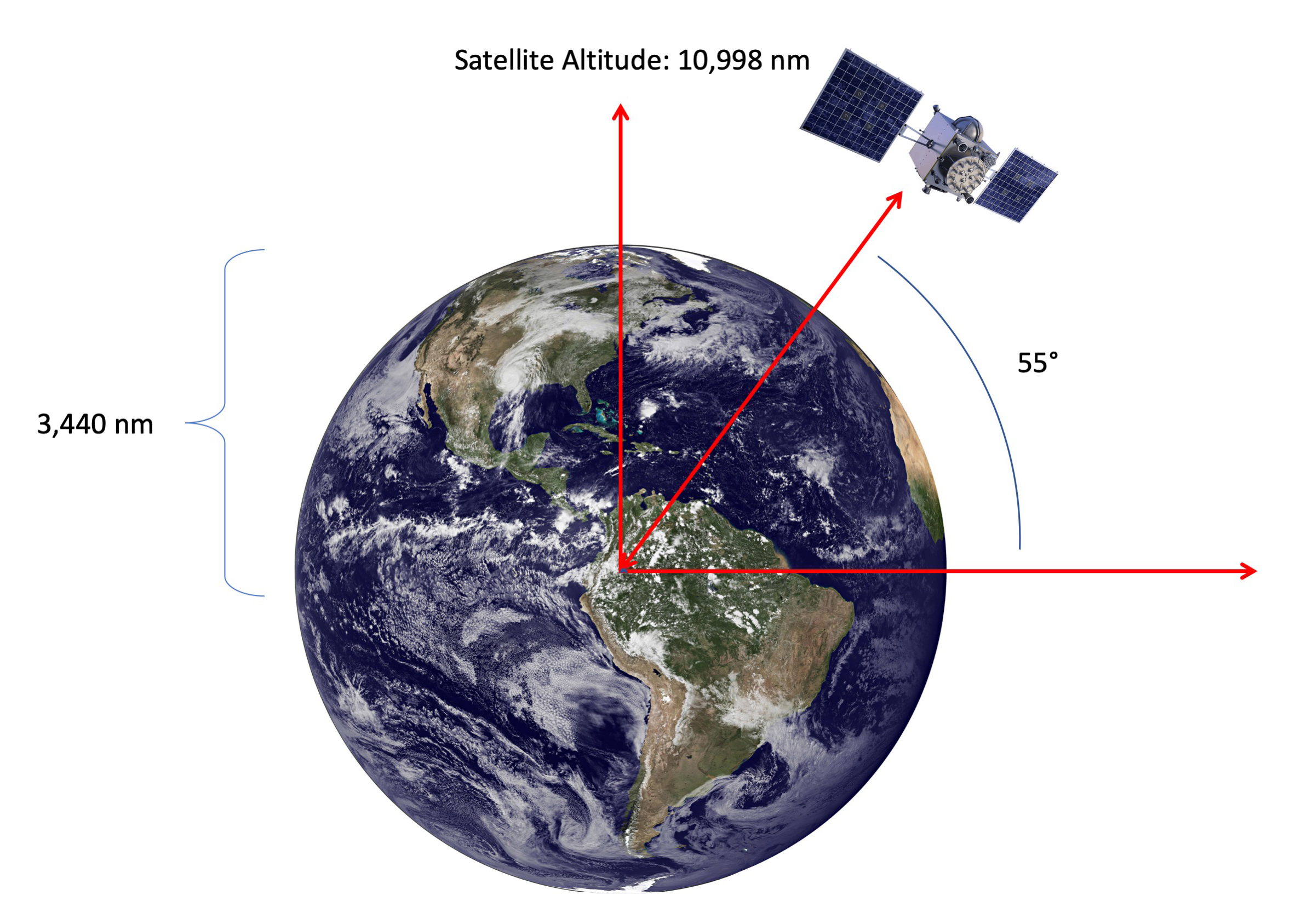
There are some who say you cannot get a GPS signal at either pole because they are inclined at 55° from the equator, they even have anecdotal evidence. NASA offers a website to track each satellite and it is true they never get higher than 55° but there are lots of reports of excellent GPS signals at each pole. What gives?
GPS Satellite Line of Sight,
Each GPS satellite traces a track over the earth from 55° North to 55° South every twelve hours. At their maximum latitudes they are actually "looking down" on the poles:
Of course you have no guarantee you will have at least one satellite that high in its orbit. In order to have line of sight on the pole, a satellite would have to be at least 18° latitude:
I've not found anything in writing that tells you there will always be at least four satellites above 18° North and 18° South, but it appears so. You should have a good GPS position at either pole.
4
GNSS versus GPS
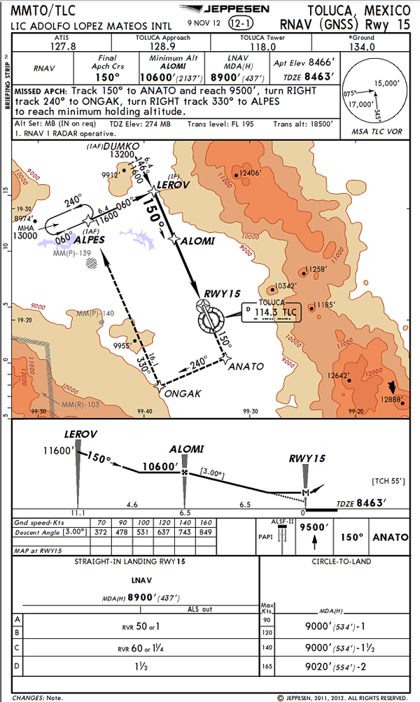
Toluca, Mexico RNAV (GNSS) Rwy 15
GNSS is used internationally to indicate any satellite-based positioning system or augmentation system. The acronym 'GNSS' includes satellite constellations, such as GPS, GLONASS, Galileo, or Beidou, along with augmentation systems such as 'SBAS' and 'GBAS'; all of which provide a satellite-based positioning service.
Source: AC 20-138D, ¶1-4.f.(2)(a)
The Global Navigation Satellite System (GNSS) includes navigation satellites and ground systems that monitor satellite signals and provide corrections and integrity messages, where needed, to support specific phases of flight. Currently, there are two navigation satellite systems in orbit: the U.S. Global Positioning Satellite (GPS) System and the Russian global navigation satellite system (GLONASS). The U.S. and Russia have offered these systems as the basis for a GNSS, free of direct user charges.
So GPS is a subset of GNSS which means all GPS approaches are GNSS but not all GNSS approaches are GPS. If the approach is marked RNAV (GNSS) you might be okay, but you have some homework to do first.
5
U.S. / ICAO Requirements to use GPS
U.S. Requirements to Use GPS
General IFR requirements
(a) General Requirements. Authorization to conduct any GPS operation under IFR requires:
(1) GPS navigation equipment used for IFR operations must be approved in accordance with the requirements specified in Technical Standard Order (TSO) TSO−C129(), TSO−C196(), TSO−C145(), or TSO−C146(), and the installation must be done in accordance with Advisory Circular AC 20−138, Airworthiness Approval of Positioning and Navigation Systems. Equipment approved in accordance with TSO−C115a does not meet the requirements of TSO−C129. Visual flight rules (VFR) and hand−held GPS systems are not authorized for IFR navigation, instrument approaches, or as a principal instrument flight reference.
(2) Aircraft using un-augmented GPS (TSO-C129() or TSO-C196()) for navigation under IFR must be equipped with an alternate approved and operational means of navigation suitable for navigating the proposed route of flight. (Examples of alternate navigation equipment include VOR or DME/DME/IRU capability). Active monitoring of alternative navigation equipment is not required when RAIM is available for integrity monitoring. Active monitoring of an alternate means of navigation is required when the GPS RAIM capability is lost.
(3) Procedures must be established for use in the event that the loss of RAIM capability is predicted to occur. In situations where RAIM is predicted to be unavailable, the flight must rely on other approved navigation equipment, re-route to where RAIM is available, delay departure, or cancel the flight.
(4) The GPS operation must be conducted in accordance with the FAA−approved aircraft flight manual (AFM) or flight manual supplement. Flight crew members must be thoroughly familiar with the particular GPS equipment installed in the aircraft, the receiver operation manual, and the AFM or flight manual supplement. Operation, receiver presentation and capabilities of GPS equipment vary. Due to these differences, operation of GPS receivers of different brands, or even models of the same brand, under IFR should not be attempted without thorough operational knowledge. Most receivers have a built−in simulator mode, which allows the pilot to become familiar with operation prior to attempting operation in the aircraft.
(5) Aircraft navigating by IFR−approved GPS are considered to be performance−based navigation (PBN) aircraft and have special equipment suffixes. File the appropriate equipment suffix in accordance with TBL 5−1−3 on the ATC flight plan. If GPS avionics become inoperative, the pilot should advise ATC and amend the equipment suffix. (6) Prior to any GPS IFR operation, the pilot must review appropriate NOTAMs and aeronautical information. (See GPS NOTAMs/Aeronautical Information).
Source: Aeronautical Information Manual ¶1-1-17.b.2.
IFR oceanic
Conduct GPS IFR operations in oceanic areas only when approved avionics systems are installed. TSO−C196() users and TSO−C129() GPS users authorized for Class A1, A2, B1, B2, C1, or C2 operations may use GPS in place of another approved means of long−range navigation, such as dual INS. (See TBL 1−1−5 and TBL 1−1−6.) Aircraft with a single installation GPS, meeting the above specifications, are authorized to operate on short oceanic routes requiring one means of long−range navigation (reference AC 20-138, Appendix 1).
Source: Aeronautical Information Manual ¶1-1-17.b.3.(a)
ICAO Requirements to Use GPS
WGS-84
Navigation data may originate from survey observations, from equipment specifications/settings or from the airspace and procedure design process. Whatever the source, the generation and the subsequent processing of the data must take account of the following: (a) all coordinate data must be referenced to the World Geodetic System — 1984 (WGS-84).
Source: ICAO Doc 9613, Attachment 2, ¶3.4 a)
Not every country uses the same system to map coordinates. While the differences are minor for en route navigation, they can be significant on approach.
See WGS-84 for more about this.
Operational Approval
Pilots shall verify, before operating on any PBN route or procedure, that they have approval to operate on the navigation specification used. Where there are additional restrictions, for example, sensor use or optional functionality [. . .], the pilot shall also verify that these restrictions are complied with.
Source: ICAO Doc 8168 Vol 1 ¶1.7.6.1
Navigation Database
Departure procedure information is contained in a navigation database using the WGS-84 coordinate system. If the navigation database does not contain the departure procedure, the procedure shall not be used.
Source: ICAO Doc 8168 Vol 1 ¶1.7.5
Arrival waypoint information is contained in a navigation database using the WGS-84 coordinate system. If the navigation database does not contain the arrival procedure, the procedure shall not be used.
Source: ICAO Doc 8168 Vol 1 ¶1.4.3.2
6
Receiver Autonomous Integrity Monitoring (RAIM)
GPS CDI and RAIM Scaling, from AFAIS Performance-Based Navigation Presentation.
For a GPS receiver to be certified for IFR navigation, it must have RAIM or an equivalent function. RAIM is simply a computer algorithm that evaluates the integrity of the GPS signal. That means it judges whether enough satellites are in view and in a good geometry to compute a sufficiently accurate position. RAIM checked now evaluates the current satellites in view. Predictive RAIM is based solely on the Almanac. In other words, RAIM uses the Almanac data to estimate where satellites are supposed to be for the future time entered. Sometimes, the number and position of satellites may result in an accuracy good enough only for certain phases of flight, ie, en route, terminal, or approach.
- RAIM — requires 5 satellites in view (1 extra) to provide the extra geometry needed to check the integrity of each satellite being used.
- Predictive RAIM — Uses almanac data or NOTAMS to determine in advance if any satellites should be excluded.
- Fault Detection and Exclusion (FDE) — With an additional satellite, an FDE system can not only detect but can automatically exclude a failed satellite. FDE is required for oceanic or remote operations.
- Baro-Aiding — Some systems can take an altimeter input to replace 1 satellite, so that RAIM only requires 4 satellites (versus 5) and FDE only requires 5 satellites (versus 6).
Source: AFAIS Performance-Based Navigation Presentation
3. RAIM is the capability of a GPS receiver to perform integrity monitoring on itself by ensuring available satellite signals meet the integrity requirements for a given phase of flight. Without RAIM, the pilot has no assurance of the GPS position integrity. RAIM provides immediate feedback to the pilot. This fault detection is critical for performance-based navigation (PBN) [. . .] because delays of up to two hours can occur before an erroneous satellite transmission is detected and corrected by the satellite control segment.
(b) There are generally two types of RAIM fault messages. The first type of message indicates that there are not enough satellites available to provide RAIM integrity monitoring. The GPS navigation solution may be acceptable, but the integrity of the solution cannot be determined. The second type indicates that the RAIM integrity monitor has detected a potential error and that there is an inconsistency in the navigation solution for the given phase of flight. Without RAIM capability, the pilot has no assurance of the accuracy of the GPS position.
Source: Aeronautical Information Manual ¶1-1-17.a.
7
Fault Detection and Exclusion (FDE) and NOTAMS
Fault Detection and Exclusion (FDE)
(a) In order for RAIM to determine if a satellite is providing corrupted information, at least one satellite, in addition to those required for navigation, must be in view for the receiver to perform the RAIM function. RAIM requires a minimum of 5 satellites, or 4 satellites and barometric altimeter input (baro−aiding), to detect an integrity anomaly. Baro−aiding is a method of augmenting the GPS integrity solution by using a non-satellite input source in lieu of the fifth satellite. Some GPS receivers also have a RAIM capability, called fault detection and exclusion (FDE), that excludes a failed satellite from the position solution; GPS receivers capable of FDE require 6 satellites or 5 satellites with baro−aiding. This allows the GPS receiver to isolate the corrupt satellite signal, remove it from the position solution, and still provide an integrity-assured position. To ensure that baro−aiding is available, enter the current altimeter setting into the receiver as described in the operating manual. Do not use the GPS derived altitude due to the large GPS vertical errors that will make the integrity monitoring function invalid.
Source: Aeronautical Information Manual ¶1-1-17.a.3.
Availability / NOTAMS
The status of GPS satellites is broadcast as part of the data message transmitted by the GPS satellites. GPS status information is also available by means of the U.S. Coast Guard navigation information service: (703) 313−5907, Internet: http://www.navcen.uscg.gov/. Additionally, satellite status is available through the Notice to Airmen (NOTAM) system.
Source: Aeronautical Information Manual, §1-1-17, ¶a.2.(a)
8
Wide Area Augmentation System (WAAS)
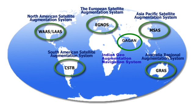
SBASs, from AFAIS Performance-Based Navigation Presentation
The acronyms 'SBAS' and 'GBAS' are the respective international designations for satellite-based and ground-based augmentation systems complying with the International Civil Aviation Organization (ICAO) standards and recommended practices (SARPs). Several countries have implemented their own versions of 'SBAS' and 'GBAS' that have specific names and acronyms. For example, WAAS is the U.S. implementation of an 'SBAS' while EGNOS is the European implementation.
Source: AC 20-138D, ¶1-4.f.(2)(b)
Wide Area Augmentation System (WAAS)
The U.S. implementation of SBAS is WAAS. The U.S. system is compatible with the European (EGNOS) and Asia Pacific (MSAS) systems.
WAAS improves the accuracy, integrity, availability and continuity of GPS signals. Additionally, the WAAS geostationary satellites provide ranging sources to supplement the GPS signals. If there are no airworthiness limitations on other installed navigation equipment, WAAS avionics enable aircraft navigation during all phases of flight from takeoff through vertically guided approaches and guided missed approaches. WAAS avionics with an appropriate airworthiness approval can enable aircraft to fly to the LPV, LP, LNAV/VNAV and LNAV lines of minima on RNAV (GPS) approaches. One of the major improvements WAAS provides is the ability to generate glide path guidance independent of ground equipment. Temperature and pressure extremes do not affect WAAS vertical guidance unlike when baro-VNAV is used to fly to LNAV/VNAV line of minima. However, like most other navigation services, the WAAS network has service volume limits, and some airports on the fringe of WAAS coverage may experience reduced availability of WAAS vertical guidance. When a pilot selects an approach procedure, WAAS avionics display the best level of service supported by the combination of the WAAS signal-in-space, the aircraft avionics, and the selected RNAV (GPS) instrument approach.
Source: AC 90-107 ¶6.b.
See: Localizer Performance with Vertical Guidance (LPV) Approach for more.
- WAAS is GPS - Augmented GPS
- WAAS Ground Stations
- 35 Stations, including 4 in Alaska, 5 in Mexico, 4 in Canada
- Monitor GPS satellites and send data to WAAS Master Station
- WAAS Master Station
- Computes GPS corrections.
- Uplinks corrections to WAAS geostationary satellites (GEOs)
- WAAS Geostationary Satellites (GEO)
- 2 satellites to cover North America
- Broadcast corrections on a standard GPS frequency — L1 (1575 MHz) This correction code qualifies as another satellite.
- Accuracy
- Lateral Accuracy - better than GPS — More like Localizer
- Vertical Accuracy – much better than GPS — Good enough for Vertical Guidance (glideslope)
- LPV minima — "Localizer Performance with Vertical Guidance"
- Performance Monitoring
- WAAS has built in FDE
- No longer need to check RAIM
- WAAS avionics provide performance levels to pilots
| GPS 95% Standard | GPS Actual Performance | |
| Horizontal | 36m | 2.74m |
| Vertical | 77m | 3.89m |
| WAAS 95% Standard | WAAS Actual Performance | |
| Horizontal | 16m | 1.08m |
| Vertical | 4m | 1.26m |
Source: AFAIS Performance-Based Navigation Presentation
9

Code 7700,
I'm a big fan of your site. It's very thoughtful, which I enjoy. I was reading your article on GPS/GNSS, and I think your explanation of the geometry is slightly off base--though I could be wrong.
You describe the possible location of the receiver when in communication with a single satellite as being a sphere--the locus of points that is a fixed distance from a point. The problem is that we don't know what time it is. We know the time at which the satellite transmitted (sent time), but the receiver doesn't know what time it is when it gets the signal (receipt time). Could be a second, could be a year. So I think with only one satellite, you could really be anywhere in the universe.
With two satellites whose clocks are synchronized, the receiver knows how much closer it is to one satellite than the other based on the difference between the receipt time and the sent time from each. That locus of points is a hyperbolid.
Additional satellites allow the calculation of additional hyperbolid spaces, on the intersection of which the receiver must lie.
Thoughts?
Best,
Geoff
Geoff,
Thank you for the kind words.
I think you are right. The theory depends on the receiver having an atomic clock synchronized exactly with the satellite, hardly possible. It is just my way of demonstrating why you need more than one satellite. It sounds like your math is stronger than mine. Can I add your email to the page? I could just make the changes but I think adding your email illustrates the complexity of it all.
James
(Geoff kindly agreed.)
References
(Source material)
Advisory Circular 20-138D, Positioning and Navigation Systems, Change 2, 4/7/16, U.S. Department of Transportation
Aeronautical Information Manual
FAA-H-8083-15, Instrument Flying Handbook, U.S. Department of Transportation, Flight Standards Service, 2001
FAA Order 8900.1
Gulfstream G450 Aircraft Operating Manual, Revision 35, April 30, 2013.
ICAO Doc 8168 - Aircraft Operations - Vol I - Flight Procedures, Appendix to Chapter 3, Procedures for Air Navigation Services, International Civil Aviation Organization, Appendix, 23/11/06
ICAO Doc 8168 - Aircraft Operations - Vol I - Flight Procedures, Procedures for Air Navigation Services, International Civil Aviation Organization, 2006
ICAO Doc 9613 - Performance Based Navigation (PBN) Manual, International Civil Aviation Organization, 2008
U.S. Air Force Advanced Instrument School (AFAIS) Performance-Based Navigation Presentation, Oct 2009
Please note: Gulfstream Aerospace Corporation has no affiliation or connection whatsoever with this website, and Gulfstream does not review, endorse, or approve any of the content included on the site. As a result, Gulfstream is not responsible or liable for your use of any materials or information obtained from this site.