For those pilots who want to avoid all things tech, or understanding all things tech, here is what you need to know about WGS-84 in a nutshell.
— James Albright

Updated:
2025-06-01
- The United States Department of Defense first developed GPS for military uses and that eventually morphed into a worldwide civil system of navigation.
- Various entities around the world started cataloging the positions of things on earth as a way of finding them and, of course, avoiding them. The standard most of us use is known as the World Geodetic System of 1984, or WGS-84.
- If your aircraft and its database uses WGS-84 — and most do — then it is critically important that your navigation and approach charts are based on WGS-84 too.
- Part of your mission planning to international destinations needs to ask this question for every procedure you fly: is this WGS-84 compliant? If not, your manufacturer should have procedures to mitigate the risk.

1
History
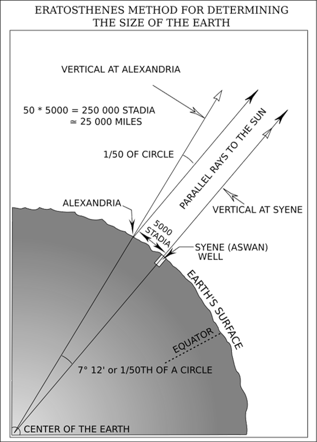
Erastothenes' Size of the Earth, from
Geodesy for the Layman, Figure 1.
Considering the Earth
Contrary to popular folklore, it has long been obvious that the earth is a sphere of some sort, and as early as 240 BC the chief librarian at the Great Library of Alexandria, Egypt, had come up with an idea just how big the sphere is. . .
In Egypt, a Greek scholar and philosopher, Eratosthenes, set out to make more explicit measurements. He had observed that on the day of the summer solstice, the midday sun shone to the bottom of a well in the town of Syene (Aswan). Figure 1. At the same time, he observed the sun was not directly overhead at Alexandria; instead, it cast a shadow with the vertical equal to 1/50th of a circle (7° 12'). To these observations, Eratosthenes applied certain "known" facts (1) that on the day of the summer solstice, the midday sun was directly over the line of the summer Tropic Zone (Tropic of Cancer)-Syene was therefore concluded to be on this line; (2) the linear distance between Alexandria and Syene was 500 miles; (3) Alexandria and Syene lay on a direct north south line. From these observations and "known" facts, Eratosthenes concluded that, since the angular deviation of the sun from the vertical at Alexandria was also the angle of the subtended arc, the linear distance between Alexandria and Syene was 1/50 of the circumference of the earth or 50 x 500 = 25,000 miles. A currently accepted value for the earth’s circumference at the Equator is 24,901 miles, based upon the equatorial radius of the World Geodetic System.
Source: Geodesy for the Layman, Ch. 1
Sphere "Flattening"
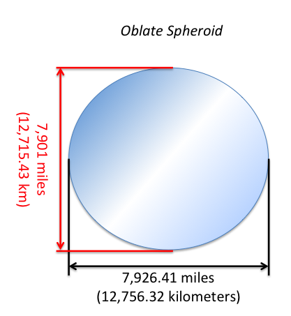
Oblate spheroid
The earth is basically round because gravity pulls with equal strength in all directions, tending to smooth variations towards a norm. But it isn't perfectly round, the centrifugal effects of its rotation tends to make it wider in the middle than it is tall. Technically, you would call the basic shape an oblate spheroid.
Sphere versus Geoid
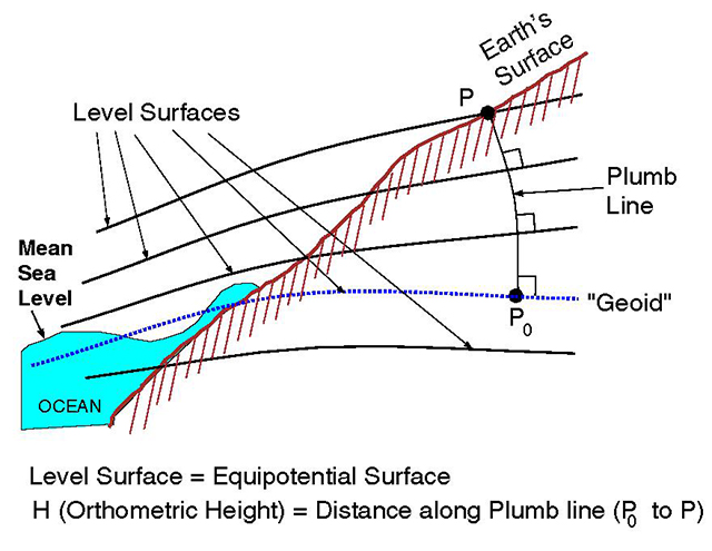
Schematic diagram, from National Geodetic Survey
It is helpful to think of the earth's shape as a "geoid," the shape it would most closely resemble figuring the effects of gravity.
There have been many definitions of the "geoid" over 150 years or so. Here is the one currently adopted at NGS:
- geoid: The equipotential surface of the Earth's gravity field which best fits, in a least squares sense, global mean sea level
Even though we adopt a definition, that does not mean we are perfect in the realization of that definition. For example, altimetry is often used to define "mean sea level" in the oceans, but altimetry is not global (missing the near polar regions). As such, the fit between "global" mean sea level and the geoid is not entirely confirmable.
Source: National Geodetic Survey
The earth doesn't conform to the geoid because the magnetic field isn't uniform and the earth's surface is filled with varying heights of land as well as a sea that does not maintain the same level throughout.
Mapping the Earth
- The Department of Defense, in the late 1950’s began to develop the needed world system to which geodetic datums could be referred and compatibility established between the coordinates of widely separated sites of interest. Efforts of the Army, Navy and Air Force were combined leading to the DoD World Geodetic System 1960 (WGS 60).
- In January 1966, a World Geodetic System Committee composed of representatives from the Army, Navy and Air Force, was charged with the responsibility of developing an improved WGS needed to satisfy mapping, charting and geodetic requirements. Additional surface gravity observations, results from the extension of triangulation and trilateration networks, and large amounts of Doppler and optical satellite data had become available since the development of WGS 60. Using the additional data and improved techniques, WGS 66 was produced which served DoD needs for about five years after its implementation in 1967.
- After an extensive effort extending over a period of approximately three years, the Department of Defense World Geodetic System 1972 was completed. Selected satellite, surface gravity and astrogeodetic data available through 1972 from both DoD and non-DoD sources were used in a Unified WGS Solution (a large scale least squares adjustment).
Source: Geodesy for the Layman, Ch. 8
Adopting a Standard
- The World Geodetic System was developed by the U.S. Department of Defense in 1966 as a process for accurately surveying the earth and providing methods for assigning latitude/longitude/altitude coordinates for the purposes of navigation. With the deployment of the GPS constellation, the surveying process was updated in 1984 to incorporate GPS as the primary method of reference. Therefore, the ‘84’ is appended to the name to identify the year that the system was last updated.
- Throughout history, there have been numerous methods to survey the surface of the earth, but the WGS-84 system is the most accurate, having an overall fidelity of less than 1 meter. As an example, the WGS-84 system placed the actual Prime Meridian (0o line of longitude) approximately 100 meters east of where it traditionally lies in Greenwich, UK. This is a prime example of how different methodologies can yield different results.
- In 1989, ICAO officially adopted WGS-84 as the standard geodetic reference system for future navigation with respect to international civil aviation. With this policy, virtually all countries use the WGS-84 standard to publish waypoint coordinates for navigation (e.g., airports, runways, navaids, etc.). This data is compiled and disseminated throughout the world in formats such as navigation charts and is the data contained in most FMS Navigation Databases.
Source: Honeywell Direct-To, pg. 11
2
The technical stuff
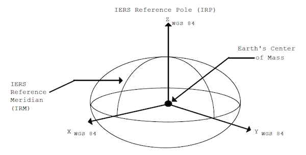
WGS84 Coordinate System Definition, from NIMA, Figure 2.1
Definition
The WGS 84 Coordinate System is a Conventional Terrestrial Reference System (CTRS). The definition of this coordinate system follows the criteria outlined in the International Earth Rotation Service (IERS) Technical Note 21 [1]. These criteria are repeated below:
- It is geocentric, the center of mass being defined for the whole Earth including oceans and atmosphere
- Its scale is that of the local Earth frame, in the meaning of a relativistic theory of gravitation
- Its orientation was initially given by the Bureau International de l’Heure (BIH) orientation of 1984.0
- Its time evolution in orientation will create no residual global rotation with regards to the crust
The WGS 84 Coordinate System is a right-handed, Earth-fixed orthogonal coordinate system and is graphically depicted in [the figure].
- Origin = Earth’s center of mass
- Z-Axis = The direction of the IERS Reference Pole (IRP). This direction corresponds to the direction of the BIH Conventional Terrestrial Pole (CTP) (epoch 1984.0) with an uncertainty of 0.005
- X-Axis = Intersection of the IERS Reference Meridian (IRM) and the plane passing through the origin and normal to the Z-axis. The IRM is coincident with the BIH Zero Meridian (epoch 1984.0) with an uncertainty of 0.005
- Y-Axis = Completes a right-handed, Earth-Centered Earth-Fixed (ECEF) orthogonal coordinate system
The WGS 84 Coordinate System origin also serves as the geometric center of the WGS 84 Ellipsoid and the Z-axis serves as the rotational axis of this ellipsoid of revolution.
Source: NIMA, ¶2.1
The World Geodetic System 84 is a standard used by most of the world to define exactly where a set of coordinates are on the earth. The issues on using one standard versus another are more than just determining where something is left, right, forward, and aft. Another issue is that the world isn't a perfect sphere, or geoid, and defining where something is can also vary in height above the center of the earth.
3
ICAO Requirement
Navigation data may originate from survey observations, from equipment specifications/settings or from the airspace and procedure design process. Whatever the source, the generation and the subsequent processing of the data must take account of the following:
- all coordinate data must be referenced to the World Geodetic System — 1984 (WGS-84);
- all surveys must be based upon the International Terrestrial Reference Frame;
- all data must be traceable to their source;
- equipment used for surveys must be adequately calibrated;
- software tools used for surveys, procedure design or airspace design must be suitably qualified;
- standard criteria and algorithms must be used in all designs;
- surveyors and designers must be properly trained;
- comprehensive verification and validation routines must be used by all data originators;
- procedures must be subjected to ground validation and, where necessary, flight validation and flight inspection prior to publication. For guidance on the validation process see Doc 9906, Volume 5 — Validation of Instrument Flight Procedures;
- aeronautical navigation data must be published in a standard format, with an appropriate level of detail and to the required resolution; and
- all data originators and data processors must implement a quality management process which includes:
i) a requirement to maintain quality records;
ii) a procedure for managing feedback and error reporting from users and other processors in the data chain.
Source: ICAO Doc 9613 ¶3.4
4
Refinements
Getting better
Before WGS-84 there were three other versions: WGS-60, WGS-66, and WGS-72. Of those, only WGS-72 was considered suitable for navigation. WGS-84 was considered revolutionary because it was the first system truly based on satellite geodetic systems, used the earth's center of mass (as opposed to an arbitrary reference point, and was designed for the then-new Global Positioning System.
Despite the WGS-84 name, the system has not been static since 1984. Just a few examples:
In 1994, the system had what they called the "First Realization" which started treating WGS-84 as a dynamic, living system, accounting for tectonic motion, station drift, and improved satellite tracking.
In 2001, the U.S. government turned off "Selective Availability" (SA), which degraded accuracy for civilian use. With SA, GPS had typical accuracy of about 100 meters. With SA, civilians got accuracy of 10 to 15 meters.
You might be wondering about that 10 to 15 meters accuracy when some smartphones can get you within 1 meter and your aircraft's WAAS enabled receiver can be within 1 to 3 meters. Most of this accuracy improvement is due to the use of multiple satellites, better sensors, and correction methods for atmospheric delays, satellite orbit errors, and other issues.
Quantum Global Positioning System: the future?
If you thought going from Inertial Navigation Systems (INS) to Global Positioning Satellite (GPS) systems was a Quantum leap, you are right. Right, that is, if you define Quantum as most people do:
Quantum (everyday usage definition): something revolutionary.
Wrong, however, if you define the word as it comes from the study of physics:
Quantum Mechanics: the branch of physics that describes the behavior of matter and energy at the smallest scales, like atoms, electrons, photons, and other subatomic particles.
A quantum navigation system uses atoms like rubidium or cesium that are cooled to near absolute zero using lasers. Lasers? Yes, shooting a laser beam through these atoms causes the atom to give off energy as the beam exits, and as they lose energy they cool. Why do they need to be cool? The colder the atoms becomes the slower it moves, making measurement easier.
The atoms are then held in "superposition" using magnetic traps. These traps use magnetic fields to essentially suspend the atoms where you want them.
You then shoot the atoms with light pulses from lasers that causes one part of the atom to move up and the other to move down. This is called atom interferometry and is used to measure for acceleration, rotation, and gravitational changes. These measurements are extremely precise and are not subject to the drift found in conventional inertial navigation systems.
For a primer on quantum navigation, see this YouTube video from Dr. Ben Miles: The Genius Behind the Quantum Navigation Breakthough.
Does this discussion make your brain hurt? Maybe a diversion from YouTube is in order: My Brain Hurts.
For quantum navigation systems from a pilots perspective: This Technology Could Revolutionize Airline Safety! (Mentour Now). Skip to the 11:50 minute mark.
I know all this seems like science fiction, but I think we could be seeing this in airplanes before the 2020s are over. I think we as an industry have become too reliant on GPS and the change can't happen fast enough!
References
(Source material)
Geodesy for the Layman, Defense Mapping Agency, Building 56 U.S. Naval Observatory DMA TR 80-003, Washington DC 20305, 16 March 1984
ICAO Doc 9613 - Performance Based Navigation (PBN) Manual, International Civil Aviation Organization, Fourth Edition, 2013
http://www.ngs.noaa.gov/GEOID/geoid_def.htm, National Geodetic Survey
World Geodetic System 1984, Department of Defense, National Imagery and Mapping Agency (NIMA), NSN 7643-01-402-0347, NIMA TR8350.2, Third Edition, Amendment 1, 3 January 2000