Having grown up in high performance jets that tend to fly above most of this stuff I don't have a lot of experience dealing with icing that the airplane cannot handle. (My worst experience: No Time to Nap.)
— James Albright

Updated:
2020-12-05
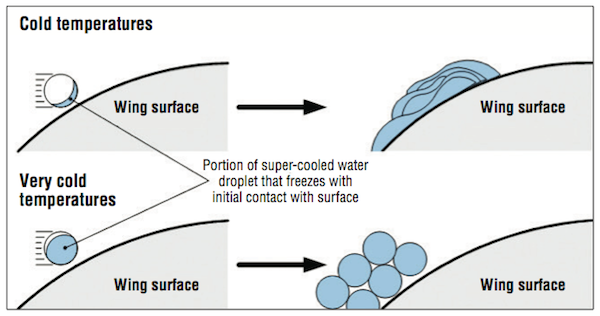
Ice accretion vs. temperature, from ProPilot.
So let me just relate a few facts and leave it at that. For me, dealing with icing has always amounted to avoid it if you can, follow aircraft manufacturer limits and procedures when you can't.
3 — Icing intensities, contractions, and airframe ice accumulation

1
Icing types
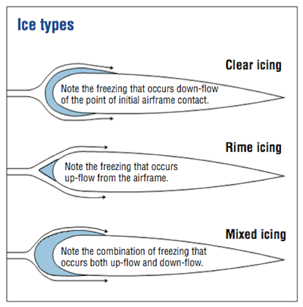
Ice types, from ProPilot
- When a supercooled liquid droplet strikes an object that is at a subfreezing temperature, that object serves as the ice nucleus, and any supercooled liquid coming into contact with it will freeze quickly. The colder the object or the smaller the droplet, the more quickly the ice will form. These near-instant freezing droplets usually create rime ice. Because it freezes instantly, rime ice tends to trap air within its structure, which gives it a milky appearance, and often makes it more pliable than other forms of ice.
- Clear ice commonly forms at temperatures between 2° C (35° F) and -10° C (14° F), and often poses a greater danger than rime ice. The reasons are that clear ice is more difficult to see, it can appear as a "wet" surface and it changes the shape of the airfoil. And because it takes time to freeze, it can extend to surfaces that are not protected by anti-ice or deice systems. While rime can form at warmer temperatures, it is most likely in temperatures below -15° C (5° F), and it tends to be limited to the leading edges of airfoils and around protruding surfaces.
- In the intervening temperature range of -10° C (14° F) to -15° C (5° F), pilots are more likely to experience mixed icing – a combination of rime and clear ice. Mixed ice can form quickly, and become very thick and rough.
Source: ProPilot
| Clear Ice | See Glaze Ice. |
| Glaze Ice | Ice, sometimes clear and smooth, but usually containing some air pockets, which results in a lumpy translucent appearance. Glaze ice results from supercooled drops/droplets striking a surface but not freezing rapidly on contact. Glaze ice is denser, harder, and sometimes more transparent than rime ice. Factors, which favor glaze formation, are those that favor slow dissipation of the heat of fusion (i.e., slight supercooling and rapid accretion). With larger accretions, the ice shape typically includes "horns" protruding from unprotected leading edge surfaces. It is the ice shape, rather than the clarity or color of the ice, which is most likely to be accurately assessed from the cockpit. The terms "clear" and "glaze" have been used for essentially the same type of ice accretion, although some reserve "clear" for thinner accretions which lack horns and conform to the airfoil. |
| Intercycle Ice | Ice which accumulates on a protected surface between actuation cycles of a deicing system. |
| Known or Observed or Detected Ice Accretion | Actual ice observed visually to be on the aircraft by the flight crew or identified by onboard sensors. |
| Mixed Ice | Simultaneous appearance or a combination of rime and glaze ice characteristics. Since the clarity, color, and shape of the ice will be a mixture of rime and glaze characteristics, accurate identification of mixed ice from the cockpit may be difficult. |
| Residual Ice | Ice which remains on a protected surface immediately after the actuation of a deicing system. |
| Rime Ice | A rough, milky, opaque ice formed by the rapid freezing of supercooled drops/droplets after they strike the aircraft. The rapid freezing results in air being trapped, giving the ice its opaque appearance and making it porous and brittle. Rime ice typically accretes along the stagnation line of an airfoil and is more regular in shape and conformal to the airfoil than glaze ice. It is the ice shape, rather than the clarity or color of the ice, which is most likely to be accurately assessed from the cockpit. |
| Runback Ice | Ice which forms from the freezing or refreezing of water leaving protected surfaces and running back to unprotected surfaces. |
| Note: Ice types are difficult for the pilot to discern and have uncertain effects on an airplane in flight. Ice type definitions will be included in the AIM for use in the "Remarks" section of the PIREP and for use in forecasting. | |
Source: Aeronautical Information Manual, Tble 7-1-8
2
Icing conditions
- Nearly all aircraft icing occurs in supercooled clouds. Liquid droplets are present at outside air temperatures below 0°C (32°F) in these clouds. At outside air temperatures close to 0°C (32°F), the cloud may consist entirely of such droplets, with few or no ice particles present. At decreasing temperatures, the probability increases that ice particles will be found in significant numbers along with the liquid droplets. In fact, as the ice water content increases, the liquid water content tends to decrease since the ice particles grow at the expense of the water particles. At temperatures below about -20°C (-4°F), most clouds are made up entirely of ice particles.
- The general rule is that the more ice particles and the fewer liquid droplets that are present, the less ice accumulation on the airframe. This is because the ice particles tend to bounce off an aircraft surface, while the supercooled droplets freeze and adhere. As a result, ice accumulation is often greatest at temperatures not too far below 0 °C (32°F), where liquid water content can be abundant, and is usually negligible at temperatures below about -20°C (-4°F).
- An exception to the general rule just stated may be made for surfaces heated by a thermal ice protection system (or by aerodynamic heating near the stagnation point of an aircraft component at speeds in excess of perhaps 250 knots). For such surfaces, ice particles may melt upon impact and then run back to colder aft regions and refreeze.
- The higher liquid water content associated with temperatures near freezing is not the only concern. Tests have shown that at outside air temperatures near freezing, the total air temperature may be above freezing. The result is no ice accretion near the stagnation, but the refreezing of the water running back on the airfoil, causing runback ice accretions, possibly behind the protected areas. The formation of a ridge is possible. Pilots should be vigilant at total temperatures (TAT) between -5°C (23°F) and +2°C (35°F). Pilots should know whether the temperature instrument they are reading in the cockpit is outside air temperature (OAT) or TAT.
- The greater the liquid water content of the cloud, the more rapidly ice accumulates on aircraft surfaces. The size of the droplets also is important. Larger droplets have greater inertia and are less influenced by the airflow around the aircraft than smaller droplets. The result is that larger droplets will impinge on more of the aircraft surface than smaller droplets.
Source: AC 91-74A, ¶3-1.
| Appendix C Icing Conditions | Appendix C (14 CFR, Part 25 and 29) is the certification icing condition standard for approving ice protection provisions on aircraft. The conditions are specified in terms of altitude, temperature, liquid water content (LWC), representative droplet size (mean effective drop diameter [MED]), and cloud horizontal extent. |
| Forecast Icing Conditions | Environmental conditions expected by a National Weather Service or an FAA-approved weather provider to be conducive to the formation of inflight icing on aircraft. |
| Freezing Drizzle (FZDZ) | Drizzle is precipitation at ground level or aloft in the form of liquid water drops which have diameters less than 0.5 mm and greater than 0.05 mm. Freezing drizzle is drizzle that exists at air temperatures less than 0_C (supercooled), remains in liquid form, and freezes upon contact with objects on the surface or airborne. |
| Freezing Precipitation | Freezing precipitation is freezing rain or freezing drizzle falling through or outside of visible cloud. |
| Freezing Rain (FZRA) | Rain is precipitation at ground level or aloft in the form of liquid water drops which have diameters greater than 0.5 mm. Freezing rain is rain that exists at air temperatures less than 0_C (supercooled), remains in liquid form, and freezes upon contact with objects on the ground or in the air. |
| Icing in Cloud | Icing occurring within visible cloud. Cloud droplets (diameter < 0.05 mm) will be present; freezing drizzle and/or freezing rain may or may not be present. |
| Icing in Precipitation | Icing occurring from an encounter with freezing precipitation, that is, supercooled drops with diameters exceeding 0.05 mm, within or outside of visible cloud. |
| Known Icing Conditions | Atmospheric conditions in which the formation of ice is observed or detected in flight. Note: Because of the variability in space and time of atmospheric conditions, the existence of a report of observed icing does not assure the presence or intensity of icing conditions at a later time, nor can a report of no icing assure the absence of icing conditions at a later time. |
| Potential Icing Conditions | Atmospheric icing conditions that are typically defined by airframe manufacturers relative to temperature and visible moisture that may result in aircraft ice accretion on the ground or in flight. The potential icing conditions are typically defined in the Airplane Flight Manual or in the Airplane Operation Manual. |
| Supercooled Drizzle Drops (SCDD) | Synonymous with freezing drizzle aloft. |
| Supercooled Drops or /Droplets | Water drops/droplets which remain unfrozen at temperatures below 0_C. Supercooled drops are found in clouds, freezing drizzle, and freezing rain in the atmosphere. These drops may impinge and freeze after contact on aircraft surfaces. |
| Supercooled Large Drops (SLD) | Liquid droplets with diameters greater than 0.05 mm at temperatures less than 0_C, i.e., freezing rain or freezing drizzle. |
Source: Aeronautical Information Manual, Tble 7-1-9
3
Icing intensities, contractions, and airframe ice accumulation
| Intensity | Contraction | Airframe Ice Accumulation |
| Trace | TRACE | Ice becomes perceptible. Rate of accumulation slightly greater than rate of sublimation. It is not hazardous even without the use of deicing/anti-icing equipment unless encountered for an extended period of time (over 1 hour). |
| Light | LGT | The rate of accumulation may create a problem if flight is prolonged in this environment (over 1 hour). Occasional use of deicing/anti-icing equipment removes/prevents accumulation. It does not present a problem if the deicing/anti-icing equipment is used. |
| Moderate | MOD | The rate of accumulation is such that even short encounters become potentially hazardous and use of deicing/anti-icing equipment or diversion is necessary. |
| Severe | SEV | The rate of accumulation is such that deicing/anti-icing equipment fails to reduce or control the hazard. Immediate diversion is necessary. |
Source: AC 00-45G, Table 3-9
4
Icing in clouds
- Stratus clouds, sometimes called layer clouds, form a stratified layer that may cover a wide area. The lifting processes that form them are usually gradual, and so they rarely have exceptionally high liquid water contents. Icing layers in stratus clouds with a vertical thickness in excess of 3,000 feet are rare, so a change of altitude of a few thousand feet may take the aircraft out of icing.
- Cumulus clouds, which often form because of vigorous convection, can have high liquid water content. If an aircraft traverses them, the icing can be rapid. Because they tend to be of limited horizontal extent, it may be possible to avoid many of them. Because of the vertical development of cumulus clouds, icing conditions can be found in layers thousands of feet in depth, but with much less horizontal development than in stratus clouds. This class of clouds includes the cumulonimbus, or thunderstorm, clouds. Updrafts in such clouds can be great and result in very large liquid water contents. Thus, a large icing threat can be added to the other excellent reasons to stay out of such clouds. The thunderhead anvil can spread out from the core for several miles and is composed mainly of ice crystals. These crystals will not adhere to unheated surfaces when they hit, but they may melt on a heated surface, run back, and refreeze. The ice content in the anvils can be high, and ingestion of the ice crystals has resulted in uncommanded thrust reductions.
- Orographic clouds form when moist air is lifted by flowing up the side of a mountain. As the parcel of air is lifted, it cools and forms a cloud. Such clouds can contain a large volume of water, and in some cases, large droplets.
- Wave clouds, recognized by their "wavy" tops, can have high liquid water contents. Continued flight along a wave may result in airframe icing.
- Cirrus clouds, found at very high, cold altitudes, are composed entirely of ice particles. Flight through these clouds should not result in structural icing, although the possibility exists for runback icing from the refreezing of particles that melted on thermally or aerodynamically heated surfaces.
Source: AC 91-74A, ¶3-2.
5
Aerodynamic effects
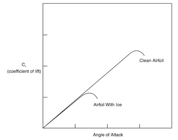
Lift curve, from AC 91-74A, figure 7.
[The figure] shows how ice often affects the coefficient of lift for an airfoil. Note that at very low angles of attack, there may be little or no effect of the ice on the coefficient of lift. Thus when cruising at a low angle of attack (AOA), ice on the wing may have little effect on the lift. However, note that the maximum coefficient of lift (CLmax) is significantly reduced by the ice, and the AOA at which it occurs (the stall angle) is much lower. Thus when slowing down and increasing the AOA for approach, therefore, the pilot may find that ice on the wing that had little effect on lift in cruise now causes stall to occur at a lower AOA and higher speed. Even a thin layer of ice at the leading edge of a wing, especially if it is rough, can have a significant effect in increasing stall speed. For large ice shapes, especially those with horns, the lift may also be reduced at a lower AOA as well. Depending on the airfoil section, the lift loss may even be larger if ice accretes behind areas normally protected, such as due to large drop impingement and runback.
Source: AC 91-74A ¶4-2.a.
The figure is grossly simplified, the shape of the curve is likely to be changed as well. But the bottom line is correct: you will have less lift.
References
(Source material)
Advisory Circular 00-45G, Aviation Weather Services, July 29, 2010, U.S. Department of Transportation
Advisory Circular 91-74A, Pilot Guide to Flight in Icing Conditions, 12/31/07, U.S. Department of Transportation
Aeronautical Information Manual
Shein, Karsten, "Icing," Professional Pilot, October 2014, pp. 90 - 97.