Convective weather is a broad topic but paring it down to stuff a pilot needs is easier said than done. I need to work on this more.
— James Albright

Updated:
2015-10-10
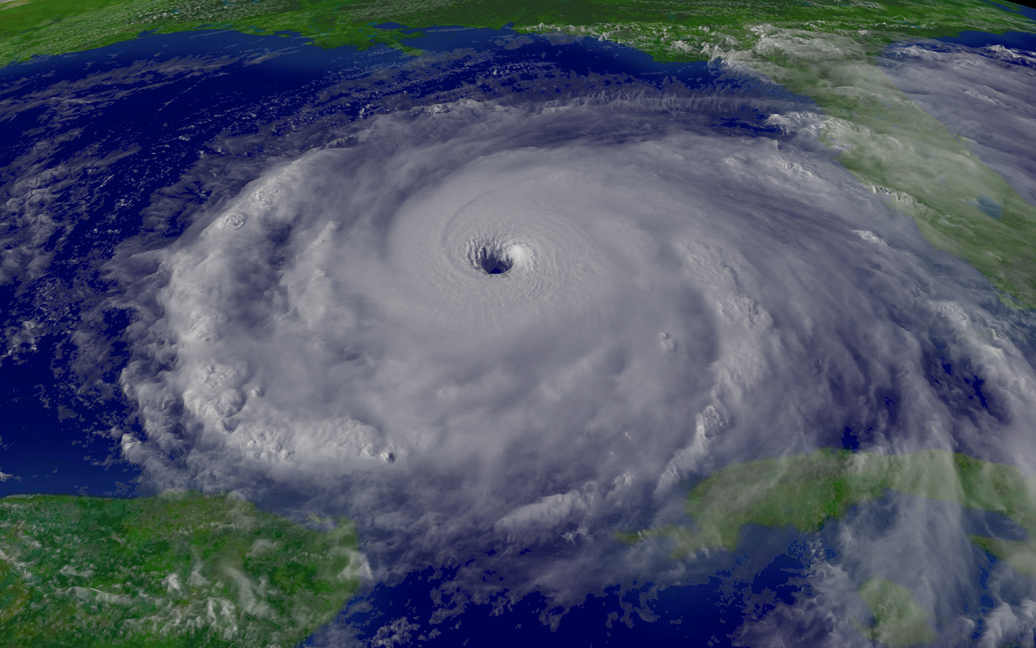
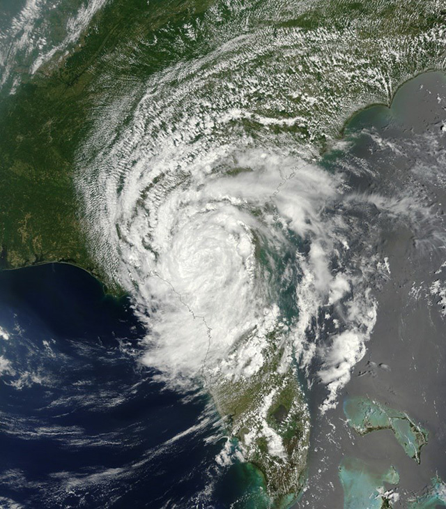
Hurricane Rita
Fortunately everyone — we pilots, air traffic control, the airlines, even the travelling public — understand better these days to give this kind of weather some distance. But it still pays to know what you are dealing with.
1 — Conditions needed for the formation of convective weather
3 — Thunderstorms
4 — Tropical weather systems
6 — Engine ice crystal ingestion

1
Conditions needed for the formation of convective weather
Overview
The convective process involves heating of the air at the surface thus lifting the air from the Earth’s surface. As the warm air rises, the water vapor condenses into water or ice. The convective process generates the following:
- Clouds
- Complete weather systems
- Thunderstorms
The vertical motion — updrafts and downdrafts — can reach 10,000 fpm.
Three meteorological conditions for the formation of convective weather
- Triggers
- Unstable Air
- Water Vapor
Trigger: Surface heating
Solar energy from the sun arriving at the surface begins to heat the surface. As the ground surface gets heated, the air near it warms up and starts to rise. Thus, the process of convection, which in turn helps cloud formation.
Following are the characteristics of the surface heating process in the context of convective weather:
- Scattered or no cloud conditions help surface heating.
- Land heats faster than water, so clouds form over land first.
- Clouds develop over the areas that are heated faster than others.
Trigger: Upslope motion

Orographic lifting
Upslope motion of air, which is also known as orographic lifting, is the process of air moving uphill as a result of the surface wind flowing towards the base of the hill.
Characteristics of Upslope Motion
- Surface wind of at least 5-10 knots is sufficient.
- Clouds form near the top or along the ridge lines.
- Upslope motion causing clouds can occur in overcast sky conditions.
- Upslope process can also result from air flowing over a gradually rising terrain.
Trigger: Cold front
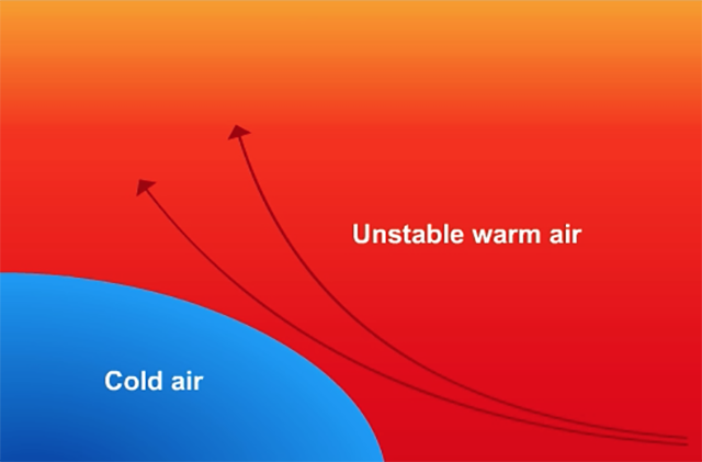
Cold front
The slope of the cold frontal boundary generates lift in the air ahead of the moving frontal boundary, thus triggering convective weather.
Following are the characteristics of cold fronts in the context of convective weather:
- A strong cold front is much better at generating lift than a weaker cold front.
- The relatively uniform frontal boundary generates uniform lift over a long distance. Cold fronts are the best generators of cumuliform clouds.
Trigger: Warm front
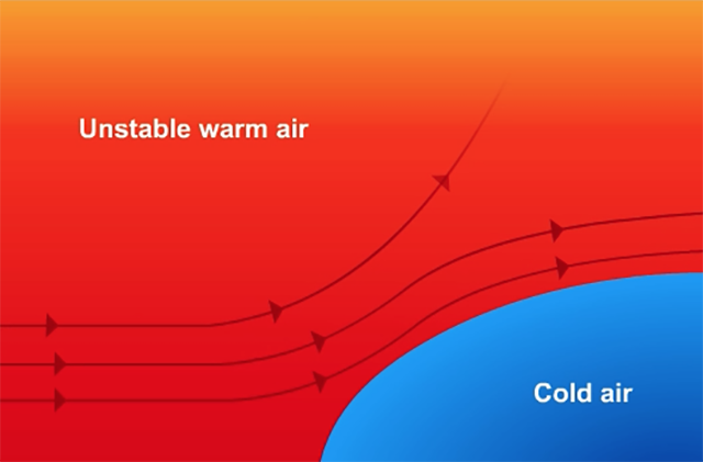
Warm front
Following are the characteristics of warm fronts in the context of convective weather:
- The warm front boundary is usually rather shallow and is not a good trigger for cumuliform clouds.
- A sufficiently steep warm front can generate lines of cumuliform clouds.
- Warm fronts are not as good a trigger for convective weather as cold fronts.
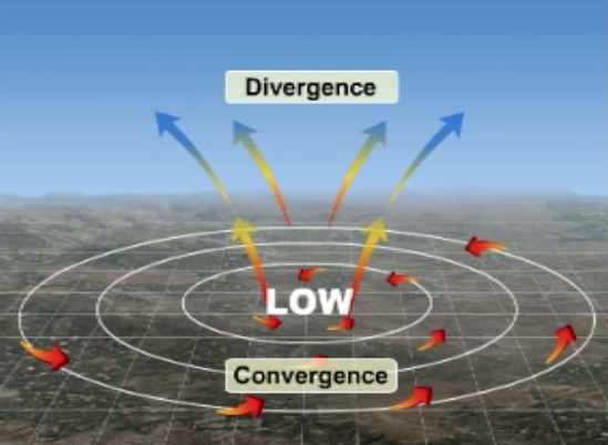
Trigger: Low-pressure system
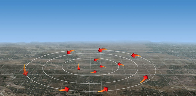
Convergence
The mechanism that low-pressure systems exhibit is the inflow of air toward the core of the pressure system. This inflow occurs at the surface of the Earth. The inflow motion is commonly called 'convergence' in weather briefings. As the air converges toward the center of the low pressure, the converging air must move upwards.
Low-pressure systems form lines and clusters of cumuliform clouds.
Condition: Unstable air
Once upward motion of air is triggered, unstable air sustains the upward motion until the air reaches the significant altitudes needed to produce cumuliform clouds.
Following is the process for unstable air to cause convective weather:
- After a trigger initiates upward motion and the air begins to rise, the pressure drops and consequently the temperature drops as well.
- The cooling rate of the rising air should be less than the cooling rate of the surrounding air.
- The rate of cooling for rising air varies inversely with the amount of water vapor present. Dry (low humidity) air cools faster than moist (humid) air.
Condition: Water Vapor
Presence of water vapor in the air causes the rate of cooling for rising air to be lower than the rate for the surrounding air thereby contributing to the instability of air which in turn satisfies a condition for convective weather.
Furthermore, to build clouds we definitely need water vapor that we can change to liquid and solid water.
2
Cumuliform clouds
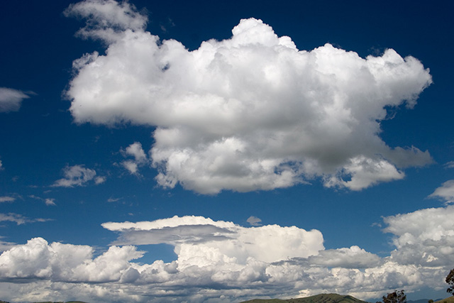
Cumuliform cloud
The characteristics of cumuliform clouds.
- They are formed by the convective process.
- They have a significant vertical extent of more than 10,000 feet.
- Their tops and sides are rough and ragged.
- Their diameter is 6 nm/11 km.
- They can exist as a single cloud, lines of clouds and as clusters of clouds.
Types of cumuliform clouds and their characteristics.
Swelling cumulus
Swelling cumulus
- It is the first stage of a developing cumuliform cloud.
- Height is about 10,000 feet.
- Its sides exhibit air motions.
- It has no international symbol assigned.
Towering cumulus
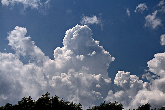
Towering cumulus
- It is the second stage of a developing cumuliform cloud.
- Its top extends beyond 18,000 feet in the middle latitudes and 24,000 feet in the tropic latitudes.
- Ice crystals form at the top.
- They retain their shape, the top does not blow off or shear off; hence, Towering Cumulus.
- It can produce rain showers, low-level windshear, strong crosswinds and heavy rains.
- Its international symbol is 'TCU'.
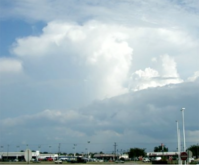
Cumulonimbus
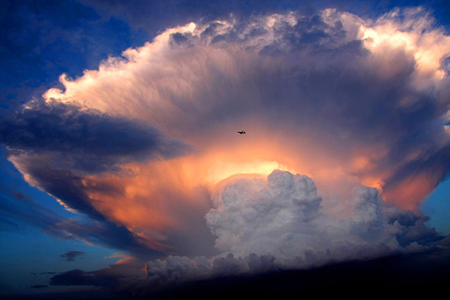
Cumulonimbus
- Another name for thunderstorm, thundershower, or thunderhead.
- It has anvil top in the middle latitudes.
- It has mushroom top in the tropical latitudes.
- It reaches the Tropopause and sometimes extends through the tropopause into the stratosphere.
- It contains hail in a range of sizes.
- It produces severe turbulence around its edges at middle and high altitudes.
- It produces Lightning, wind gusts, low-level windshear and strong crosswind components at the surface.
- Its international symbol is 'CB'.
The hazards of cumuliform clouds.
- Vertical motion ‐ the height or diameter of a cumuliform cloud does not determine the strength or intensity of its vertical motion.
- Gusty winds — with changes in direction and speed.
- Hail — the lower the freezing level the more likely the hail will reach the surface.
- Lightning — the discharge of lightning indicates the cumulonimbus is mature.
- Low-level windshear
- Heavy rain
The precautions to be taken against cumuliform clouds
- All forms of cumuliform clouds should be avoided.
- Pilots should not attempt to penetrate a TCU or CB.
- Pilots should not position the aircraft between the base of a TCU or CB and the ground.
- In the event of an inadvertent encounter with the hazards, pilots should follow the instructions in the AFM.
3
Thunderstorms
Airmass thunderstorms
An airmass thunderstorm does not need a change in airmass to trigger, no frontal system is required. What can trigger an airmass thunderstorm:
- Surface heating — usually results in single storms which are usually randomly distributed, there is no organization with respect to their location in a geographical area.
- Upslope motion — usually produces single storms over high peaks or a rising terrain section; or a line along a long ridgeline.
- Low-pressure systems — can exist as a single storm or a cluster of storms.
Hazards of airmass thunderstorms
- They are easy to circumnavigate generally.
- They do not have major impact on air traffic systems.
- Significantly large storm clusters can cause delays and re-routings.
Causes of non-airmass thunderstorms
Cold fronts and warm fronts can cause non-airmass thunderstorms. They form in lines along the frontal boundary. The individual storms in a line are closely packed and can easily average 100 nautical miles in length.
Hazards of non-airmass thunderstorms
- They are not easy to circumnavigate.
- Going around the entire line is common.
- They cause significant re-routing and major delays.
- Adjacent ATC regions may also be affected even though the line of storms does not occur in those regions.
Thunderstorm movement
- Single Storms
- The storm itself will move in the same direction as wind at 18,000 ft (500 mb), at 50% or ½ the wind speed at 18,000 ft.
- Lines of Storms
- Individual storms move in the same direction as wind at 18,000 ft (500 mb), at 50% or ½ the wind speed
- The line of storms move in the same direction and speed as the front that triggered the line
- These movements are often 90 degrees to each other
Storm Intensity
The intensity of a storm depends on the degree of atmospheric instability.
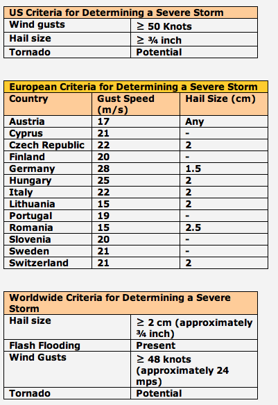
Criteria for Determining Severe Thunderstorms
- Criteria are based on surface conditions.
- The worldwide criteria are not standardized.
- The severity criteria are applicable to forecast and actually occurring storms.
- Forecast or actual occurrence of severe storms affects air traffic systems with delays and re-routing.
4
Tropical weather systems
Unstable Air
The air is generally unstable in the tropical region because the zone is characterized by:
- High water vapor
- Strong surface heating
Unstable air contributes to the formation of tropical weather systems by allowing warm air to rise.
The ITCZ
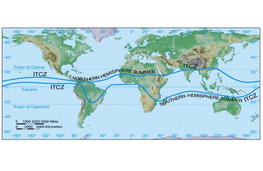
The Inter Tropical Convergence Zone, also known as ITCZ, is the zone where the North-east Trade winds converge toward or meet the South-east Trade winds.
The ITCZ is not uniform and tends to move:
- The earth's surface is not uniform since it is a mixture of land and water. Because the northern hemisphere has more land mass which heats more than water, the ITCZ tends to move into the northern hemisphere.
- The earth is tilted with respect to the sun, producing uneven heating between hemispheres.
- The ITCZ shifts to the hemisphere that is in its warm season to cause tropical weather systems.
Low-level winds
The upward air motion caused by the clockwise or counterclockwise turning of the low level N-E & S-E Trade winds allows transportation of water vapor aloft, which is necessary to produce clouds. This causes the formation of the tropical weather systems.
Upper-level winds
- The upper-level wind direction must diverge or spread apart so that air flows out of the top of the developing surface low pressure system.
- The surface pressure begins to drop.
- The wind speed increases.
- Rate of convergence increases.
- Upward motion increases.
Ocean water temperature
The ocean water temperature of 27° C or above is suitable for tropical weather formation.
Water vapor and its latent heat of condensation are required to support upward motion of air in the tropical weather formation process.
Characteristics of tropical weather systems
Influence of Upper-level Winds
- The steering winds are 500 mb (18000-foot).
- Tropical low-pressure systems will move in the direction of the 500 mb (18000-foot) steering winds at half their speed.
- Movement of the tropical low will be east to west in the tropical latitudes and change directions when closer to the middle latitudes.
- A tropical low-pressure system can turn to the northwest through northeast in the Northern Hemisphere.
- A tropical low-pressure system can turn to the southwest or southeast in the Southern Hemisphere.
- With the weakening of the steering winds, the movement of the tropical low-pressure systems can become erratic and unpredictable.
General Tracks
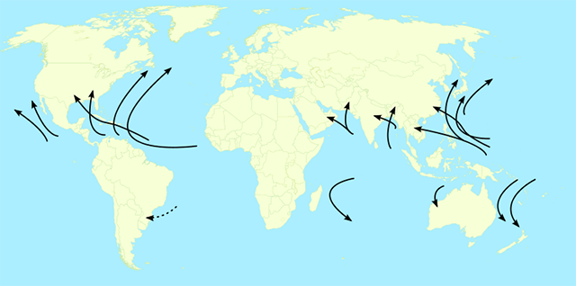
The formation area and tracks are not exact; they are general in nature.
Formation Months
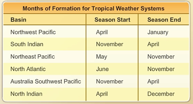
- The indicated months of formation are most likely months and therefore, not exact.
- Tropical weather systems tend to occur in the warm seasons of the hemispheres which are opposite to each other.
Characteristics of Tropical Weather Systems
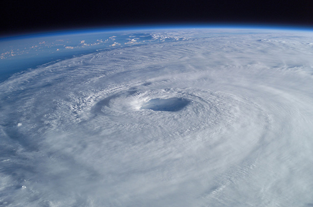
A tropical weather system is a low pressure system that develops as a result of convection in the tropical region which is between 23.5 degrees South latitude and 23.5 degrees North latitude during the warm weather season. The innermost clouds are usually TCUs and CBs. When an "eye" exists, the innermost clouds are called "wall clouds." The outer clouds are called "spiral bands."
The forms of tropical weather systems in increasing order of severity are:
- Tropical Depression
- Tropical Storm
- Hurricane, Typhoon, and Cyclone
Tropical depression
Tropical depression
- A low-pressure system in the first stage of development is called a ‘Depression’.
- For Atlantic and Pacific: Wind speed < 35 kts (64 kph)
- For Indian Ocean:
- Wind Speed: 7-27 knots (30-50 kph)
- Wind Speed: 28-33 knots (51-59 kph)—Deep Depression
Tropical storm
Tropical storm
- The second stage of a tropical weather system’s development is the tropical storm.
- For Atlantic and Pacific—Wind-speed:36-64 kts (67-118 kph)
- For Indian Ocean
- Cyclonic Storm—Wind-speed:34-47 kts (63-87 kph)
- Severe Cyclonic Storm—Wind-speed:48-63 kts (89-117 kph)
Hurricanes, typhoons and cyclones
Hurricane
The third stage of a tropical weather system:
- Hurricane in Atlantic
- Typhoon in Pacific
- Cyclone in Indian Ocean
Tropical weather systems have an average aerial coverage between 500 and 600 nm in diameter, made up of towering cumulus and cumulonimbus.
Wind speed criterion:
- Atlantic (Hurricane): Wind Speed > 64 knots (110 kph)
- Pacific (Typhoon): Wind Speed > 64 knots (110 kph)
- Indian Ocean (Very Severe Cyclone): 64 knots -119 knots (110 kph-220 kph)
- Indian Ocean (Super Cyclone): Wind Speed > 119 knots (220 kph)
The average aerial coverage for the tropical weather systems is in the range of 500 to 600 nm (900 to 1100 km) in diameter.
5
Hail
High-altitude Hail
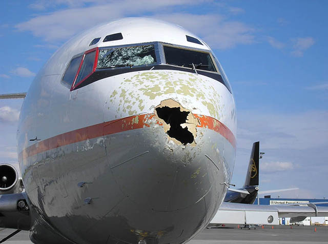
Characteristics
- Hail size ranges from 1/8th of an inch to 2.5 inches.
- Larger hail occurs in the form of hail shaft in the core of the cloud.
- We can encounter smaller hail, underneath the spreading cirrus or anvil blow-off, up to 30 miles from the edge of the storm.
- Smaller hail underneath the anvil can damage the following components of an aircraft:
- Leading edges
- Inlets and engines
- Windscreen
Avoidance Procedure
- Avoid penetrating a thunderstorm because of the existence of a hail shaft.
- Avoid flying under the overhang or the blow-off because you may encounter smaller hail.
- Ignoring the hail forecast in convective SIGMETS due to no-hail forecast or reported at the surface is not a good practice.
Low-altitude Hail
Characteristics
- Occurs at the core.
- Occurs in the overhang.
Avoidance Procedure
- Maintain a safe distance of 5 nm or more from the edge of the storm.
- Use METARs and PIREPs for any reported encounter with hail.
- Look at the track of the thunderstorm for hail.
- Do not position the aircraft under the base of an active storm.
- Use METAR or TAF information about CBs or the ceiling layer height if CBs are not reported or forecast.
- Do not hesitate to ask the air traffic system about reports of en-route hail.
6
Engine ice crystal ingestion
- Ice crystal ingestion can cause multiple engine as well as single engine flameout.
- Highest occurrence of flameouts by ice crystal ingestion is associated with convective weather.
- Ice crystals occur in abundance in the anvil of thunderstorms.
- High concentration of ice crystals can be found in the cloud debris on the lee side of clusters or lines of storms.
- General procedures:
- Avoid an encounter.
- Follow manufacturer's recommendation for maintaining ignition.
- If flameout occurs, follow manufacturer's recommendation for re-ignition.
7
Low Level Windshear (LLWS)
Characteristics
- Also known as LLWS, it arises out of the outflow from the base of a thunderstorm.
- The vertical component of the outflow pushes an aircraft down and the horizontal components alter its lift.
- Formula for Estimating LLWS:
- Range of Estimated Horizontal Wind Shear:
Lower End= Sustained Wind Speed + Gust Speed
Upper End= 2 X Gust Speed - Estimated Vertical Wind Shear= (Gust Speed X 100) fpm
Avoidance Procedure
- Refer to TAF or METAR for obtaining the gust speed.
- Refer to PIREPS for reported data for LLWS and use the formula to estimate the magnitude of shear.
- Immediately initiate escape maneuver for your aircraft if the on-board LLWS system alarms.
- Immediately initiate avoidance or escape maneuver if the airport LLWS system alarms.
- Avoid LLWS whether or not you have been able to estimate its magnitude.
- Stay 5 nm away from the edges of thunderstorms.
8
Sand and dust
Hazards of Sandstorms and Dust storms
- Low-level Windshear (LLWS)
- Windshear across the boundary
- Restricted visibility
- Often zero
- Even after winds drop
- Strong crosswind components
- Engine ingestion of sand or dust
Avoidance Procedures for Sandstorms and Dust storms
- Do not attempt to penetrate a moving wall of sand.
- Go to alternate airport.
- Refer to TAFs, METARs and other aviation weather advisories and forecast products.
Characteristics of dust devils and their avoidance procedure
- A dust-devil is a whirlwind or a vortex like a tornado.
- A dust devil's aerial coverage is much less than a tornado's.
- A dust devil's wind speed is less than a tornado's.
- Dust devils form in arid and semi-arid regions.
- Dust devils are highly localized.
- Width: 3-300 feet or 1-90 m
- Height: 100-3,000 feet or 30-900 m
- Wind speed: 25-80 knots or 12-40 mps
- Most dust devils are small and weak.
- Large dust devils can be destructive.
The avoidance procedure for dust devils is to avoid encountering them. Dust devils can easily be seen and therefore, are easy to avoid.
References
(Source material)
14 CFR 91, Title 14: Aeronautics and Space, General Operating and Flight Rules, Federal Aviation Administration, Department of Transportation
14 CFR 135, Title 14: Aeronautics and Space, Operating Requirements: Commuter and On Demand Operations and Rules Governing Persons on Board Such Aircraft, Federal Aviation Administration, Department of Transportation
Aeronautical Information Manual