If you aren't used to flying to an airport in the middle of a Class B, say KJFK, it can be quite the ordeal. If you are flying into an airport where the English in use is nothing like you've ever heard before, well that can be a shock too.
— James Albright

Updated:
2022-08-21
I was fortunate to go through this process as a second lieutenant in the Air Force, where a certain amount of stupidity was expected from the rank. Yes, I said stupidity. It isn't that you are stupid, but you will feel stupid. So let's figure out a way to avoid all that.
First I have an example from my notes way back when. Then an update on how to make use of all the technology available to us.

1
An example of the process
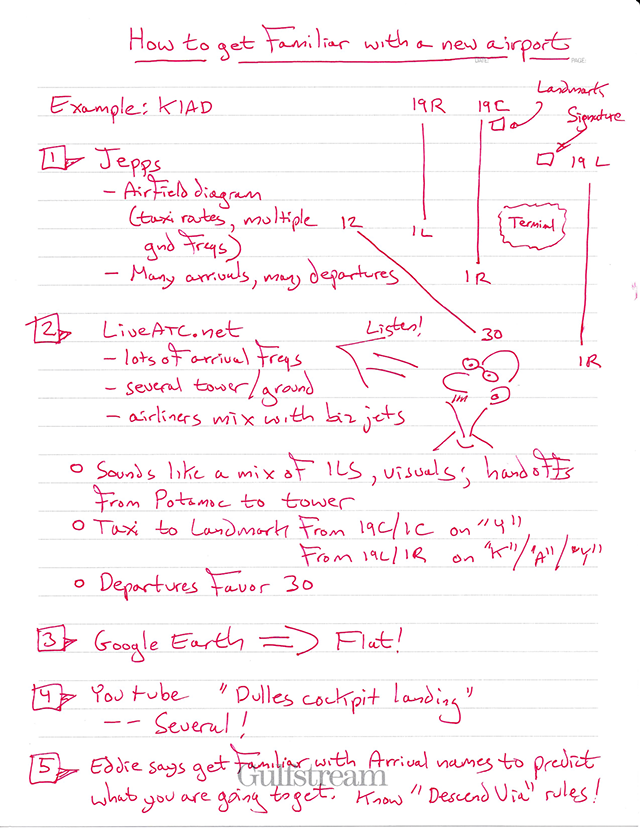
An example of the process
The following list certainly will not fully prepare you, but it will get you started. Speaking of getting started, I recommend you look at this too: Airport Selection. It will cover many of the basics for those more exotic trips.
But what about an airport in the United States that has a fearsome reputation and you've never been? Here is what I recommend:
- Jepps — Pull up the Jepps and get familiar with the arrivals, approaches, runways, ramps, radio frequencies, and departures. It is especially helpful to predict the likely arrivals and departures based on your route of flight, to get to know the names so you recognize them more easily when spoken on the radio. Get an idea of which runways have the best approaches and how you can best back up a visual approach if offered. Figure out the taxi routes. Don't forget to print out any Class B areas and bring that with you.
- Preview the Radios — The airport may have live streaming audio of approach control, tower, ground control, clearance delivery, departure control, and even ATIS. Give http://www.liveatc.net a try. If that doesn't work, just type it into your Internet search engine, you might get lucky. If you do find it, listen to the applicable frequencies for an hour or so. Get to know the tempo and any unique phraseologies. You can better learn how things are done if you listen for a while, especially at the same time of day when you expect to fly there.
- Google Earth — If you don't have Google Earth, get it. It's free. With it you can get a look at the airport and surrounding terrain.
- YouTube — There are lots of pilots out there who take cockpit videos, wanting to share the experience. You should be able to type the name of the airport followed by the words "cockpit landing" and get a front seat view of how it is done.
- Peers — The best resource may be in your flight department or one of your friends from a previous life. Pick up the phone and ask "is there anything there I should know about?" An even better question is this: "Have you ever had a bad experience at ____?"
- ASRS — Another fine resource is the NASA Aviation Safety Reporting System (ASRS) data base, available here: http://asrs.arc.nasa.gov/search/database.htm. You can search for reports by aircraft type, location, etc. It is a good way to find things that have tripped up others.
I have an example of my notes above of Washington Dulles. I really recommend the Internet sources I've given here. You have a huge advantage these days in that you can visit a lot of these airports from the comfort of your home or hotel room. In my early days we called this "chair flying," where you flew the entire flight in your mind to foresee the problems. "Be the ball." Now you can do it and actually learn from the experiences of others. Good luck.
2
Flying to a new destination

Destinations sign,
Union Glacier Airport, Antarctica
(Shutterstock)
As professional pilots, we become so well practiced at flying to airports we’ve never seen before it becomes almost second nature. Is the runway long enough and will it support the weight of our aircraft? What instrument approaches are available? Are there any obstacle considerations? What local support is available? The questions go on, but we know most of the answers are available from any computer with an Internet connection or, sometimes, we must pick up a phone. But is it that easy for all airports? There are some destinations that require more than our normal checklists because we don’t even know the right questions to ask.
What does AcuKwik have about the destination?
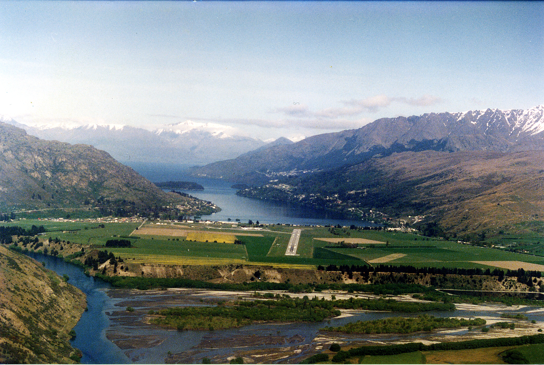
Final approach to Queenstown Airport, New Zealand (Phillip Capper)
Like many pilots, my starting point is acukwik.com, where I get the usual airport and FBO information. But I go beyond that by digging further into the various provided links. Going to Queenstown Airport (NZQN), New Zealand, for example, you might have heard the approaches require a dive over mountains from all quadrants. Acukwik provided links to the airport’s FBOs and one of those led to this gem: https://aircenterone.co.nz/services/flight-videos/, with videos of the approaches. For obstacle analysis, a photo might be worth a thousand words, but a video would be worth a thousand photos. The AirCenter One website also promised a briefing packet with an email request; the provided information was invaluable.
Is destination-specific training required?
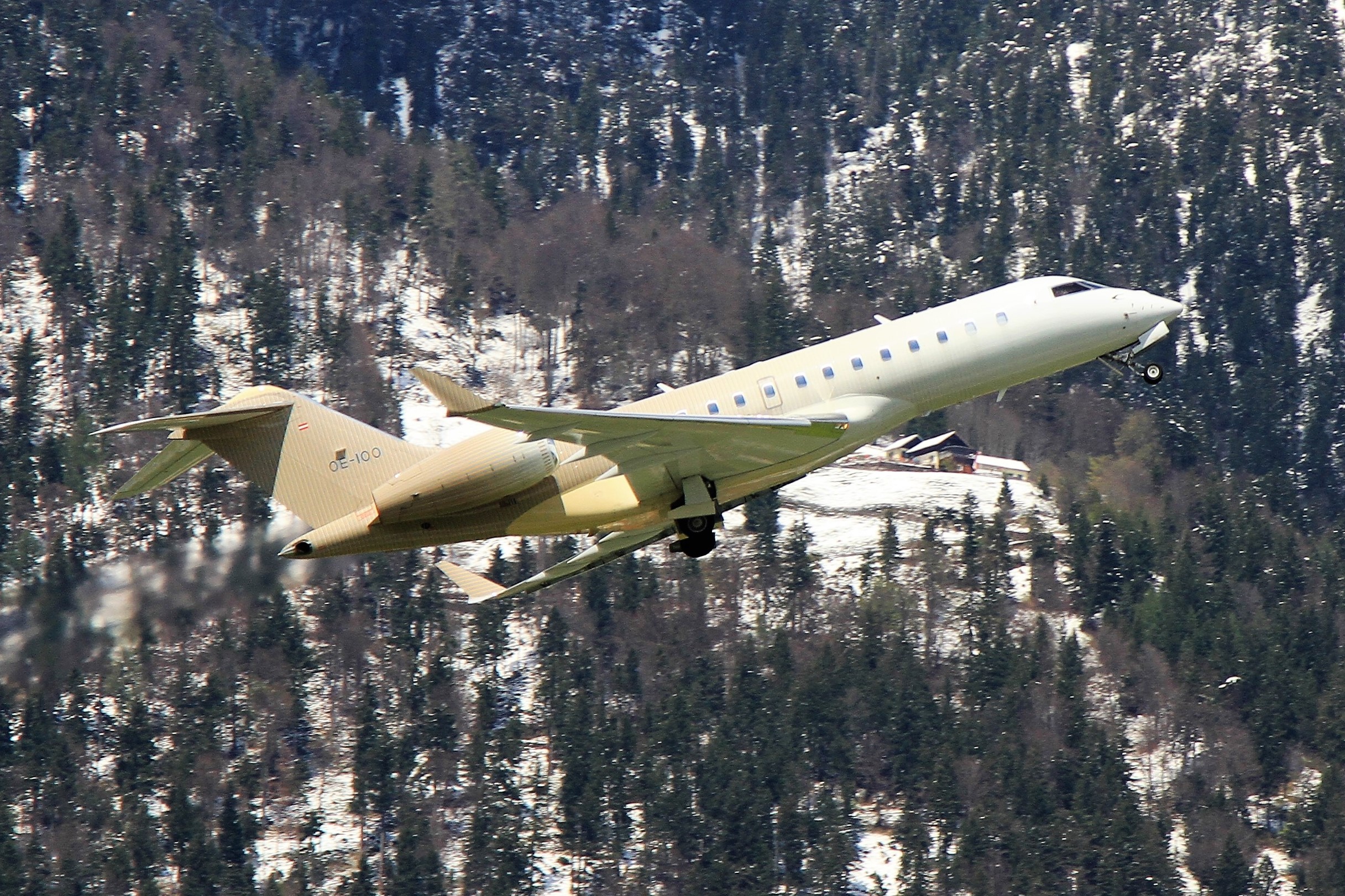
A Global 5000 departs Innsbruck (Photo: Rob Hodgkins)
We know some destinations are going to be a special challenge just because their names evoke visceral images of tall mountains and deep valleys. When we were first scheduled into Innsbruck Airport (LOWI), Austria, we suspected we wouldn’t be allowed to go without special training. A quick look at acukwik.com, confirmed our suspicions. We sent our two scheduled pilots and a backup pilot to the Innsbruck training course offered by FlightSafety International. The ground school and simulator sessions were invaluable. Approach and missed approach procedures are not intuitive and the best way to learn about this airport is to fly everything in day, visual meteorological conditions. The synthetic view of the towering mountains was excellent preparation for the real thing.
Does the destination have an accident history?
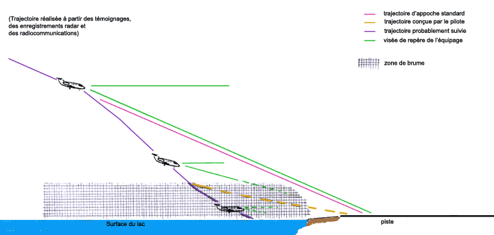
I think many airports have insidious challenges that have claimed unsuspecting pilots before and lay in wait to do it again. The Flight Safety Foundation has an excellent database for researching aviation accidents at aviation-safety.net. Selecting Database, ASN Accident Database, and Airport will make short work of your search. Looking for Chambéry Airport (LFLB), France, for example, returns four accidents. The 1998 crash of a Gulfstream GIII reveals that mist over the Lake of le Bourget can result in the loss of visual references, so it is critical to remain on the ILS even if you think you have the runway in sight well before minimums. Further research revealed the ILS glide path is 4.46°, just shy of the 4.5° limit for many aircraft. While a practice run in a simulator isn’t required by the airport, it proved a useful precaution. The approach requires you to configure early, stay on speed and glide path, and resist the temptation to fly visually too early.
More about this: Case Study Gulfstream GIII VP-BLN.
What are the threats?
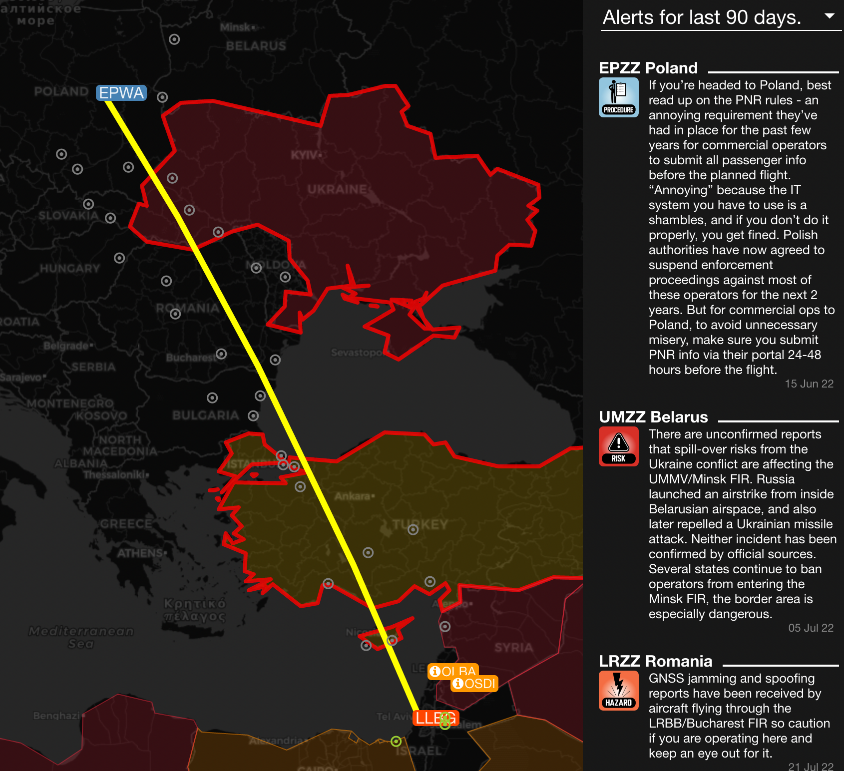
ops.group alerts from Warsaw to Tel Aviv for a particular day in August
Some airports don’t have mountains to worry about, but threats of other kinds abound. My favorite source of timely and critical flight information comes from ops.group. A membership is required but there is no better source of vital intelligence. I recently planned a trip from Warsaw Chopin Airport (EPWA), Poland to Ben Gurion Airport (LLBG), Israel and discovered a few things I didn’t know about to add to the obvious war threats I did know of. Besides the war in Ukraine, I learned that many operators are also avoiding the airspace over Belarus, there are reports of GPS jamming over Romania, there are bomb threats at several Moldova airports, Syria is an active conflict zone, there are missile threats in Damascus, and there have been rockets fired into Israel earlier in the month. Many of these threats are absent from Notice to Airmen (NOTAMs) or are published well after the threat has begun.
Besides the war threats, ops.group also tells us about mandatory permits needed in Poland and Israel, as well as overflight permits for many of the countries between our departure and landing and for landing at many of our possible alternates. If you fly internationally, there is no substitute for ops.group. They count as subscribers, hundreds of airlines and thousands of operators, providing the best intel of all. For example, I have been a frequent visitor to Paris Le Bourget (LFPB), France. I once found out the airport was closed every night for a week, something the NOTAMs didn’t know until a few days after the closures started. Subscriptions come to $35/month for an individual or $10/person/month for a team plan. It is money well spent.
Can a social media contact help?
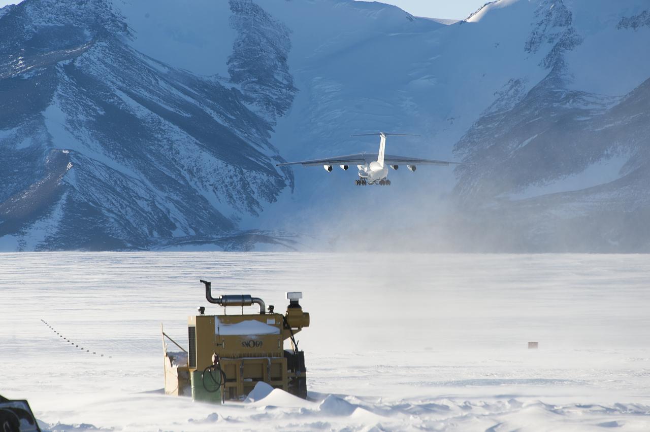
An Illyushin IL-76 takes off from Union Glacier Blue-Ice Runway in Antarctica (Chrisopher Michel)
If a destination has proven to be a challenge for other pilots, chances are one of those who beat the challenge has posted a report on social media. Simply typing in the airport name and “pilot report” can yield a treasure trove of information and new contacts with recent information. For our Tel Aviv trip, for example, I learned about the need to call ahead to Nicosia Control 10 minutes before entering their airspace. There are customs and immigration rules at the airport unlike those at any other countries, but these procedures change. Having a social media contact who has been to your destination recently can save you time and money, as well as a little embarrassment from being caught unaware of the latest restriction.
The National Business Aviation Association (nbaa.org) and Universal Weather & Aviation, Inc. (universalweather.com) offer timely information submitted by recent visitors. Blogs can be illuminating as well as entertaining. Facebook offers many groups with many professional aviators willing to answer your latest questions. For sheer volume of participants, it is hard to beat the Facebook “Professional Jet Pilots” group with over 15,000 members. If you have a question about a particular destination, at least one of those members should be able to help you out. Once you are in the group, you can search for discussions by the airport name and then you can send a private message to the writer to get even more help.
It is hard to imagine a more out of the way destination than Union Glacier (SCGC), Antarctica, just seven degrees south of the geographic south pole. Coordinates: 79°46′40″S 83°19′15″W. I challenge you to find any information about this airport at your normal aviation websites. Through the Facebook Professional Jet Pilots group: the flight plan has to be filed locally, there are no ARINC latitude/longitude “short codes” so waypoints, HF hardly works at all so a Satphone or CPDLC are necessary, the airport doesn’t exist in most databases so you might have to manually program pressurization systems and your Enhanced Ground Proximity Warning System, and you are unlikely to find instrument approach plates.
Can you do a “dry run” from your computer?

The Juneau Airport (PAJN), Alaska at the end of the Gastineau Channel
Some destinations must be seen to be believed. A friend was planning a trip from Ted Stevens Anchorage International Airport (PANC), Alaska to Juneau International Airport (PAJN), Alaska and wanted to see what an approach to Runway 8 would look like. He used the “3D view” available in any of ForeFlight’s Performance Plans from the Airports View menu. (https://foreflight.com/) This opens an interactive window which allows you to pan and zoom the airport area to familiarize yourself with the surrounding terrain and obstacles. Additionally, an Instrument Approach “3D Procedure Preview” option is available when the instrument approach is selected from the Maps FPL window. A third feature, a 3D Preview for the entire route of flight, is selectable from the Maps FPL window. This gives you a chance to view the flight beforehand, including the finer details of the instrument procedures.
(A ForeFlight 3-Dimensional view of a flight from to Juneau, courtesy Steven Foltz)
The approach into Juneau’s Runway 8 appears straight forward but that isn’t the case with Runway 26, which requires aircraft to fly the narrow Gastineau Channel with mountains towering on either side. The only instrument approach from the south is the Required Navigation Performance (RNP) Procedures with Authorization Required (AR). When I became RNP AR trained to qualify for the C384 authorization, the simulator didn’t have the Juneau approach available. But I still wanted to see the approach in all its 3-Dimensional glory to fully appreciate the challenge and thought Google Earth’s animation might help.
The easiest way to preview a flight is to take the FlightAware history of someone’s previous flight. You simply search the route by entering the origin and destination and select a flight that has already occurred. I was interested in the RNP AR approach into Juneau, so I looked for a flight from Seattle to Juneau and was presented with several Alaska Airlines flights. I selected one and then selected “View track log” and the Google Earth button which sent a “kml” (Keyhole Markup Language) file to my computer. I imported that into Google Earth Studio and got a 3-Dimensional view of that airliner’s flight. After viewing a few tutorials, I learned how to turn that into a video suitable for training my fellow pilots on what we had in store for us. Learning to do this may take several hours but once you’ve got the process down, it only takes a few minutes and will be an invaluable tool in your arsenal. Google Earth Studio is available free of charge at https://earth.google.com/studio and the site includes many tutorials.
(A Google Earth 3-Dimensional view of a flight through the Gastineau Channel to Juneau)
You can’t go unless you’ve been?
Back in the days when the United States Air Force had bases spread all over the world for its fighters and bombers, we in the Military Airlift Command were also tasked with flying to far flung airports that few of us had ever seen or heard of. The conventional scheduling process was “you can’t go unless you’ve been.” In other words, somebody on the crew must have experienced the new destination’s challenges to train the next crop of crewmembers. Of course, we had to make exceptions; the mission did not stop for lack of prior experience. So too it is with us in business aviation. We are often the first that we know to go. The advantage we have today, however, is that we have vast resources to hear from those who have been there before us. Our challenge becomes to know where to look and then, simply, ask.